
Size of this PNG preview of this SVG file:
800 × 495 pixels. Other resolutions:
320 × 198 pixels |
640 × 396 pixels |
1,024 × 633 pixels |
1,280 × 791 pixels |
2,560 × 1,583 pixels |
959 × 593 pixels.
Original file (SVG file, nominally 959 × 593 pixels, file size: 54 KB)
| This is a file from the
Wikimedia Commons. Information from its
description page there is shown below. Commons is a freely licensed media file repository. You can help. |
Summary
| Description |
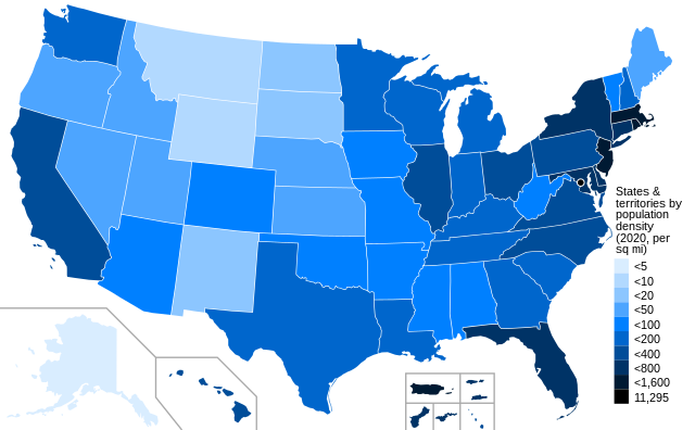
English: U.S. states and territories shaded by population density as of the 2020 census. Darker colors indicate greater density. |
| Date | |
| Source | File:Blank USA, w territories.svg |
| Author | Crossover1370 |
Licensing
I, the copyright holder of this work, hereby publish it under the following license:
This file is licensed under the
Creative Commons
Attribution-Share Alike 4.0 International license.
- You are free:
- to share – to copy, distribute and transmit the work
- to remix – to adapt the work
- Under the following conditions:
- attribution – You must give appropriate credit, provide a link to the license, and indicate if changes were made. You may do so in any reasonable manner, but not in any way that suggests the licensor endorses you or your use.
- share alike – If you remix, transform, or build upon the material, you must distribute your contributions under the same or compatible license as the original.
File history
Click on a date/time to view the file as it appeared at that time.
| Date/Time | Thumbnail | Dimensions | User | Comment | |
|---|---|---|---|---|---|
| current | 21:38, 20 January 2022 |
| 959 × 593 (54 KB) | Crossover1370 | correct Vermont's population density |
| 00:50, 19 January 2022 |
 | 959 × 593 (46 KB) | Crossover1370 | change to 12-point font - looks less cluttered and matches my other maps | |
| 00:38, 19 January 2022 |
 | 959 × 593 (46 KB) | Crossover1370 | Uploaded own work with UploadWizard |
File usage
The following pages on the English Wikipedia use this file (pages on other projects are not listed):
Global file usage
The following other wikis use this file:
- Usage on hu.wikipedia.org
- Usage on zh.wikipedia.org