No higher resolution available.
Truckeerivermap.png (500 × 500 pixels, file size: 337 KB, MIME type: image/png)
| This is a file from the
Wikimedia Commons. Information from its
description page there is shown below. Commons is a freely licensed media file repository. You can help. |
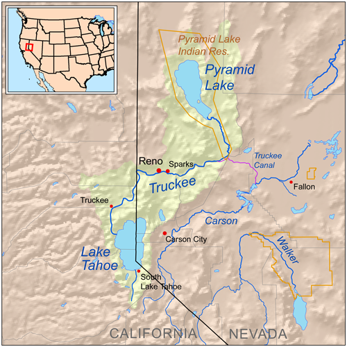
| Description | Map showing the Truckee River drainage basin — in California and Nevada. |
| Date | |
| Source | Self-made, based on USGS data. |
| Author | Kmusser |
| Permission ( Reusing this file) |
I, the copyright holder of this work, hereby publish it under the following license: This file is licensed under the
Creative Commons
Attribution-Share Alike 3.0 Unported license.
|
File history
Click on a date/time to view the file as it appeared at that time.
| Date/Time | Thumbnail | Dimensions | User | Comment | |
|---|---|---|---|---|---|
| current | 14:30, 31 July 2008 |
| 500 × 500 (337 KB) | Kmusser | == Summary == {{Information |Description=Map showing the Truckee River drainage basin. |Source=Self-made, based on USGS data. |Author= Kmusser |Date=July 31, 2008 |Permission= |other_versions= }} [[Categ |
File usage
The following pages on the English Wikipedia use this file (pages on other projects are not listed):
Global file usage
The following other wikis use this file:
- Usage on de.wikipedia.org
- Usage on es.wikipedia.org
- Usage on it.wikipedia.org
- Usage on ja.wikipedia.org
- Usage on ml.wikipedia.org
- Usage on nl.wikipedia.org
- Usage on pl.wikipedia.org
- Usage on ru.wikipedia.org
- Usage on www.wikidata.org