Original file (1,117 × 622 pixels, file size: 25 KB, MIME type: image/png)
| This is a file from the
Wikimedia Commons. Information from its
description page there is shown below. Commons is a freely licensed media file repository. You can help. |
Summary
| Description |
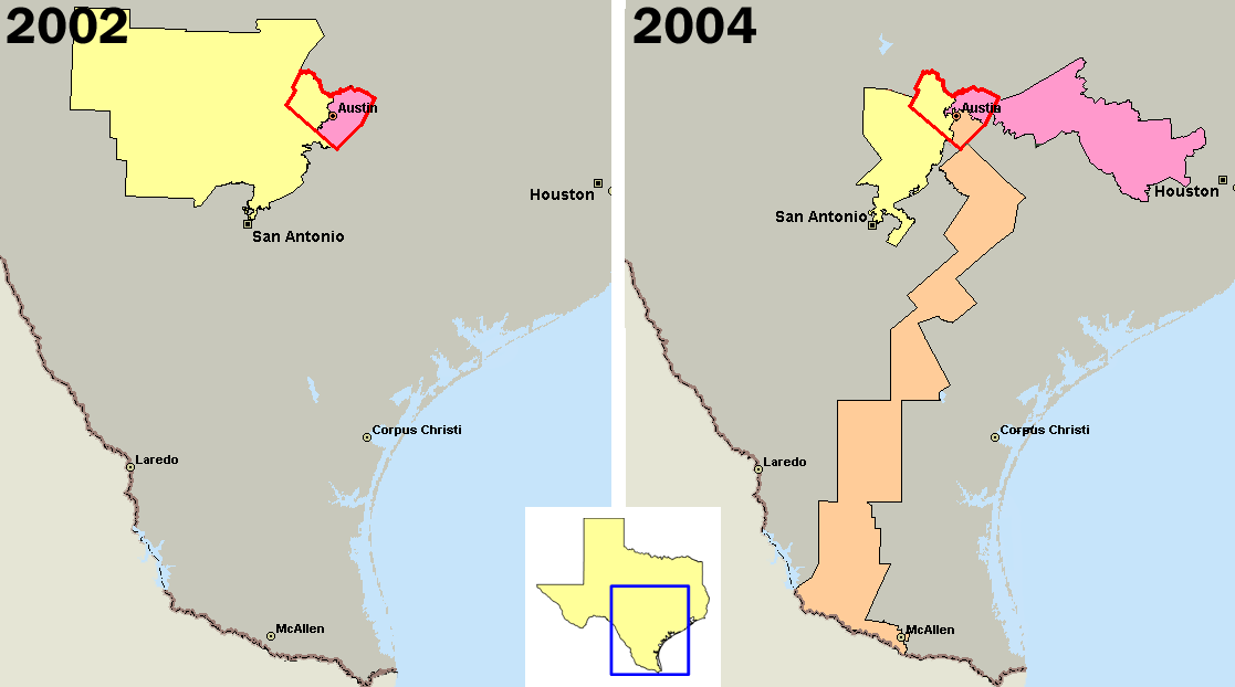
U.S. congressional districts covering en:Travis County, Texas (outlined in red) in 2002, left, and 2004. In 2003, Republicans in the Texas legislature redistricted the state, diluting the voting power of the heavily Democratic county by parceling its residents out to more Republican districts. Created by me using Microsoft MapPoint 2004 and data from http://nationalatlas.gov The district in orange is the infamous "Fajita strip" district 25 (intended as a Democratic district), while the other two districts (10 and 21) are intended to elect Republicans. District 25 has now been redrawn as a result of the 2006 U.S. Supreme Court decision, and is no longer a "Fajita strip".
|
||
| Date | 29 September 2005 (original upload date) | ||
| Source | Transferred from en.wikipedia to Commons. | ||
| Author | PHenry at English Wikipedia |
Licensing
| This work has been released into the
public domain by its author,
PHenry at
English Wikipedia. This applies worldwide. In some countries this may not be legally possible; if so: PHenry grants anyone the right to use this work for any purpose, without any conditions, unless such conditions are required by law. |
Original upload log
- 2005-09-29 03:58 PHenry 1117×622×8 (25178 bytes) Created by me using Microsoft MapPoint 2004 and data from http://nationalatlas.gov
File history
Click on a date/time to view the file as it appeared at that time.
| Date/Time | Thumbnail | Dimensions | User | Comment | |
|---|---|---|---|---|---|
| current | 12:04, 25 March 2007 |
| 1,117 × 622 (25 KB) | Liftarn | {{Information |Description=U.S. congressional districts covering en:Travis County, Texas (outlined in red) in 2002, left, and 2004. In 2003, Republicans in the Texas legislature redistricted the state, diluting the voting power of the heavily Democra |
File usage
Global file usage
The following other wikis use this file:
- Usage on es.wikipedia.org
- Usage on it.wikipedia.org
- Usage on nl.wikipedia.org
- Usage on pt.wikipedia.org
- Usage on www.wikidata.org