
Size of this preview:
750 × 600 pixels. Other resolutions:
300 × 240 pixels |
600 × 480 pixels |
960 × 768 pixels |
1,280 × 1,024 pixels |
2,560 × 2,048 pixels |
5,000 × 4,000 pixels.
Original file (5,000 × 4,000 pixels, file size: 3.74 MB, MIME type: image/jpeg)
| This is a file from the
Wikimedia Commons. Information from its
description page there is shown below. Commons is a freely licensed media file repository. You can help. |
Summary
| Description |
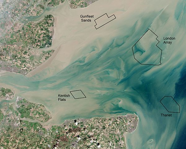
English: Thames Estuary and Wind Farms from Space NASA. Windfarms visible in the image are:
London Array,
Thanet Wind Farm,
Kentish Flats Wind Farm and
Gunfleet Sands Wind Farm. Kentish Flats is pictured before its 2015 extension was constructed. |
| Date | |
| Source | Annotated version of File:Thames Estuary and Wind Farms from Space NASA.jpg showing offshore wind farms |
| Author | Operational Land Imager, with annotations by Delusion23 |
| Other versions |
 (no annotations) |
| Camera location |
| View this and other nearby images on: OpenStreetMap |
|
|---|
Licensing
| This file is in the public domain in the United States because it was solely created by NASA. NASA copyright policy states that "NASA material is not protected by copyright unless noted". (See Template:PD-USGov, NASA copyright policy page or JPL Image Use Policy.) | ||
 |
Warnings:
|
| Annotations | This image is annotated: View the annotations at Commons |
File history
Click on a date/time to view the file as it appeared at that time.
| Date/Time | Thumbnail | Dimensions | User | Comment | |
|---|---|---|---|---|---|
| current | 21:23, 22 June 2015 |
| 5,000 × 4,000 (3.74 MB) | Delusion23 | User created page with UploadWizard |
File usage
The following pages on the English Wikipedia use this file (pages on other projects are not listed):
Global file usage
The following other wikis use this file:
- Usage on fr.wikipedia.org
- Usage on ig.wikipedia.org
- Usage on it.wikipedia.org
- Usage on ja.wikipedia.org
- Usage on nl.wikipedia.org
- Usage on ru.wikipedia.org
- Usage on sv.wikipedia.org
- Usage on vi.wikipedia.org
- Usage on zh.wikipedia.org