
Size of this preview:
800 × 569 pixels. Other resolutions:
320 × 228 pixels |
640 × 455 pixels |
1,024 × 728 pixels |
1,118 × 795 pixels.
Original file (1,118 × 795 pixels, file size: 1.45 MB, MIME type: image/png)
| This is a file from the
Wikimedia Commons. Information from its
description page there is shown below. Commons is a freely licensed media file repository. You can help. |
Summary
| Description |
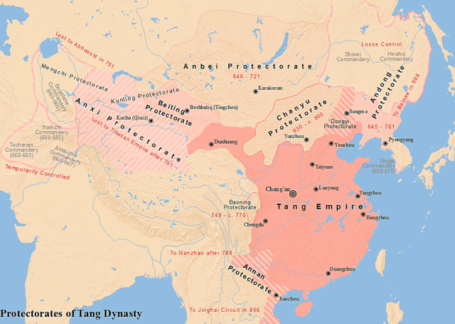
English: Map of the six major protectorates during Tang dynasty. A reference: (in English) (26 July 2021)
Warfare in Chinese History, BRILL, p. 119, map 2 "Inner Asia circa 660"
ISBN:
978-90-04-48294-4.
中文(中国大陆):唐朝的六大都护府示意地图 |
| Date | |
| Source | Own work |
| Author | SY |
| Other versions |
  |
Licensing
I, the copyright holder of this work, hereby publish it under the following license:
This file is licensed under the
Creative Commons
Attribution-Share Alike 4.0 International license.
- You are free:
- to share – to copy, distribute and transmit the work
- to remix – to adapt the work
- Under the following conditions:
- attribution – You must give appropriate credit, provide a link to the license, and indicate if changes were made. You may do so in any reasonable manner, but not in any way that suggests the licensor endorses you or your use.
- share alike – If you remix, transform, or build upon the material, you must distribute your contributions under the same or compatible license as the original.
File history
Click on a date/time to view the file as it appeared at that time.
| Date/Time | Thumbnail | Dimensions | User | Comment | |
|---|---|---|---|---|---|
| current | 22:10, 29 January 2018 |
| 1,118 × 795 (1.45 MB) | Seasonsinthesun | More detailed version |
| 23:29, 14 July 2017 |
 | 844 × 607 (551 KB) | Seasonsinthesun | User created page with UploadWizard |
File usage
The following pages on the English Wikipedia use this file (pages on other projects are not listed):
Global file usage
The following other wikis use this file:
- Usage on ce.wikipedia.org
- Usage on el.wikipedia.org
- Usage on es.wikipedia.org
- Usage on fr.wikipedia.org
- Usage on id.wikipedia.org
- Usage on it.wikipedia.org
- Usage on km.wikipedia.org
- Usage on ko.wikipedia.org
- Usage on ms.wikipedia.org
- Usage on mt.wikipedia.org
- Usage on pnb.wikipedia.org
- Usage on pt.wikipedia.org
- Usage on ru.wikipedia.org
- Usage on tr.wikipedia.org
- Usage on uk.wikipedia.org
- Usage on uz.wikipedia.org
- Usage on vi.wikipedia.org
- Usage on zh.wikipedia.org