No higher resolution available.
Site_of_the_Battle_of_Beecher_Island_as_it_appeared_in_1917.jpg (640 × 342 pixels, file size: 40 KB, MIME type: image/jpeg)
| This is a file from the
Wikimedia Commons. Information from its
description page there is shown below. Commons is a freely licensed media file repository. You can help. |
|
This is an image of a place or building that is listed on the
National Register of Historic Places in the
United States of America. Its reference number is
76000569. |
Summary
| Description |
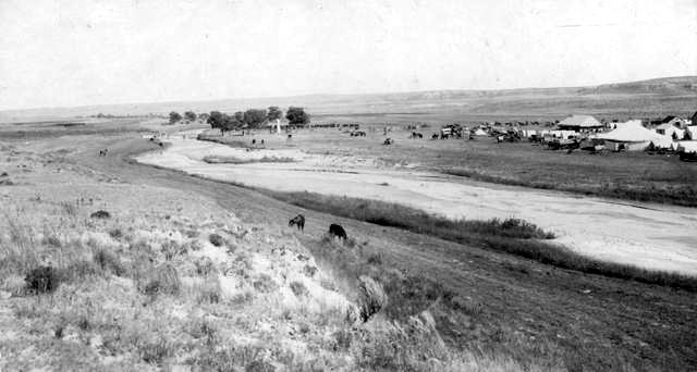
English: The site of the 1868
Battle of Beecher Island — as it appeared in 1917.
|
| Source | Earl Alonzo Brininstool |
| Author | Earl Alonzo Brininstool |
| Object location |
| View this and other nearby images on: OpenStreetMap |
|
|---|
Licensing
This media file is in the
public domain in the
United States. This applies to U.S. works where the copyright has expired, often because its first
publication occurred prior to January 1, 1929, and if not then due to lack of notice or renewal. See
this page for further explanation.
|
 | |
 |
This image might not be in the public domain outside of the United States; this especially applies in the countries and areas that do not apply the
rule of the shorter term for US works, such as Canada, Mainland China (not Hong Kong or Macao), Germany, Mexico, and Switzerland. The creator and year of publication are essential information and must be provided. See
Wikipedia:Public domain and
Wikipedia:Copyrights for more details.
|
Original upload log
The original description page was
here. All following user names refer to en.wikipedia.
- 2006-06-30 21:18 Lordkinbote 640×342× (40670 bytes) The site of the Battle of Beecher Island as it appeared in 1917. The south channel of the Arickaree has been closed, owing to the sifting sands of the stream. Shown are tents, buildings, horses, and cattle at an annual scout reunion to commemorate the
File history
Click on a date/time to view the file as it appeared at that time.
| Date/Time | Thumbnail | Dimensions | User | Comment | |
|---|---|---|---|---|---|
| current | 03:01, 5 October 2011 |
| 640 × 342 (40 KB) | File Upload Bot (Magnus Manske) | {{BotMoveToCommons|en.wikipedia|year={{subst:CURRENTYEAR}}|month={{subst:CURRENTMONTHNAME}}|day={{subst:CURRENTDAY}}}} {{Information |Description={{en|The site of the Battle of Beecher Island as it appeared in 1917. The south channel of the Arickaree has |
File usage
The following pages on the English Wikipedia use this file (pages on other projects are not listed):
Global file usage
The following other wikis use this file:
- Usage on de.wikipedia.org
- Usage on es.wikipedia.org
- Usage on ur.wikipedia.org
- Usage on www.wikidata.org