
Original file (1,470 × 1,701 pixels, file size: 327 KB, MIME type: image/jpeg)
| This is a file from the
Wikimedia Commons. Information from its
description page there is shown below. Commons is a freely licensed media file repository. You can help. |
Summary
| Description |
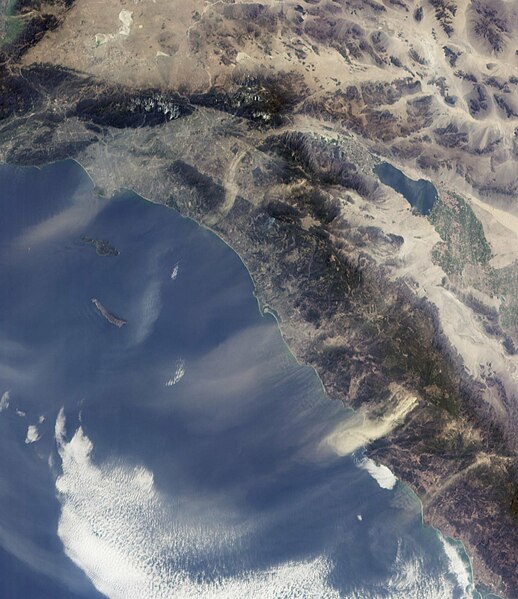
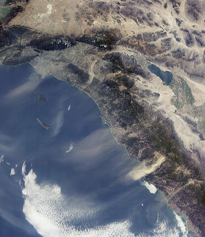
The Santa Ana winds in Southern California sweep down across the deserts and across the Los Angeles Basin pushing dust and smoke from wildfires far out into the Pacific Ocean. This view from the Multi-angle Imaging SpectroRadiometer shows the pattern of airborne dust stirred up by Santa Ana winds on February 9, 2002. The image is from MISR's 70-degree forward-viewing camera, and airborne particulates are especially visible due to the camera's oblique viewing angle. Southeast of the Los Angeles Basin, a swirl of dust, probably blown through the Banning Pass, curves toward the ocean near Dana Point. The largest dust cloud occurs near Ensenada, in Baja California, Mexico. Also visible in this image is a blue-gray smoke plume from a small fire located near the southern flank of Palomar Mountain in Southern California. This image was acquired during Terra orbit 11423, and represents an area of about 410 kilometers x 511 kilometers. |
| Date | |
| Source | http://photojournal.jpl.nasa.gov/catalog/PIA03445 |
| Author | NASA/JPL-Caltech |
This image or video was catalogued by Jet Propulsion Laboratory of the United States
National Aeronautics and Space Administration (NASA) under Photo ID:
PIA03445. This tag does not indicate the copyright status of the attached work. A normal copyright tag is still required. See Commons:Licensing. Other languages:
|
Licensing
| This file is in the public domain in the United States because it was solely created by NASA. NASA copyright policy states that "NASA material is not protected by copyright unless noted". (See Template:PD-USGov, NASA copyright policy page or JPL Image Use Policy.) | ||
 |
Warnings:
|
| Annotations | This image is annotated: View the annotations at Commons |
File history
Click on a date/time to view the file as it appeared at that time.
| Date/Time | Thumbnail | Dimensions | User | Comment | |
|---|---|---|---|---|---|
| current | 17:52, 10 December 2005 |
| 1,470 × 1,701 (327 KB) | Saperaud~commonswiki | cropped |
| 06:10, 3 September 2005 |
 | 1,684 × 1,860 (321 KB) | Epolk | The Santa Ana winds in Southern California sweep down across the deserts and across the Los Angeles Basin pushing dust far out into the Pacific Ocean. Courtesy NASA/JPL-Caltech |
File usage
Global file usage
The following other wikis use this file:
- Usage on ar.wikipedia.org
- Usage on bg.wikipedia.org
- Usage on bh.wikipedia.org
- Usage on ca.wikipedia.org
- Usage on cs.wikinews.org
- Usage on de.wikipedia.org
- Usage on en.wikinews.org
- Usage on en.wikiversity.org
- Usage on en.wiktionary.org
- Usage on es.wikipedia.org
- Usage on fr.wikipedia.org
- Utilisateur:Mandariine
- Vent de Santa Ana
- Utilisateur:GhosterBot/BacASable/Le saviez-vous ?/Archives
- Wikipédia:Le saviez-vous ?/Archives/2023
- Discussion:Vent catabatique
- Wikipédia:Statistiques des anecdotes de la page d'accueil/Visibilité des anecdotes (2023)
- Discussion:Vent catabatique/LSV 21993
- Wikipédia:Statistiques des anecdotes de la page d'accueil/Visibilité des anecdotes (2023)/2023 02
- Projet:Aide et accueil/Twitter/Tweets/archives/février 2023
- Wikipédia:Wikimag/2023/9
- Usage on fr.wiktionary.org
- Usage on he.wikipedia.org
- Usage on hi.wikipedia.org
- Usage on it.wikipedia.org
- Usage on ja.wikipedia.org
- Usage on mk.wikipedia.org
- Usage on ms.wikipedia.org
- Usage on nn.wikipedia.org
- Usage on pl.wikipedia.org
- Usage on ru.wikipedia.org
- Usage on sq.wikipedia.org
- Usage on www.wikidata.org
- Usage on zh.wikipedia.org