
Size of this PNG preview of this SVG file:
270 × 330 pixels. Other resolutions:
196 × 240 pixels |
393 × 480 pixels |
628 × 768 pixels |
838 × 1,024 pixels |
1,676 × 2,048 pixels.
Original file (SVG file, nominally 270 × 330 pixels, file size: 321 KB)
| This is a file from the
Wikimedia Commons. Information from its
description page there is shown below. Commons is a freely licensed media file repository. You can help. |
Summary
| Description |
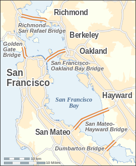
English: Map of the
bridges of San Francisco Bay — in the
San Francisco Bay Area, California.
|
| Date | |
| Source |
Own work This W3C-unspecified
vector image was created with
Inkscape . |
| Author | Alexrk |
| Other versions | Derivative works of this file: San Francisco Bay Bridges map ar.pngDerivative works of this file: San Francisco Bay Bridges map ar.svg |

|
This map has been made or improved in the German
Kartenwerkstatt (Map Lab). You can
propose maps to improve as well.
|

|
This SVG file contains embedded text that can be translated into your language, using any capable SVG editor, text editor or the SVG Translate tool. For more information see: About translating SVG files. |
Licensing
I, the copyright holder of this work, hereby publish it under the following license:
This file is licensed under the
Creative Commons
Attribution-Share Alike 3.0 Unported license.
- You are free:
- to share – to copy, distribute and transmit the work
- to remix – to adapt the work
- Under the following conditions:
- attribution – You must give appropriate credit, provide a link to the license, and indicate if changes were made. You may do so in any reasonable manner, but not in any way that suggests the licensor endorses you or your use.
- share alike – If you remix, transform, or build upon the material, you must distribute your contributions under the same or compatible license as the original.
File history
Click on a date/time to view the file as it appeared at that time.
| Date/Time | Thumbnail | Dimensions | User | Comment | |
|---|---|---|---|---|---|
| current | 14:14, 24 July 2008 |
| 270 × 330 (321 KB) | Alexrk | |
| 15:14, 19 July 2008 |
 | 270 × 330 (321 KB) | Alexrk | 2 Scales: km & mi | |
| 14:01, 19 July 2008 |
 | 270 × 330 (318 KB) | Alexrk | Scale, Size | |
| 13:49, 19 July 2008 |
 | 287 × 347 (317 KB) | Alexrk | Revise Labels, Background | |
| 13:42, 19 July 2008 |
 | 287 × 347 (306 KB) | Alexrk | Mess with fonts | |
| 13:33, 19 July 2008 |
 | 287 × 347 (314 KB) | Alexrk | {{Information |Description={{en|1=Locator Map of San Francisco Bay bridges}} |Source=Own work by uploader |Author= Alexrk |Date= |Permission= |other_versions= }} {{ImageUpload|full}} |
File usage
The following pages on the English Wikipedia use this file (pages on other projects are not listed):
Global file usage
The following other wikis use this file:
- Usage on arz.wikipedia.org
- Usage on ast.wikipedia.org
- Usage on bcl.wikipedia.org
- Usage on bg.wikipedia.org
- Usage on ca.wikipedia.org
- Usage on cs.wikipedia.org
- Usage on de.wikipedia.org
- Usage on es.wikipedia.org
- Usage on fi.wikipedia.org
- Usage on fr.wikipedia.org
- Usage on ga.wikipedia.org
- Usage on gu.wikipedia.org
- Usage on he.wikipedia.org
- Usage on is.wikipedia.org
- Usage on ml.wikipedia.org
- Usage on my.wikipedia.org
- Usage on pt.wikipedia.org
- Usage on sco.wikipedia.org
- Usage on sl.wikipedia.org
- Usage on ta.wikipedia.org
- Usage on th.wikipedia.org
- Usage on uk.wikipedia.org
View more global usage of this file.