
Size of this preview:
800 × 517 pixels. Other resolutions:
320 × 207 pixels |
640 × 413 pixels |
1,024 × 661 pixels |
1,280 × 827 pixels |
2,871 × 1,854 pixels.
Original file (2,871 × 1,854 pixels, file size: 767 KB, MIME type: image/jpeg)
| This is a file from the
Wikimedia Commons. Information from its
description page there is shown below. Commons is a freely licensed media file repository. You can help. |
Summary
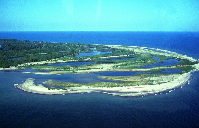
| Description | Aerial view of w:Presque Isle State Park, w:Erie, Pennsylvania. The photo is taken from the northeast and shows Gull Point in the foreground. Photo has some problems because of scanning. |
| Date | Unknown date |
| Source | http://www.fhwa.dot.gov/byways/photos/59490 |
| Author | Robert K. Grubbs; cleaned up and color-corrected by Howcheng |
| Permission ( Reusing this file) |
Released to public domain when submitted to the FHWA with 2005 nomination application. |
| Other versions | Original sample available at source URL. |
| Camera location |
| View this and other nearby images on: OpenStreetMap |
|
|---|
Licensing
| This work has been released into the
public domain by its author, Robert K. Grubbs. This applies worldwide. In some countries this may not be legally possible; if so: Robert K. Grubbs grants anyone the right to use this work for any purpose, without any conditions, unless such conditions are required by law.
|
File history
Click on a date/time to view the file as it appeared at that time.
| Date/Time | Thumbnail | Dimensions | User | Comment | |
|---|---|---|---|---|---|
| current | 17:47, 21 April 2006 |
| 2,871 × 1,854 (767 KB) | Holly Cheng | ==Summary== {{Information | Description=Aerial view of w:Presque Isle State Park, w:Erie, Pennsylvania. The photo is taken from the northeast and shows Gull Point in the foreground. Photo has some problems because of scanning. | Source=http://libr |
File usage
The following pages on the English Wikipedia use this file (pages on other projects are not listed):
- Lake Erie
- List of Pennsylvania state parks
- Presque Isle State Park
- User:Gerry D/archive6
- User:SandyGeorgia/Barnstars
- User:Trey/Barnstars
- User talk:Dwarf Kirlston/FAC Archive
- User talk:Finetooth/Archive 1
- User talk:Michael Devore/Archive 1
- User talk:Niagara/Archive 2
- User talk:Pnoble805
- User talk:SandyGeorgia/arch23
- User talk:TomStar81/Archive 4
- User talk:Tomdonohue1
- User talk:Trey/archive A
- User talk:VerruckteDan/Archive6
- User talk:YellowMonkey/Archive67
- Wikipedia:Main Page history/2017 November 18
- Wikipedia:Today's featured article/November 18, 2017
- Wikipedia:Today's featured article/November 2017
Global file usage
The following other wikis use this file:
- Usage on ca.wikipedia.org
- Usage on fr.wikipedia.org
- Usage on pl.wikipedia.org
- Usage on qu.wikipedia.org
- Usage on zh.wikipedia.org