
Size of this PNG preview of this SVG file:
736 × 599 pixels. Other resolutions:
295 × 240 pixels |
590 × 480 pixels |
943 × 768 pixels |
1,258 × 1,024 pixels |
2,516 × 2,048 pixels |
1,130 × 920 pixels.
Original file (SVG file, nominally 1,130 × 920 pixels, file size: 272 KB)
| This is a file from the
Wikimedia Commons. Information from its
description page there is shown below. Commons is a freely licensed media file repository. You can help. |
Summary
| Description |
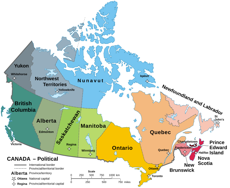
English: A map of Canada in its Provinces and territories Català: Mapa de les províncies i territoris del Canadà. |
||
| Date | |||
| Source | Localisation Manitoba.svg | ||
| Author | Hogweard | ||
| Permission ( Reusing this file) |
|
||
| Other versions |
Carte Politique du Canada.svg File:
Political map of Canada.svg has
1 translations.
|

File history
Click on a date/time to view the file as it appeared at that time.
| Date/Time | Thumbnail | Dimensions | User | Comment | |
|---|---|---|---|---|---|
| current | 11:58, 22 September 2023 |
| 1,130 × 920 (272 KB) | Lalpino | File uploaded using svgtranslate tool (https://svgtranslate.toolforge.org/). Added translation for ca. |
| 14:58, 14 October 2022 |
 | 1,130 × 920 (256 KB) | Enkhsaihan2005 | File uploaded using svgtranslate tool (https://svgtranslate.toolforge.org/). Added translation for mn. | |
| 00:43, 21 June 2022 |
 | 1,130 × 920 (211 KB) | -tynjee | File uploaded using svgtranslate tool (https://svgtranslate.toolforge.org/). Added translation for vi. | |
| 02:21, 23 August 2021 |
 | 1,130 × 920 (199 KB) | Praça de Maio | File uploaded using svgtranslate tool (https://svgtranslate.toolforge.org/). Added translation for tr. | |
| 01:59, 29 January 2021 |
 | 1,130 × 920 (161 KB) | Allice Hunter | Reverted to version as of 11:37, 19 October 2020 (UTC) | |
| 01:59, 29 January 2021 |
 | 512 × 424 (95 KB) | Allice Hunter | Largest cities | |
| 11:37, 19 October 2020 |
 | 1,130 × 920 (161 KB) | Hogweard | Fixed N&L label | |
| 08:48, 18 October 2020 |
 | 1,130 × 920 (161 KB) | Hogweard | {{Information |description=A map of Canada in its Provinces and territories |date=2020-10-18 |source={{f|Localisation_Manitoba.svg}} |author={{u|Hogweard}} |permission={{PD-self}} |other versions={{f|Carte Politique du Canada.svg}} }} Category:SVG maps of Canada Category:English language maps of Canada Category:Political maps of Canada |
File usage
The following pages on the English Wikipedia use this file (pages on other projects are not listed):
Global file usage
The following other wikis use this file:
- Usage on as.wikipedia.org
- Usage on azb.wikipedia.org
- Usage on bh.wikipedia.org
- Usage on br.wikipedia.org
- Usage on ca.wikipedia.org
- Usage on el.wikipedia.org
- Usage on io.wikipedia.org
- Usage on ku.wikipedia.org
- Usage on mdf.wikipedia.org
- Usage on mn.wikipedia.org
- Usage on my.wikipedia.org
- Usage on pa.wikipedia.org
- Usage on sq.wikipedia.org
- Usage on sr.wikipedia.org
- Usage on tl.wikipedia.org
- Usage on to.wikipedia.org
- Usage on tr.wikipedia.org
- Usage on uk.wikipedia.org
- Usage on vi.wikipedia.org