
Size of this PNG preview of this SVG file:
700 × 500 pixels. Other resolutions:
320 × 229 pixels |
640 × 457 pixels |
1,024 × 731 pixels |
1,280 × 914 pixels |
2,560 × 1,829 pixels.
Original file (SVG file, nominally 700 × 500 pixels, file size: 297 KB)
| This is a file from the
Wikimedia Commons. Information from its
description page there is shown below. Commons is a freely licensed media file repository. You can help. |
Summary
| Description |
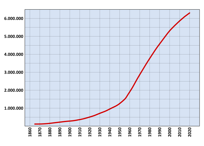
Español: Gráfico de población de la ciudad de
Santiago de Chile, capital de
Chile, entre
1860 y
2002 con proyección hasta
2020.
Los datos están basados en los censos nacionales entre 1860 y 2002. Para 1992, fueron considerados los habitantes de Santiago propiamente tal más Puente Alto y San Bernardo según el Informe de Ciudades, Pueblos y Aldeas (1992). Para 2002, se tomó el número de habitantes del Informe de Ciudades, Pueblos y Aldeas (2002). Las proyecciones realizadas desde 2002 hasta 2010 están basadas en las proyecciones realizadas por el Instituto Nacional de Estadísticas. Para ello, se ha calculado la población de las comunas de la Provincia de Santiago, más Padre Hurtado (prov. de Talagante), Pirque, Puente Alto, San José de Maipo (prov. de Cordillera) y San Bernardo (prov. de Maipo); para eliminar la población de las comunas incluidas pero que no pertenecen al área metropolitana se ha tomado el 95,4% del total (porcentaje de la población de Santiago en 2002 con respecto a la población total proyectada para el mismo año). |
| Date | |
| Source | Own work |
| Author | B1mbo |
Licensing
I, the copyright holder of this work, hereby publish it under the following licenses:

|
Permission is granted to copy, distribute and/or modify this document under the terms of the GNU Free Documentation License, Version 1.2 or any later version published by the Free Software Foundation; with no Invariant Sections, no Front-Cover Texts, and no Back-Cover Texts. A copy of the license is included in the section entitled GNU Free Documentation License. |
This file is licensed under the
Creative Commons Attribution-Share Alike
3.0 Unported,
2.5 Generic,
2.0 Generic and
1.0 Generic license.
- You are free:
- to share – to copy, distribute and transmit the work
- to remix – to adapt the work
- Under the following conditions:
- attribution – You must give appropriate credit, provide a link to the license, and indicate if changes were made. You may do so in any reasonable manner, but not in any way that suggests the licensor endorses you or your use.
- share alike – If you remix, transform, or build upon the material, you must distribute your contributions under the same or compatible license as the original.
You may select the license of your choice.
File history
Click on a date/time to view the file as it appeared at that time.
| Date/Time | Thumbnail | Dimensions | User | Comment | |
|---|---|---|---|---|---|
| current | 22:29, 26 August 2007 |
| 700 × 500 (297 KB) | B1mbo | Rasterized version and smooth graph... If you want to change the image use the previous version. |
| 22:19, 26 August 2007 |
 | 700 × 500 (20 KB) | B1mbo | {{Information |Description={{es|Gráfico de población de la ciudad de Santiago de Chile, capital de Chile, entre 1860 y 2002 con proyección hasta 2020. Los datos están basados en los censos nacionales entre 1860 y 2002. Para 1992, |
File usage
The following pages on the English Wikipedia use this file (pages on other projects are not listed):
Global file usage
The following other wikis use this file:
- Usage on ca.wikipedia.org
- Usage on es.wikipedia.org
- Usage on fj.wikipedia.org
- Usage on gl.wikipedia.org
- Usage on ka.wikipedia.org
- Usage on mt.wikipedia.org
- Usage on pt.wikipedia.org
- Usage on sq.wikipedia.org
- Usage on zh.wikipedia.org