North_River_(Hagstrom_map_of_Manhattan_1997).png (333 × 299 pixels, file size: 196 KB, MIME type: image/png)
| Description |
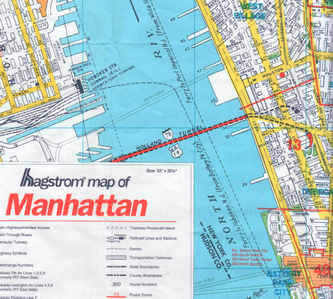
Detail of a Hagstrom map showing the use of the term "North River" to refer to the Hudson River between Hoboken and Lower Manhattan. |
|---|---|
| Source |
Hagstrom Borough of Manhattan, City of New York map, published 1997 |
| Date |
1997 |
| Author |
Hagstrom Map company |
| Permission ( Reusing this file) |
See below.
|
 | This work is
copyrighted (or assumed to be copyrighted) and unlicensed. It does not fall into one of the blanket acceptable non-free content categories listed at
Wikipedia:Non-free content § Images or
Wikipedia:Non-free content § Audio clips, and it is not covered by a more specific non-free content license listed at
Category:Wikipedia non-free file copyright templates. However, it is believed that the use of this work:
qualifies as
fair use under
United States copyright law. Any other uses of this image, on Wikipedia or elsewhere, may be
copyright infringement. See
Wikipedia:Non-free content and
Wikipedia:Copyrights. |
| Description |
Detail of a Hagstrom Borough of Manhattan, City of New York map, published 1997, showing lower portion of the Hudson River labeled as "North River". Includes minimal amount of surrounding area for context (making clear that its location is between Hoboken and Lower Manhattan). |
|---|---|
| Source |
Hagstrom Borough of Manhattan, City of New York map, published 1997 |
| Article | |
| Portion used |
Approx. 7"x7" section (4% of the entire map) |
| Low resolution? |
Yes (as low as possible with pertinent text still readable) |
| Purpose of use |
To demonstrate the Hagstrom Company's use of the term "North River" to refer to a portion of the Hudson River between Hoboken and Lower Manhattan |
| Replaceable? |
no |
| Fair use Fair use of copyrighted material in the context of North River (Hudson River)//en.wikipedia.org/wiki/File:North_River_(Hagstrom_map_of_Manhattan_1997).pngtrue | |
File history
Click on a date/time to view the file as it appeared at that time.
| Date/Time | Thumbnail | Dimensions | User | Comment | |
|---|---|---|---|---|---|
| current | 02:02, 27 May 2017 |
| 333 × 299 (196 KB) | DatBot ( talk | contribs) | Reduce size of non-free image ( BOT - disable) |
| 07:28, 18 January 2009 | No thumbnail | 550 × 494 (427 KB) | Father Goose ( talk | contribs) | On second thought, image can be reduced to 0.1 megapixel size with pertinent text still readable. |
You cannot overwrite this file.
.png&oldid=786998559)