Size of this preview:
654 × 600 pixels. Other resolutions:
262 × 240 pixels |
523 × 480 pixels |
837 × 768 pixels |
1,116 × 1,024 pixels |
2,233 × 2,048 pixels |
2,984 × 2,737 pixels.
Original file (2,984 × 2,737 pixels, file size: 7.6 MB, MIME type: image/jpeg)
| This is a file from the
Wikimedia Commons. Information from its
description page there is shown below. Commons is a freely licensed media file repository. You can help. |
Summary
| Description |
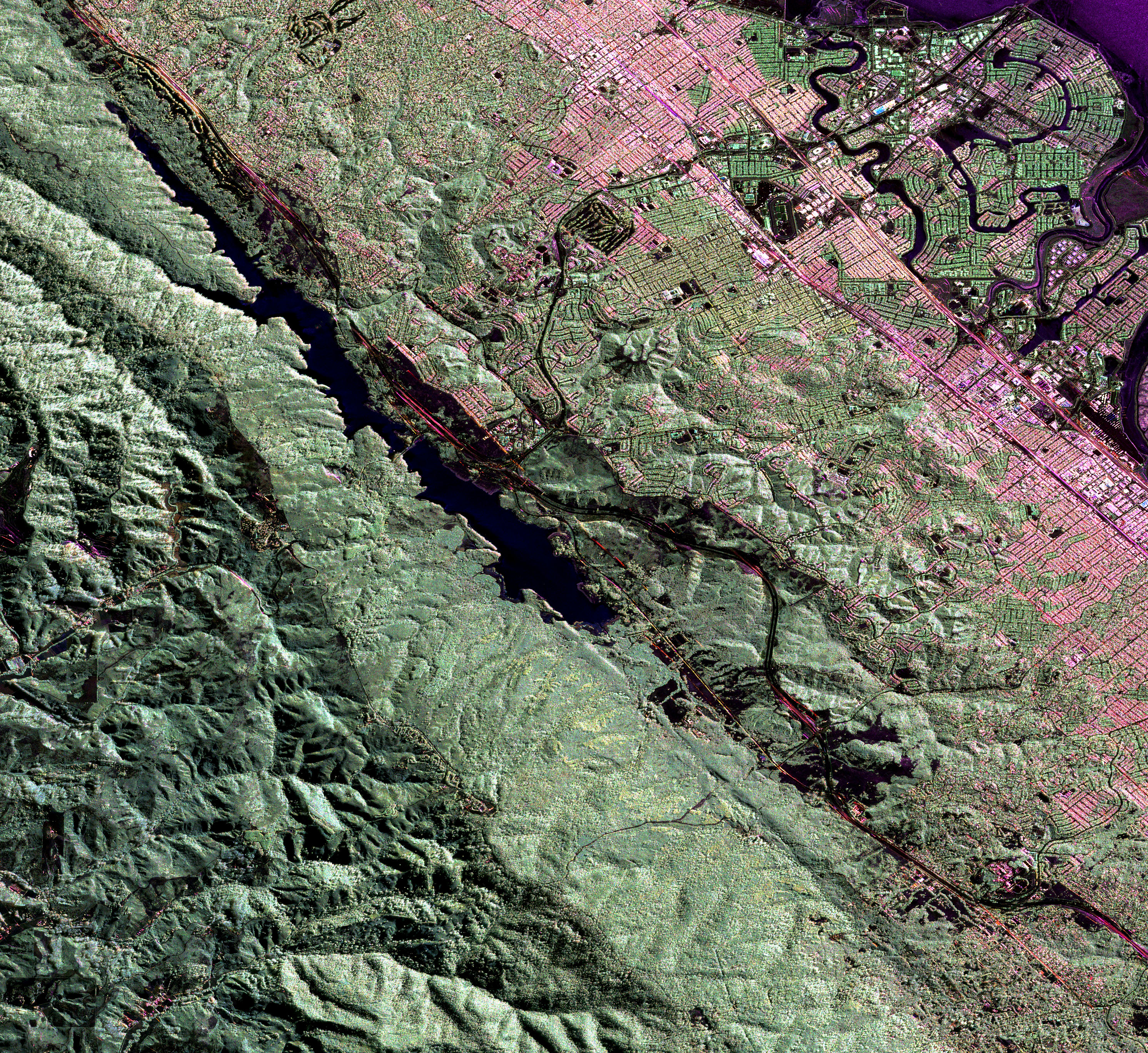
English: Much of the length of the San Andreas Fault is lined by a distinct trough. This false-colour radar image shows a section of the fault west of San Francisco Bay; the Crystal Springs Reservoir fills the trough that marks the underlying fault. The black line curving along the east side of the fault is I-280, and California highway 92 runs from the top right across to the centre left of the image, heading towards Half Moon Bay to the west. San Mateo and Burlingame are parts of the large urbanized area in various tones of pink and green, and Foster City is the area of curved streets extending out into the San Francisco Bay at the top right. |
| Date | |
| Source | NASA Earth Observatory |
| Author | Image courtesy of the NASA Jet Propulsion Laboratory. |
Instrument: Aircraft Sensors - UAVSARS
Licensing
| This file is in the public domain in the United States because it was solely created by NASA. NASA copyright policy states that "NASA material is not protected by copyright unless noted". (See Template:PD-USGov, NASA copyright policy page or JPL Image Use Policy.) | ||
 |
Warnings:
|
File history
Click on a date/time to view the file as it appeared at that time.
| Date/Time | Thumbnail | Dimensions | User | Comment | |
|---|---|---|---|---|---|
| current | 09:27, 23 June 2009 |
| 2,984 × 2,737 (7.6 MB) | Originalwana | {{Information |Description={{en|1=Much of the length of the San Andreas Fault is lined by a distinct trough. This false-colour radar image shows a section of the fault west of San Francisco Bay; the Crystal Springs Reservoir fills the trough that marks th |
File usage
The following pages on the English Wikipedia use this file (pages on other projects are not listed):
Global file usage
The following other wikis use this file:
- Usage on gl.wikipedia.org
- Usage on id.wikipedia.org
- Usage on simple.wikipedia.org