
Size of this preview:
505 × 599 pixels. Other resolutions:
202 × 240 pixels |
404 × 480 pixels |
647 × 768 pixels |
1,187 × 1,409 pixels.
Original file (1,187 × 1,409 pixels, file size: 940 KB, MIME type: image/jpeg)
| This is a file from the
Wikimedia Commons. Information from its
description page there is shown below. Commons is a freely licensed media file repository. You can help. |
Summary
| Description |
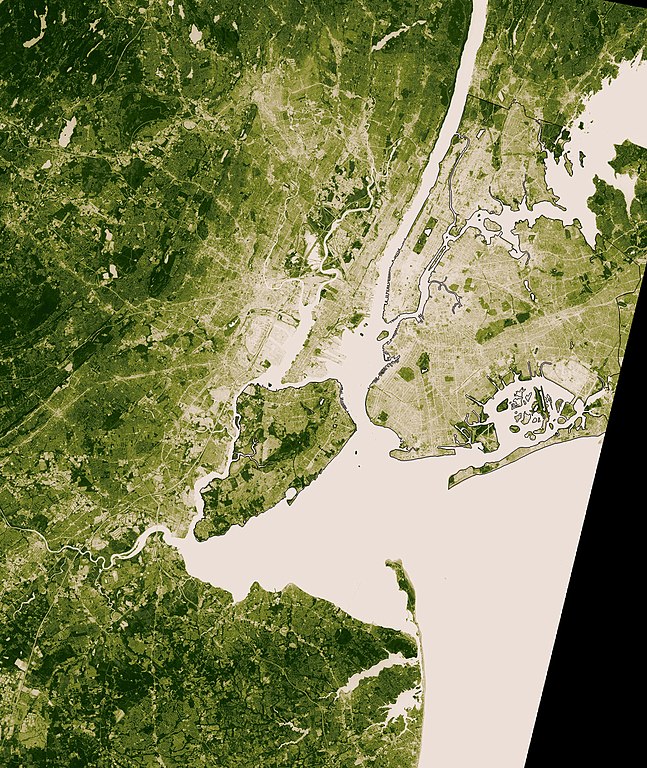
English: This image shows thermal infrared satellite data measured by NASA’s Landsat Enhanced Thematic Mapper Plus on August 14, one of the hottest days in New York?s 2002 summer. Landsat also collected vegetation data. The image shows vegetation from beige (sparse) to deep green (dense). |
| Source | [1] |
| Author | Image courtesy NASA/GSFC/MITI/ERSDAC/JAROS, and U.S./Japan ASTER Science Team |
Licensing
| This file is in the public domain in the United States because it was solely created by NASA. NASA copyright policy states that "NASA material is not protected by copyright unless noted". (See Template:PD-USGov, NASA copyright policy page or JPL Image Use Policy.) | ||
 |
Warnings:
|
Original upload log
The original description page was
here. All following user names refer to en.wikipedia.
- 2006-08-03 23:52 Wv235 1187×1409×8 (962400 bytes) This image shows thermal infrared satellite data measured by NASA?s Landsat Enhanced Thematic Mapper Plus on August 14, one of the hottest days in New York?s 2002 summer. Landsat also collected vegetation data. The image shows vegetation from beige (s
- 2006-08-03 23:50 Wv235 1187×1409×8 (962400 bytes) This image shows thermal infrared satellite data measured by NASA?s Landsat Enhanced Thematic Mapper Plus on August 14, one of the hottest days in New York?s 2002 summer. Landsat also collected vegetation data. The image shows vegetation from beige (s
- 2006-08-03 23:49 Wv235 1187×1409×8 (962400 bytes) This image shows thermal infrared satellite data measured by NASA?s Landsat Enhanced Thematic Mapper Plus on August 14, one of the hottest days in New York?s 2002 summer. Landsat also collected vegetation data. The image shows vegetation from beige (s
File history
Click on a date/time to view the file as it appeared at that time.
| Date/Time | Thumbnail | Dimensions | User | Comment | |
|---|---|---|---|---|---|
| current | 02:25, 6 December 2007 |
| 1,187 × 1,409 (940 KB) | File Upload Bot (Magnus Manske) | {{BotMoveToCommons|en.wikipedia}} {{Information |Description={{en|This image shows thermal infrared satellite data measured by NASA?s Landsat Enhanced Thematic Mapper Plus on August 14, one of the hottest days in New York?s 2002 summer. Landsat also coll |
File usage
The following pages on the English Wikipedia use this file (pages on other projects are not listed):
Global file usage
The following other wikis use this file:
- Usage on id.wikipedia.org
- Usage on ja.wikipedia.org