
Size of this preview:
680 × 599 pixels. Other resolutions:
272 × 240 pixels |
545 × 480 pixels |
872 × 768 pixels |
1,068 × 941 pixels.
Original file (1,068 × 941 pixels, file size: 135 KB, MIME type: image/png)
| This is a file from the
Wikimedia Commons. Information from its
description page there is shown below. Commons is a freely licensed media file repository. You can help. |

|
This map image could be re-created using
vector graphics as an
SVG file. This has several advantages; see
Commons:Media for cleanup for more information. If an SVG form of this image is available, please upload it and afterwards replace this template with
{{
vector version available|new image name}}
.
It is recommended to name the SVG file “Mexican Cession in Mexican View.svg”—then the template Vector version available (or Vva) does not need the new image name parameter. |
Summary
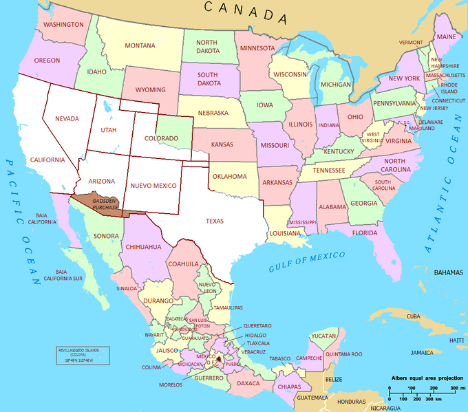
| Description | Mexican Cession in Mexican View |
| Date | 01/07/2009 |
| Source | U.S._Territorial_Acquisitions.png |
| Author | United States federal government (en:User:Black and White converted it from JPEG to PNG and retouched it) |
| Permission ( Reusing this file) |
This map was obtained from an edition of the National Atlas of the United States. Like almost all works of the U.S. federal government, works from the National Atlas are in the public domain. |
Licensing
| I, the copyright holder of this work, release this work into the
public domain. This applies worldwide. In some countries this may not be legally possible; if so: I grant anyone the right to use this work for any purpose, without any conditions, unless such conditions are required by law. |
File history
Click on a date/time to view the file as it appeared at that time.
| Date/Time | Thumbnail | Dimensions | User | Comment | |
|---|---|---|---|---|---|
| current | 21:02, 22 September 2011 |
| 1,068 × 941 (135 KB) | Hpav7 | ajustes |
| 04:39, 18 January 2010 |
 | 1,068 × 941 (135 KB) | Jaimiko | Se agrego la totalidad del territorio Mexicano y la division de los estados de Mexico. Was added the entire Mexican territory and the division of states of Mexico. | |
| 21:59, 1 July 2009 |
 | 1,066 × 721 (107 KB) | Jaimiko | {{Information |Description= Mexican Cession in Mexican View |Source= U.S._Territorial_Acquisitions.png |Date= 01/07/2009 |Author=United States federal government (en:User:Black and White converted it from JPEG to PNG and retouched it) |Permission=This map |
File usage
The following pages on the English Wikipedia use this file (pages on other projects are not listed):
Global file usage
The following other wikis use this file:
- Usage on af.wikipedia.org
- Usage on ca.wikipedia.org
- Usage on cs.wikipedia.org
- Usage on de.wikipedia.org
- Usage on es.wikipedia.org
- Usage on fa.wikipedia.org
- Usage on fi.wikipedia.org
- Usage on fr.wikipedia.org
- Usage on hr.wikipedia.org
- Usage on hu.wikipedia.org
- Usage on it.wikipedia.org
- Usage on ja.wikipedia.org
- Usage on ms.wikipedia.org
- Usage on sh.wikipedia.org
- Usage on ta.wikipedia.org
- Usage on th.wikipedia.org
- Usage on zh-min-nan.wikipedia.org
- Usage on zh.wikipedia.org