
Size of this preview:
800 × 530 pixels. Other resolutions:
320 × 212 pixels |
640 × 424 pixels |
1,024 × 678 pixels |
1,280 × 847 pixels |
2,328 × 1,541 pixels.
Original file (2,328 × 1,541 pixels, file size: 2.81 MB, MIME type: image/png)
| This is a file from the
Wikimedia Commons. Information from its
description page there is shown below. Commons is a freely licensed media file repository. You can help. |
Summary
| Description |
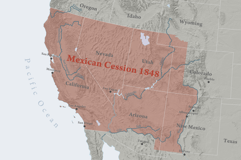
English: Map of the
Mexican Cession.
|
||||||||
| Date | |||||||||
| Source | Own work | ||||||||
| Author | Kballen | ||||||||
| Permission ( Reusing this file) |
I, the copyright holder of this work, hereby publish it under the following licenses:
This file is licensed under the
Creative Commons
Attribution 3.0 Unported license.
You may select the license of your choice. |

File history
Click on a date/time to view the file as it appeared at that time.
| Date/Time | Thumbnail | Dimensions | User | Comment | |
|---|---|---|---|---|---|
| current | 01:56, 14 April 2008 |
| 2,328 × 1,541 (2.81 MB) | Kballen | ({{Information |Description= Region ceded to the United States of America by Mexico in 1848. |Source= Self made. Boundary source is National Atlas of the United States. |Date= April 13, 2008 |Author= Kballen |Permission= |other_versions= }} ) |
| 01:43, 14 April 2008 |
 | 2,328 × 1,541 (2.81 MB) | Kballen | {{Information |Description= Region ceded to the United States of America by Mexico in 1848. |Source= Self made. Boundary source is National Atlas of the United States. |Date= April 13, 2008 |Author= Kballen |Permission= |other_versions= | |
| 23:08, 6 April 2008 |
 | 2,328 × 1,541 (2.41 MB) | Kballen | {{Information |Description= Region ceded to the United States of America by Mexico in 1848. |Source=self-made |Date= April 6, 2008 |Author= Kballen |Permission= |other_versions= }} |
File usage
The following pages on the English Wikipedia use this file (pages on other projects are not listed):
Global file usage
The following other wikis use this file:
- Usage on af.wikipedia.org
- Usage on ca.wikipedia.org
- Usage on cs.wikipedia.org
- Usage on da.wikipedia.org
- Usage on de.wikipedia.org
- Usage on fa.wikipedia.org
- Usage on id.wikipedia.org
- Usage on it.wikipedia.org
- Usage on la.wikipedia.org
- Usage on pl.wikipedia.org
- Usage on pt.wikipedia.org
- Usage on ro.wikipedia.org
- Usage on sv.wikipedia.org
- Usage on ur.wikipedia.org
- Usage on vi.wikipedia.org