
Size of this preview:
800 × 559 pixels. Other resolutions:
320 × 223 pixels |
640 × 447 pixels |
1,024 × 715 pixels |
1,173 × 819 pixels.
Original file (1,173 × 819 pixels, file size: 208 KB, MIME type: image/png)
| This is a file from the
Wikimedia Commons. Information from its
description page there is shown below. Commons is a freely licensed media file repository. You can help. |

|
This map image could be re-created using
vector graphics as an
SVG file. This has several advantages; see
Commons:Media for cleanup for more information. If an SVG form of this image is available, please upload it and afterwards replace this template with
{{
vector version available|new image name}}
.
It is recommended to name the SVG file “Maritime Fur Trade-NorthWestCoast.svg”—then the template Vector version available (or Vva) does not need the new image name parameter. |
Summary
| Description |
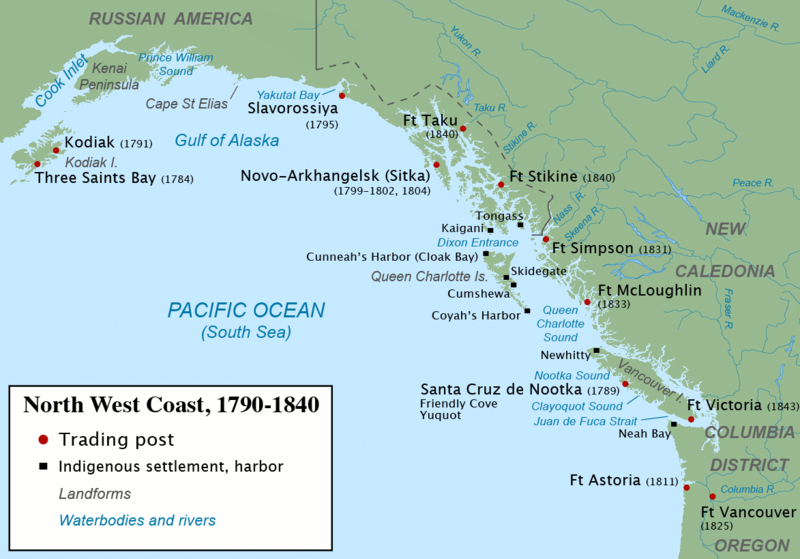
English: Map of the North West Coast during the
Maritime Fur Trade era, circa 1790 to 1840. Main sources consulted include:
|
| Date | |
| Source | Own work |
| Author | Pfly |
Licensing
I, the copyright holder of this work, hereby publish it under the following licenses:
This file is licensed under the
Creative Commons
Attribution-Share Alike 3.0 Unported license.
- You are free:
- to share – to copy, distribute and transmit the work
- to remix – to adapt the work
- Under the following conditions:
- attribution – You must give appropriate credit, provide a link to the license, and indicate if changes were made. You may do so in any reasonable manner, but not in any way that suggests the licensor endorses you or your use.
- share alike – If you remix, transform, or build upon the material, you must distribute your contributions under the same or compatible license as the original.

|
Permission is granted to copy, distribute and/or modify this document under the terms of the GNU Free Documentation License, Version 1.2 or any later version published by the Free Software Foundation; with no Invariant Sections, no Front-Cover Texts, and no Back-Cover Texts. A copy of the license is included in the section entitled GNU Free Documentation License. |
You may select the license of your choice.
File history
Click on a date/time to view the file as it appeared at that time.
| Date/Time | Thumbnail | Dimensions | User | Comment | |
|---|---|---|---|---|---|
| current | 15:48, 8 December 2017 |
| 1,173 × 819 (208 KB) | PawełMM | Cropped 2 % horizontally and 3 % vertically using CropTool with precise mode. Border removed |
| 20:24, 17 February 2013 |
 | 1,199 × 848 (207 KB) | JohnnyMrNinja | indexed colors and increased compression | |
| 07:14, 7 May 2010 |
 | 1,199 × 848 (567 KB) | Pfly | Fix photoshop mistake in previous edit, argh! | |
| 07:11, 7 May 2010 |
 | 1,243 × 878 (609 KB) | Pfly | Fixed date error for Fort Taku. | |
| 16:25, 15 April 2010 |
 | 1,215 × 859 (585 KB) | Pfly | {{Information |Description={{en|1=Map of the North West Coast during the Maritime Fur Trade era, circa 1790 to 1840. Main sources consulted include: * Gibson, James R. (1992). Otter Skins, Boston Ships, and China Goods: The Ma |
File usage
The following pages on the English Wikipedia use this file (pages on other projects are not listed):
Global file usage
The following other wikis use this file:
- Usage on ca.wikipedia.org
- Usage on de.wikipedia.org
- Usage on es.wikipedia.org
- Usage on lt.wikipedia.org
- Usage on pt.wikipedia.org
- Usage on tr.wikipedia.org