
Size of this preview:
800 × 531 pixels. Other resolutions:
320 × 212 pixels |
640 × 425 pixels |
1,000 × 664 pixels.
Original file (1,000 × 664 pixels, file size: 281 KB, MIME type: image/jpeg)
| This is a file from the
Wikimedia Commons. Information from its
description page there is shown below. Commons is a freely licensed media file repository. You can help. |
Summary
| Description |
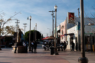
Boyle Heights, where the Mexican influence of East Los Angeles continues to predominate, though there is a bit of Japanese presence from Little Tokyo across the Los Angeles River. Two underground Metro Gold Line stations, Soto and Mariachi Plaza, serve the neighborhood. Here at Mariachi Plaza, it's all Mexican. In fact, there are several mariachi bands from Michoacan, Mexico, who are available for hire, as seen here. The statue commemorates Lucha Reyes (1906-1944), a Mexican singer who was best known for singing the Ranchera Song. |
| Date | |
| Source | Mariachi Plaza |
| Author | InSapphoWeTrust from Los Angeles, California, USA |
| Other versions |
_(cropped).jpg)
.jpg)
| Camera location |
| View this and other nearby images on: OpenStreetMap |
|
|---|
.jpg¶ms=034.047638_N_-118.219757_E_globe:Earth_type:camera_source:Flickr_&language=en)
Licensing
This file is licensed under the
Creative Commons
Attribution-Share Alike 2.0 Generic license.
- You are free:
- to share – to copy, distribute and transmit the work
- to remix – to adapt the work
- Under the following conditions:
- attribution – You must give appropriate credit, provide a link to the license, and indicate if changes were made. You may do so in any reasonable manner, but not in any way that suggests the licensor endorses you or your use.
- share alike – If you remix, transform, or build upon the material, you must distribute your contributions under the same or compatible license as the original.
| This image, originally posted to Flickr, was reviewed on 27 January 2013 by the administrator or reviewer File Upload Bot (Magnus Manske), who confirmed that it was available on Flickr under the stated license on that date. |
File history
Click on a date/time to view the file as it appeared at that time.
| Date/Time | Thumbnail | Dimensions | User | Comment | |
|---|---|---|---|---|---|
| current | 16:52, 27 January 2013 |
| 1,000 × 664 (281 KB) | File Upload Bot (Magnus Manske) | Transferred from Flickr by User:russavia |
File usage
The following pages on the English Wikipedia use this file (pages on other projects are not listed):
Global file usage
The following other wikis use this file:
- Usage on azb.wikipedia.org
- Usage on es.wikipedia.org
- Usage on www.wikidata.org
.jpg)