
Size of this PNG preview of this SVG file:
800 × 367 pixels. Other resolutions:
320 × 147 pixels |
640 × 294 pixels |
1,024 × 470 pixels |
1,280 × 587 pixels |
2,560 × 1,175 pixels |
900 × 413 pixels.
Original file (SVG file, nominally 900 × 413 pixels, file size: 647 KB)
| This is a file from the
Wikimedia Commons. Information from its
description page there is shown below. Commons is a freely licensed media file repository. You can help. |
Summary
| Description |
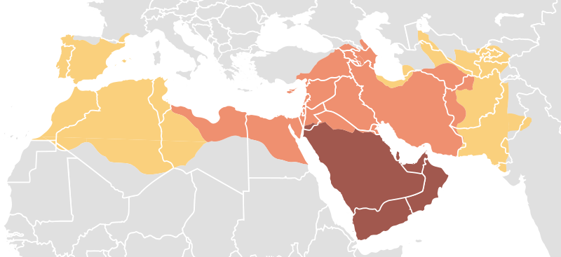
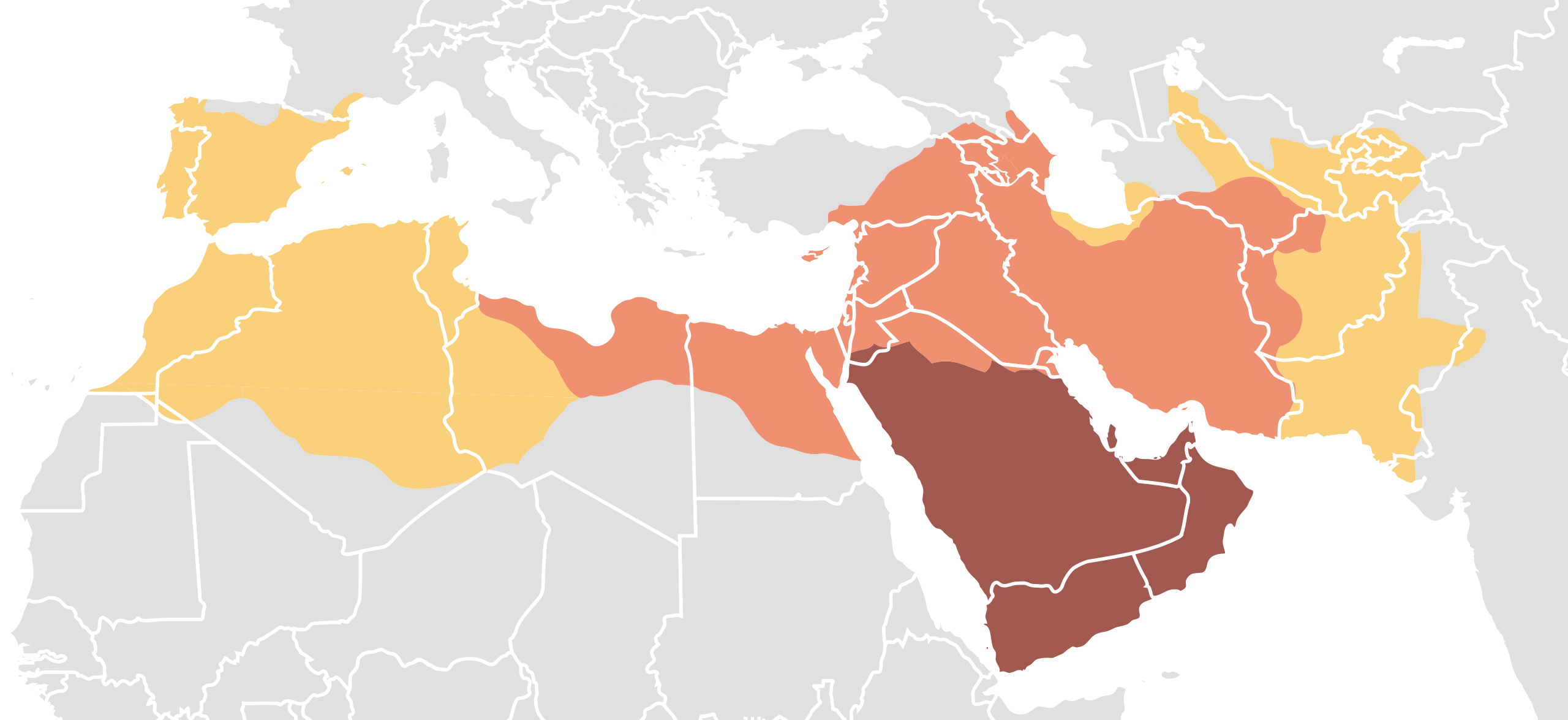
العربية:
توسع الدولة الإسلامية في عهد محمد ، ٦٢٢-٦٣٢
توسع الدولة الإسلامية في عهد الخلفاء الراشدين ، ٦٣٢-٦٦١
توسع الدولة الإسلامية في عهد الخلفاء الأمويين ، ٦٦١-٧٥٠ فارسی:
گسترش قلمرو اسلام در زمان محمدؐ ، ۶۲۲-۶۳۲
گسترش قلمرو اسلام در زمان خلفای راشدین ، ۶۳۲-۶۶۱
گسترش قلمرو اسلام در زمان خلفای اموی ، ۶۶۱-۷۵۰ اردو:
اسلامی ریاست کی وسعت محمدؐ کے عہد میں ، ۶۲۲-۶۳۲
اسلامی ریاست کی وسعت خلفائے راشدين کے عہد میں ، ۶۳۲-۶۶۱
اسلامی ریاست کی وسعت امویوں کے عہد میں ، ۶۶۱-۷۵۰ پښتو:
د اسلامی ریاست وسعت د محمدؐ پہ عہد کی ، ۶۲۲-۶۳۲
د اسلامی ریاست وسعت د الخلفاء الراشدين پہ عہد کی ، ۶۳۲-۶۶۱
د اسلامی ریاست وسعت د الامویین پہ عہد کی ، ۶۶۱-۷۵۰ বাংলা:
৬২২ থেকে ৬৩২ খ্রিস্টাব্দ পর্যন্ত
মুহাম্মাদ অধীনে ইসলামের সম্প্রসারণ।
৬৩২ থেকে ৬৬১ খ্রিস্টাব্দ পর্যন্ত
রাশিদুন খিলাফতের অধীনে ইসলামের সম্প্রসারণ।
৬৬১ থেকে ৭৫০ খ্রিস্টাব্দ পর্যন্ত
উমাইয়া খিলাফতের অধীনে ইসলামের সম্প্রসারণ। Български: Разширения на Арабския алифат
Разширяване при
Мохамед, 622-632
Разширяване по времето на
Праведния Халифат, 632-661
Разширения при
Умаядите, 661-750 Čeština: Období chalífátu
hranice za vlády Mohameda, 622-632
hranice za vlády volených chalífů, 632-661
hranice za vlády Umajjovců, 661-750 Deutsch: Zeit der Kalifen:
Ausbreitung unter Mohammed, 622-632
Ausbreitung unter den vier „rechtgeleiteten Kalifen“, 632-661
Ausbreitung unter den Umayyaden, 661-750 English: Age of the Caliphs
Expansion under Muhammad, 622-632
Expansion during the Rashidun Caliphate, 632-661
Expansion during the Umayyad Caliphate, 661-750
Shows modern borders.Esperanto: Epoko de la kalifoj:
ekspansio en la epoko de Mohamedo, 622-632
ekspansio en la epoko de la "kvar justaj kalifoj", 632-661
ekspansio en la epoko de la Umajidoj, 661-750 Español: Expansión de los diferentes califas
Expansión en la época de Mahoma, 622-632
Expansión durante el Califato Ortodoxo, 632-661
Expansión durante el Califato Omeya, 661-750 Français : Empire arabe
Expansion à l'époque de Mahomet, 622-632
Expansion durant les quatre premiers califes, 632-661
Expansion sous la dynastie Omeyyade, 661-750 Italiano:
Espansione sotto Maometto, 622-632
Espansione durante il Califfato Patriarcale, 632-661
Espansione durante il Califfato Omayyade, 661-750 Português: Era dos Califas
Expansão durante a época de
Maomé, 622-632
Expansão durante o
Califado Rashidun, 632-661
Expansão durante o
Califado Omíada, 661-750 Română:
Expansiunea sub Mohamed, 622-632
Expansiunea în timpul primelor patru califate, 632-661
Expansiunea în timpul Califatului Umayyad, 661-750 Русский:
Расширение халифата во время правления Мухаммеда, 622-632
Расширение халифата во время правления первых четырёх халифов, 632-661
Расширение халифата во время правления династии Омейядов, 661-750 Soomaaliga: Xiligii Khulafad SRC
Xiligii Muhammad, 622-632
Xiligii Khuladafaa'u Raashidiinka, 632-661
Xiligii Umawiyiinta, 661-750 Türkçe: Halifeler Devri
Muhammed dönemindeki genişleme, 622-632
Dört Halife dönemindeki genişleme, 632-661
Emevi halifeliği dönemindeki genişleme, 661-750 Українська: Епоха халіфів
Завоювання за часів Мухаммеда, 622-632
Завоювання за часів Праведного Халіфату, 632-661
Завоювання за часів Омейядів, 661-750 中文:阿拉伯帝国的扩张
穆罕默德领导下的扩张,622-632
四大哈里发时期的疆域,632-661
倭马亚王朝王朝时期的疆域,661-750 |
||
| Date | |||
| Source |
Own work using:
|
||
| Author | DieBuche | ||
| Permission ( Reusing this file) |
|
||
| Other versions | Derivative works of this file: Map of expansion of Caliphate-pt.svg Image:Age_of_Caliphs.png | ||
| SVG development | This
vector image was created with
Inkscape, or with something else. |
File history
Click on a date/time to view the file as it appeared at that time.
| Date/Time | Thumbnail | Dimensions | User | Comment | |
|---|---|---|---|---|---|
| current | 18:16, 27 August 2022 |
| 900 × 413 (647 KB) | FanofMultimedia123 | Reverted to version as of 18:07, 20 March 2022 (UTC) It shows the largest territorial expansion from the Umayyads. |
| 05:47, 5 July 2022 |
 | 900 × 413 (611 KB) | Dev0745 | Reverted to version as of 20:29, 21 November 2016 (UTC) other south show former map|Source= * http://www.shadowedrealm.com/maps/political/view/the_caliphate * http://www.shadowedrealm.com/maps/political/ |Author=Sheperd, William R.; Historical Atlas; New York: Henry Holt and Company, 1911. 53. |Date=1911 map by William R. Shepherd (12 June 1871 – 7 June 1934). | |
| 18:07, 20 March 2022 |
 | 900 × 413 (647 KB) | The Story of Marjaan | Added the conquered parts in Northwestern India by Muhammad bin Qasim. The map can be found on File:QASIM.PNG. It depicts the largest extent of the territory conquered by Qasim during the Umayyads. | |
| 20:29, 21 November 2016 |
 | 900 × 413 (611 KB) | Sémhur | Valid SVG | |
| 06:14, 22 November 2012 |
 | 900 × 413 (587 KB) | Tariq ibn Ziyad | Adjustments according to the original source. http://www.gl.iit.edu/govdocs/maps/Middle%20East-Age%20of%20the%20Caliphs.gif | |
| 21:29, 13 November 2012 |
 | 900 × 413 (588 KB) | Sammy pompon | Narbona and part of Languedoc were part of the omeyas. | |
| 20:17, 26 January 2012 |
 | 900 × 413 (572 KB) | Sémhur | Adding South Sudan border | |
| 19:15, 4 July 2010 |
 | 900 × 413 (558 KB) | DieBuche | Increase size | |
| 19:10, 4 July 2010 |
 | 225 × 113 (507 KB) | DieBuche | {{ShouldBeSVG|map}} == Legend == ===Arabic=== {{legend|#a1584e|توسع الدولة الإسلامية في عهد محمد صلى الله علية وسلم, 612-632}} {{legend|#ef9070|توسع الدولة الإسلامية في عهد الخلفاء |
File usage
The following pages on the English Wikipedia use this file (pages on other projects are not listed):
- 661
- Abbasid Caliphate
- Al-Andalus
- Arab-Chalukya conflict
- Arab identity
- Arab studies
- Arabization
- Arab–Byzantine wars
- Byzantine Empire under the Heraclian dynasty
- Byzantine North Africa
- Caliphate
- Caliphate of Córdoba
- Chalukyas of Navasarika
- Christianity in the 7th century
- Christianity in the 8th century
- Early Middle Ages
- Early Muslim conquests
- Egypt in the Middle Ages
- Fatimid Caliphate
- Growth of religion
- History of Azerbaijan
- History of Iran
- History of Iraq
- History of Pakistan
- History of Palestine
- History of Tajikistan
- History of Uzbekistan
- History of early Islamic Tunisia
- History of the Arabs
- History of the Mediterranean region
- History of the Middle East
- Incense trade route
- Indo-Roman trade relations
- Islam in Central Asia
- Islam in Iran
- Islam in Turkey
- Islamic Golden Age
- Jihad
- List of countries and territories where Arabic is an official language
- Medieval Muslim Algeria
- Middle Ages
- Military history of Iran
- Muhammad
- Muhammad ibn al-Qasim
- Ottoman Caliphate
- Political aspects of Islam
- Pre-Islamic Arabia
- Rashidun Caliphate
- Science in the medieval Islamic world
- Slavery in medieval Europe
- Sokoto Caliphate
- Spread of Islam
- Succession to Muhammad
- Timeline of Jerusalem
- Tribes of Arabia
- Typos of Constans
- Umayyad Caliphate
- User:2know4power/sandbox
- User:Albertatiran/sandbox10
- User:Antisyntagmatarchos/Byzantine North Africa
- User:BomBom/List of caliphs
- User:Falcaorib
- User:Grapeguy/sandbox/
- User:Lingzhi/anothersandbox
- User:Northamerica1000/Topics
- User:Thecatcherintherye/Sandbox
- User:রিজওয়ান আহমেদ/Muhammad
- Template:Caliphate
- Template talk:Tmbox/Archive 2
- Template talk:Tmbox/examples/stacknocolour
- Portal:Azerbaijan
- Portal:History of science
- Portal:Iran
- Portal:Iraq
Global file usage
The following other wikis use this file:
- Usage on af.wikipedia.org
- Usage on ar.wikipedia.org
- عرب
- الوطن العربي
- فتوحات إسلامية
- ثيوقراطية
- حزب التحرير
- خلافة إسلامية
- العصور الوسطى
- خليفة
- تاريخ الشرق الأوسط
- قائمة الخلفاء
- تاريخ ليبيا
- الخلافة العثمانية
- تاريخ إيران
- قالب:خلافة
- الخلافة الراشدة
- تاريخ اليمن الإسلامي
- تاريخ الجزائر
- محمد
- الدولة الفاطمية
- تعريب (سياسة)
- تاريخ أوزبكستان
- مستخدم:خالد/عرب/التاريخ
- مستخدم:خالد/عرب
- الإسلام في وسط آسيا
- قائمة أكبر الإمبراطوريات
- بوابة:العالم الإسلامي/مقالة مختارة/أرشيف
- بوابة:العالم الإسلامي/مقالة مختارة/18
- بوابة:المتوسط
- بوابة:المتوسط/صورة متوسطية
- بوابة:المتوسط/صورة متوسطية/2
- قالب:وسام الفتوحات الإسلامية
- تاريخ منطقة البحر المتوسط
- مستخدم:محمد رشاد ابوالنجا/Early Muslim conquests
- مستخدم:محمد رشاد ابوالنجا/Spread of Islam
- تاريخ العرب
- مستخدم:Ahmad ali serhan/المسيحية في القرن السابع ميلادي
- المسيحية في القرن السابع ميلادي
- مازون
- دراسات عربية
- Usage on ar.wikiquote.org
- Usage on ary.wikipedia.org
- Usage on arz.wikipedia.org
- Usage on ast.wikipedia.org
View more global usage of this file.