No higher resolution available.
MajorVolcanoesOfThePhilippines-USGS.gif (336 × 594 pixels, file size: 18 KB, MIME type: image/gif)
| This is a file from the
Wikimedia Commons. Information from its
description page there is shown below. Commons is a freely licensed media file repository. You can help. |
| Description |
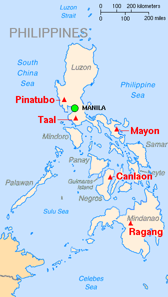
English: Map showing major volcanoes of the Philippines Français : Carte des principaux volcans aux
Philippines |
|||
| Date | ||||
| Source | Archived source link | |||
| Author | Lyn Topinka, base map from CIA, volcanoes from Simkin and Siebert | |||
| Permission ( Reusing this file) |
|
|||
| Other versions |
|

File history
Click on a date/time to view the file as it appeared at that time.
| Date/Time | Thumbnail | Dimensions | User | Comment | |
|---|---|---|---|---|---|
| current | 13:10, 16 February 2014 |
| 336 × 594 (18 KB) | Hike395 | Crop title, logo, credit line |
| 14:48, 8 August 2006 |
 | 351 × 752 (24 KB) | PFHLai | {{Information |Description= Map showing major volcanoes of the Philippines |Source= http://vulcan.wr.usgs.gov/Imgs/Gif/Philippines/Maps/map_philippines_volcanoes.gif on http://vulcan.wr.usgs.gov/Volcanoes/Philippines/Maps/map_philippines_volcanoes.html |D |
File usage
The following pages on the English Wikipedia use this file (pages on other projects are not listed):
Global file usage
The following other wikis use this file:
- Usage on ast.wikipedia.org
- Usage on ca.wikipedia.org
- Usage on cs.wikipedia.org
- Usage on de.wikipedia.org
- Usage on es.wikipedia.org
- Usage on fr.wikinews.org
- Usage on gl.wikipedia.org
- Usage on hr.wikipedia.org
- Usage on id.wikipedia.org
- Usage on ilo.wikipedia.org
- Usage on it.wikipedia.org
- Usage on ja.wikipedia.org
- Usage on la.wikipedia.org
- Usage on mk.wikipedia.org
- Usage on ms.wikipedia.org
- Usage on nn.wikipedia.org
- Usage on no.wikipedia.org
- Usage on pam.wikipedia.org
- Usage on pt.wikipedia.org
- Usage on sh.wikipedia.org
- Usage on sl.wikipedia.org
- Usage on sq.wikipedia.org
- Usage on tl.wikipedia.org
- Usage on tr.wikipedia.org
- Usage on uk.wikipedia.org
- Usage on vi.wikipedia.org
- Usage on zh.wikipedia.org