Size of this preview:
778 × 600 pixels. Other resolutions:
311 × 240 pixels |
623 × 480 pixels |
1,000 × 771 pixels.
Original file (1,000 × 771 pixels, file size: 1.44 MB, MIME type: image/png)
| This is a file from the
Wikimedia Commons. Information from its
description page there is shown below. Commons is a freely licensed media file repository. You can help. |
Summary
| Description |
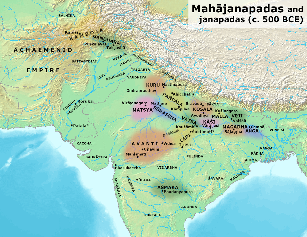
English: Map of places mentioned in ancient Buddhist Texts (like Anguttara Nikaya), Ramayana and Mahabharata.
Sources:
|
||
| Date | |||
| Source | Own work | ||
| Author | Avantiputra7 | ||
| Other versions |
|

.png)
Licensing
I, the copyright holder of this work, hereby publish it under the following license:
This file is licensed under the
Creative Commons
Attribution-Share Alike 3.0 Unported license.
- You are free:
- to share – to copy, distribute and transmit the work
- to remix – to adapt the work
- Under the following conditions:
- attribution – You must give appropriate credit, provide a link to the license, and indicate if changes were made. You may do so in any reasonable manner, but not in any way that suggests the licensor endorses you or your use.
- share alike – If you remix, transform, or build upon the material, you must distribute your contributions under the same or compatible license as the original.
File history
Click on a date/time to view the file as it appeared at that time.
| Date/Time | Thumbnail | Dimensions | User | Comment | |
|---|---|---|---|---|---|
| current | 04:32, 19 May 2020 |
| 1,000 × 771 (1.44 MB) | Avantiputra7 | a few more labels |
| 18:44, 9 May 2020 |
 | 1,000 × 771 (1.43 MB) | Avantiputra7 | added some more labels from Schwartzberg | |
| 15:23, 7 May 2020 |
 | 1,000 × 771 (1.42 MB) | Avantiputra7 | minor fix | |
| 15:19, 7 May 2020 |
 | 1,000 × 771 (1.42 MB) | Avantiputra7 | more readable font | |
| 12:34, 17 November 2017 |
 | 1,200 × 889 (1.85 MB) | Avantiputra7 | labelled Mahismati, & Chakrabarti 2000: identification of Suktimati with Rewa | |
| 09:01, 8 September 2017 |
 | 1,200 × 889 (1.85 MB) | Avantiputra7 | Updated with colors reflecting approximate extent of realms | |
| 02:48, 5 June 2014 |
 | 1,200 × 889 (1.87 MB) | Avantiputra7 | User created page with UploadWizard |
File usage
The following pages on the English Wikipedia use this file (pages on other projects are not listed):
- Anga
- Asmaka
- Avanti (region)
- Bhagga
- Bihar
- Brāhmaṇa (tribe)
- Buddhism
- Buli (tribe)
- Cedī (tribe)
- Daṇḍaka
- Early Buddhist texts
- Gandhara
- Gandhāra (kingdom)
- Gaṇasaṅgha
- History of Bengal
- History of Buddhism
- History of India
- History of Jharkhand
- History of Odisha
- History of Punjab
- History of Sindh
- History of democracy
- Indo-European migrations
- Kekaya
- Koliya
- Kosala
- Kosala Kingdom
- Kuru Kingdom
- Kālāma
- Kāśī (kingdom)
- Licchavis of Vaishali
- List of ancient Indo-Aryan peoples and tribes
- List of rulers of Bengal
- Madra
- Magadha
- Magadha-Anga war
- Mahajanapadas
- Mahavira
- Mahishmati
- Malla (tribe)
- Matsya (tribe)
- Military history of India
- Moriya (tribe)
- Nāya
- Pañcāla
- Pradyota dynasty
- Pre-sectarian Buddhism
- Pulinda
- Republic
- Shakya
- Shivi
- Sindhu-Sauvīra
- Sumedha
- Surasena
- The Buddha
- Trigarta Kingdom
- Uśīnara
- Vaishali (ancient city)
- Vajji (tribe)
- Vajjika League
- Vanga Kingdom
- Vatsa
- Vidarbha (kingdom)
- Virata Kingdom
- Ānanda
- Āndhra (tribe)
- User:Joshua Jonathan/Spread of Vedic culture
- User:Joshua Jonathan/Tools
- User:Կիմա34/sandbox
- User talk:Avantiputra7
- User talk:Kautilya3/Archives/Archive 1
Global file usage
The following other wikis use this file:
- Usage on af.wikipedia.org
- Usage on ar.wikipedia.org
- Usage on as.wikipedia.org
- Usage on azb.wikipedia.org
- Usage on bh.wikipedia.org
- Usage on bn.wikipedia.org
- বাংলাদেশ
- পশ্চিমবঙ্গ
- গৌতম বুদ্ধ
- মহাবীর
- বাংলাদেশের ইতিহাস
- মৌর্য সাম্রাজ্য
- বাংলার ইতিহাস
- বঙ্গ রাজ্য
- পাঞ্চাল
- অবন্তী
- নন্দ সাম্রাজ্য
- গান্ধার
- শূরসেন রাজ্য
- মল্ল রাজ্য
- কুরু রাজ্য
- অশ্মক রাজ্য
- চেদি রাজ্য
- কোশল রাজ্য
- গণতন্ত্রের ইতিহাস
- বৎস রাজ্য
- ঝাড়খণ্ডের ইতিহাস
- বাংলার শাসকগণ
- ত্রিগর্ত রাজ্য
- মদ্র
- অপরন্ত
- চেদী (উপজাতি)
- Usage on ca.wikipedia.org
- Usage on ceb.wikipedia.org
- Usage on ce.wikipedia.org
- Usage on cs.wikipedia.org
- Usage on cy.wikipedia.org
- Usage on de.wikipedia.org
View more global usage of this file.
.png)
.png)