
Size of this preview:
800 × 368 pixels. Other resolutions:
320 × 147 pixels |
640 × 294 pixels |
1,024 × 471 pixels |
2,167 × 996 pixels.
Original file (2,167 × 996 pixels, file size: 970 KB, MIME type: image/jpeg)
| This is a file from the
Wikimedia Commons. Information from its
description page there is shown below. Commons is a freely licensed media file repository. You can help. |
|
This is an image of a place or building that is listed on the
National Register of Historic Places in the
United States of America. Its reference number is
92000756. |
Summary
| Description |
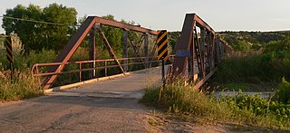
English:
Lewellen State Aid Bridge, carrying county road 199A across the
North Platte River south of
Lewellen, Nebraska; seen from the south (downstream is east). The bridge consists of seven
Pratt pony truss spans. Constructed in 1926, it is listed in the
National Register of Historic Places. |
| Date | |
| Source | Own work |
| Author | Ammodramus |
| Object location |
| View this and other nearby images on: OpenStreetMap |
|
|---|
Licensing
| I, the copyright holder of this work, release this work into the
public domain. This applies worldwide. In some countries this may not be legally possible; if so: I grant anyone the right to use this work for any purpose, without any conditions, unless such conditions are required by law. |
File history
Click on a date/time to view the file as it appeared at that time.
| Date/Time | Thumbnail | Dimensions | User | Comment | |
|---|---|---|---|---|---|
| current | 15:15, 14 August 2010 |
| 2,167 × 996 (970 KB) | Ammodramus | {{Information |Description={{en|1={{w|Lewellen State Aid Bridge}}, carrying county road 199A across the {{w|North Platte River}} south of {{w|Lewellen, Nebraska}}; seen from the south (downstream is east). The bridge consists of seven [[:w:Truss bridge|P |
File usage
The following pages on the English Wikipedia use this file (pages on other projects are not listed):
Global file usage
The following other wikis use this file:
- Usage on de.wikipedia.org
- Usage on www.wikidata.org