
Original file (1,793 × 1,200 pixels, file size: 1.44 MB, MIME type: image/jpeg)
| This is a file from the
Wikimedia Commons. Information from its
description page there is shown below. Commons is a freely licensed media file repository. You can help. |
Summary
| Description |
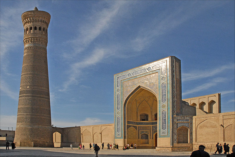
La mosquée Kalon ou "grande mosquée" (à droite) est la "mosquée du vendredi" de Boukhara. C'est l'une des mosquées les plus anciennes mais aussi les plus vastes de l'Asie centrale. Elle pouvait accueillir 10.000 fidèles. La première construction sur ce site date de 795 par les conquérants arabes. Le bâtiment actuel a été achevé en 1514, par la suite il a été embelli puis restauré au cours de l'époque soviétique. Le minaret Kalon (à gauche) a été construit en 1127 par le Karakhanide Arslan Khan. Haut de 48m, il servait à appeler à la prière mais également, au 17ème siècle, à jeter dans le vide les condamnés à mort. Une autre fonction était de servir de phare pour les caravanes arrivant du désert car un feu était allumé à son sommet chaque nuit. De forme conique, il est décoré de motifs géométriques réalisés en briques. Le minaret a été restauré dans les années 1930 puis dans les années 1970 à la suite d'un tremblement de terre. Le minaret est le symbole de Boukhara, "Perle de l'Islam, oasis au coeur du désert Kyzyl Kum et ville sainte, une cité mystérieuse interdite aux infidèles durant plusieurs siècles. |
| Date | |
| Source | Le minaret et la mosquée Kalon (Boukhara, Ouzbékistan) |
| Author | Jean-Pierre Dalbéra from Paris, France |
| Other versions |

_(5658826884).jpg)
| Camera location |
| View this and other nearby images on: OpenStreetMap |
|
|---|
_(5658826884).jpg¶ms=039.779189_N_0064.418163_E_globe:Earth_type:camera_source:Flickr_&language=en)
Licensing
- You are free:
- to share – to copy, distribute and transmit the work
- to remix – to adapt the work
- Under the following conditions:
- attribution – You must give appropriate credit, provide a link to the license, and indicate if changes were made. You may do so in any reasonable manner, but not in any way that suggests the licensor endorses you or your use.
| This image, originally posted to Flickr, was reviewed on 15 February 2013 by the administrator or reviewer File Upload Bot (Magnus Manske), who confirmed that it was available on Flickr under the stated license on that date. |
File history
Click on a date/time to view the file as it appeared at that time.
| Date/Time | Thumbnail | Dimensions | User | Comment | |
|---|---|---|---|---|---|
| current | 17:22, 15 February 2013 |
| 1,793 × 1,200 (1.44 MB) | File Upload Bot (Magnus Manske) | Transferred from Flickr by User:russavia |
File usage
- Ak Mosque
- Baland Mosque
- Bibi-Khanym Mosque
- Bolo Haouz Mosque
- Chor Minor
- Dzhuma Mosque, Tashkent
- Hasanmurod Qushbegi mosque
- Juma Mosque (Khiva)
- Kalan Mosque
- Kalyan Minaret
- Khonakhan Mosque
- Langarota Mosque
- List of World Heritage Sites in Uzbekistan
- List of mosques in Uzbekistan
- Magok-i-Attari Mosque
- Magok-i-Kurpa Mosque
- Po-i-Kalyan
- Uzbekistan
- User:JahlilMA/sandbox
- User:Jlin57/sandbox/Po-i-Kalyan
- Template:Mosques in Uzbekistan
Global file usage
The following other wikis use this file:
- Usage on ar.wikipedia.org
- Usage on az.wikipedia.org
- Usage on ba.wikipedia.org
- Usage on be.wikipedia.org
- Usage on bg.wikipedia.org
- Usage on bn.wikipedia.org
- Usage on da.wikipedia.org
- Usage on de.wikipedia.org
- Usage on de.wikivoyage.org
- Usage on el.wikipedia.org
- Usage on eo.wikivoyage.org
- Usage on fa.wikipedia.org
- Usage on fr.wikipedia.org
- Usage on he.wikivoyage.org
- Usage on kab.wikipedia.org
- Usage on ka.wikipedia.org
- Usage on kk.wikipedia.org
- Usage on ko.wikipedia.org
- Usage on lv.wikipedia.org
- Usage on mad.wikipedia.org
- Usage on mk.wikipedia.org
- Usage on mt.wikipedia.org
- Usage on no.wikipedia.org
- Usage on pl.wikipedia.org
- Usage on pl.wikivoyage.org
- Usage on pnb.wikipedia.org
View more global usage of this file.
_(5658826884).jpg)
_(5658826884).jpg)