
Size of this PNG preview of this SVG file:
512 × 324 pixels. Other resolutions:
320 × 203 pixels |
640 × 405 pixels |
1,024 × 648 pixels |
1,280 × 810 pixels |
2,560 × 1,620 pixels.
Original file (SVG file, nominally 512 × 324 pixels, file size: 867 KB)
| This is a file from the
Wikimedia Commons. Information from its
description page there is shown below. Commons is a freely licensed media file repository. You can help. |
Summary
| Description |
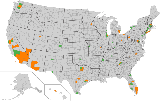
English: Counties with over 1 million inhabitants
Counties with under 1 million inhabitants
A map of the counties of the United States. The 100 most populous counties are highlighted, with those counties having more than one million residents in orange, and those counties having fewer than one million residents in green, as of the April 1, 2020 United States census. |
| Date | |
| Source | Own work |
| Author | Elli |
| Other versions | Map derived from File:Largest counties of the United States by population as of the 2010 United States census.svg |
Licensing
| This map is ineligible for
copyright and therefore in the
public domain, because it consists entirely of information that is common property and contains no original authorship. For more information, see
Commons:Threshold of originality § Maps.
|
File history
Click on a date/time to view the file as it appeared at that time.
| Date/Time | Thumbnail | Dimensions | User | Comment | |
|---|---|---|---|---|---|
| current | 06:40, 24 December 2021 |
| 512 × 324 (867 KB) | Elli | Uploaded own work with UploadWizard |
File usage
The following pages on the English Wikipedia use this file (pages on other projects are not listed):
Global file usage
The following other wikis use this file:
- Usage on cs.wikipedia.org
- Usage on ru.wikipedia.org
- Usage on zh.wikipedia.org