
Size of this preview:
800 × 554 pixels. Other resolutions:
320 × 222 pixels |
640 × 443 pixels |
975 × 675 pixels.
Original file (975 × 675 pixels, file size: 193 KB, MIME type: image/jpeg)
| This is a file from the
Wikimedia Commons. Information from its
description page there is shown below. Commons is a freely licensed media file repository. You can help. |
Summary
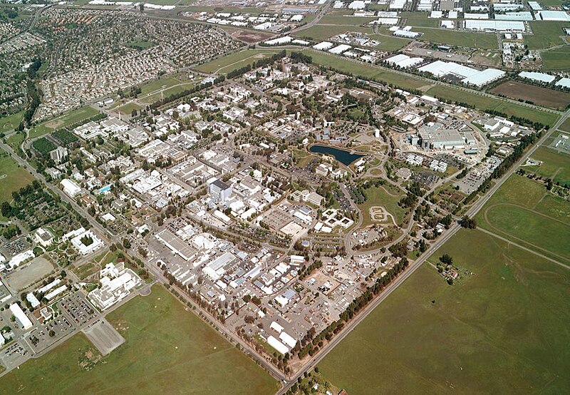
| Description | Lawrence Livermore National Laboratory - aerial view. |
| Source | llnl.gov |
| Author |
| Camera location |
| View this and other nearby images on: OpenStreetMap |
|
|---|
Licensing
This work is in the
public domain in the United States because it is a
work prepared by an officer or employee of the United States Government as part of that person’s official duties under the terms of
Title 17, Chapter 1, Section 105 of the
US Code.
Note: This only applies to original works of the Federal Government and not to the work of any individual
U.S. state,
territory, commonwealth, county, municipality, or any other subdivision. This template also does not apply to postage stamp designs published by the
United States Postal Service
since 1978. (See §
313.6(C)(1) of Compendium of U.S. Copyright Office Practices). It also does not apply to certain US coins; see
The US Mint Terms of Use.
|
 | |
| This file has been identified as being free of known restrictions under copyright law, including all related and neighboring rights. | ||
File history
Click on a date/time to view the file as it appeared at that time.
| Date/Time | Thumbnail | Dimensions | User | Comment | |
|---|---|---|---|---|---|
| current | 18:23, 11 May 2005 |
| 975 × 675 (193 KB) | Floriang | Lawrence Livermore National Laboratory - aerial view. Originally from [http://www.llnl.gov/llnl/06news/NewsMedia/photoarchive.html LLNL.gov]. Converted from LLNL_Aerial_View.png. ''Source'': en, uploaded by en:User:Bkell {{PD-USGov}} [[Category:B |
File usage
The following pages on the English Wikipedia use this file (pages on other projects are not listed):
- History of the University of California, Berkeley
- Lawrence Livermore National Laboratory
- Livermore, California
- Northern California
- Timeline of the San Francisco Bay Area
- University of California
- User:Bkell/Images
- Portal:San Francisco Bay Area/Selected article/39
- Portal:San Francisco Bay Area/Selected article/Archive
- Portal:San Francisco Bay Area/Years/63
- Portal:San Francisco Bay Area/Years/Archive
Global file usage
The following other wikis use this file:
- Usage on ar.wikipedia.org
- Usage on bg.wikipedia.org
- Usage on ca.wikipedia.org
- Usage on ceb.wikipedia.org
- Usage on cs.wikipedia.org
- Usage on da.wikipedia.org
- Usage on de.wikipedia.org
- Usage on de.wikibooks.org
- Usage on de.wikinews.org
- Usage on el.wikipedia.org
- Usage on en.wikibooks.org
- Usage on en.wikinews.org
- Usage on en.wikivoyage.org
- Usage on eo.wikipedia.org
- Usage on es.wikipedia.org
- Usage on et.wikipedia.org
- Usage on fa.wikipedia.org
- Usage on fr.wikipedia.org
- Usage on gd.wikipedia.org
- Usage on he.wikipedia.org
- Usage on hi.wikipedia.org
- Usage on hy.wikipedia.org
- Usage on id.wikipedia.org
- Usage on it.wikipedia.org
- Usage on ja.wikipedia.org
- Usage on ko.wikipedia.org
- Usage on kw.wikipedia.org
- Usage on nn.wikipedia.org
- Usage on no.wikipedia.org
- Usage on pl.wikipedia.org
- Usage on pnb.wikipedia.org
- Usage on pt.wikipedia.org
- Usage on ro.wikipedia.org
- Usage on ru.wikipedia.org
- Usage on ru.wikinews.org
- Usage on simple.wikipedia.org
- Usage on sv.wikipedia.org
View more global usage of this file.