No higher resolution available.
Kocaeli_districts.png (776 × 600 pixels, file size: 128 KB, MIME type: image/png)
| This is a file from the
Wikimedia Commons. Information from its
description page there is shown below. Commons is a freely licensed media file repository. You can help. |
Summary
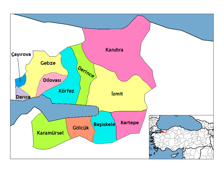
| Description | Map of the districts of Kocaeli province in Turkey. Created by Rarelibra 22:01, 1 December 2006 (UTC) for public domain use, using MapInfo Professional v8.5 and various mapping resources. Edited by One Homo Sapiens Corrected text where İ,Ş,ı,ğ,or ş occurs in name. Source: [statoids-com]. Increased font size and enhanced color differences among adjacent districts. |
| Date | 1 December 2006 (original upload date) |
| Source | No machine-readable source provided. Own work assumed (based on copyright claims). |
| Author | No machine-readable author provided. Rarelibra assumed (based on copyright claims). |
Licensing
| I, the copyright holder of this work, release this work into the
public domain. This applies worldwide. In some countries this may not be legally possible; if so: I grant anyone the right to use this work for any purpose, without any conditions, unless such conditions are required by law. |
File history
Click on a date/time to view the file as it appeared at that time.
| Date/Time | Thumbnail | Dimensions | User | Comment | |
|---|---|---|---|---|---|
| current | 11:58, 11 December 2018 |
| 776 × 600 (128 KB) | Surprizi | Updated/corrected map. |
| 20:25, 28 February 2012 |
 | 469 × 403 (38 KB) | Sadrettin | Reverted to version as of 09:02, 31 August 2009 | |
| 09:54, 26 February 2012 |
 | 776 × 600 (121 KB) | Nanahuatl | Reverted to version as of 13:17, 17 June 2009 | |
| 09:02, 31 August 2009 |
 | 469 × 403 (38 KB) | Krofesyonel | {{Information |Description=Kocaeli'nin doğru haritası, kendi çalışmamdır. |Source=Kendi çalışmam |Date= 31 August 2009, Monday ('' 31 Ağustos 2009, Pazartesi'') |Author= User:Krofesyonel |Permission= |other_versions= }} | |
| 13:17, 17 June 2009 |
 | 776 × 600 (121 KB) | Argymeg | Reverted to version as of 19:23, 7 April 2009 | |
| 19:24, 7 April 2009 |
 | 1,056 × 816 (26 KB) | Derinkaya | Reverted to version as of 01:23, 29 December 2008 | |
| 19:23, 7 April 2009 |
 | 776 × 600 (121 KB) | Derinkaya | {{Information |Description=Map of the districts of Kocaeli province in Turkey. Created by Rarelibra 22:01, 1 December 2006 (UTC) for public domain use, using MapInfo Professional v8.5 and various mapping resources. Edited by [[User:One | |
| 01:23, 29 December 2008 |
 | 1,056 × 816 (26 KB) | One Homo Sapiens | Corrected text where İ,Ş,ı,ğ,or ş occurs in name. Source: [statoids-com]. Increased font size and enhanced color differences among adjacent districts. | |
| 15:58, 12 April 2007 |
 | 776 × 600 (96 KB) | KureCewlik81 | ||
| 14:15, 20 February 2007 |
 | 1,056 × 816 (27 KB) | Rarelibra | Updated/corrected map. |
File usage
The following pages on the English Wikipedia use this file (pages on other projects are not listed):
Global file usage
The following other wikis use this file:
- Usage on azb.wikipedia.org
- Usage on az.wikipedia.org
- Usage on ba.wikipedia.org
- Usage on diq.wikipedia.org
- Usage on en.wiktionary.org
- Usage on eo.wikipedia.org
- Usage on eu.wikipedia.org
- Usage on fa.wikipedia.org
- Usage on fi.wikipedia.org
- Usage on fo.wikipedia.org
- Usage on fr.wikipedia.org
- Usage on hy.wikipedia.org
- Usage on id.wikipedia.org
- Usage on it.wikipedia.org
- Usage on ja.wikipedia.org
- Usage on jv.wikipedia.org
- Usage on ka.wikipedia.org
- Usage on la.wikipedia.org
- Usage on lv.wikipedia.org
- Usage on mr.wikipedia.org
- Usage on ms.wikipedia.org
View more global usage of this file.