
Size of this preview:
664 × 600 pixels. Other resolutions:
266 × 240 pixels |
531 × 480 pixels |
850 × 768 pixels |
1,133 × 1,024 pixels |
2,497 × 2,256 pixels.
Original file (2,497 × 2,256 pixels, file size: 830 KB, MIME type: image/jpeg)
| This is a file from the
Wikimedia Commons. Information from its
description page there is shown below. Commons is a freely licensed media file repository. You can help. |
Summary
| Description |
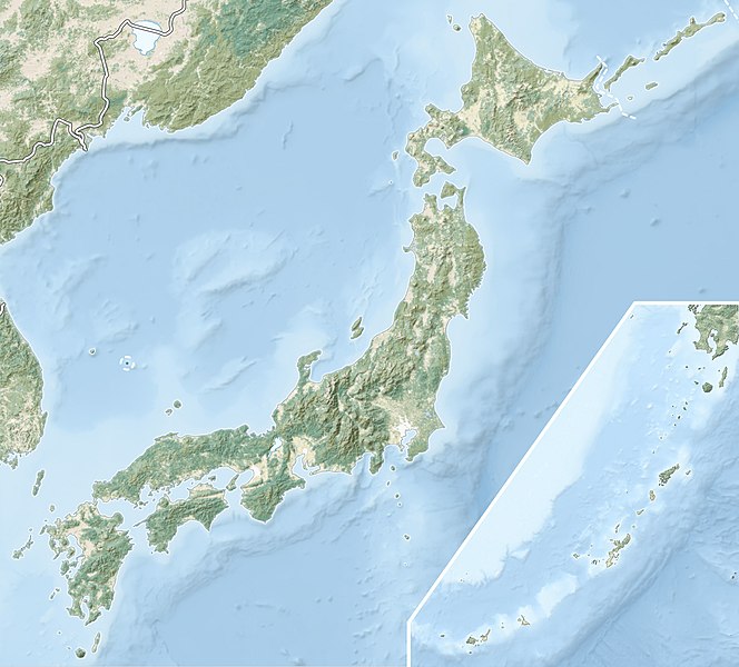
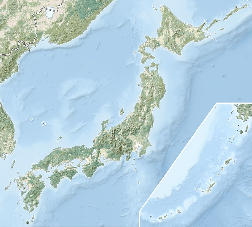
English: Natural Location map of
Japan
Equirectangular projection. Geographic limits to locate objects in the main map with the main islands:
Geographic limits to locate objects in the side map with the Ryukyu Islands:
|
||
| Date | |||
| Source |
|
||
| Author | Alexrk2 | ||
| Permission ( Reusing this file) |
This file is licensed under the
Creative Commons
Attribution-Share Alike 3.0 Unported license.
|
||
| Other versions |
|


File history
Click on a date/time to view the file as it appeared at that time.
| Date/Time | Thumbnail | Dimensions | User | Comment | |
|---|---|---|---|---|---|
| current | 21:41, 9 March 2022 |
| 2,497 × 2,256 (830 KB) | Sting | Natural Earth land cover data for Ryukyu Islands |
| 09:44, 22 June 2018 |
 | 2,497 × 2,256 (794 KB) | Mardetanha | Reverted to version as of 19:56, 22 March 2011 (UTC) | |
| 19:56, 22 March 2011 |
 | 2,497 × 2,256 (794 KB) | Alexrk2 | RGB | |
| 19:07, 22 March 2011 |
 | 2,497 × 2,256 (745 KB) | Chumwa | RGB mode | |
| 21:08, 21 March 2011 |
 | 2,497 × 2,256 (1.54 MB) | Alexrk2 | == {{int:filedesc}} == {{Information |Description= {{en|Natural Location map of Japan Equirectangular projection. Geographic limits to locate objects in the main map with the main islands: * N: 45°51'37" N (45.86°N) * S: 30°01'13" N (30. |
File usage
More than 100 pages use this file. The following list shows the first 100 pages that use this file only. A full list is available.
- 2004 Chūetsu earthquake
- Abukuma River
- Aizuwakamatsu Castle
- Akaishi Mountains
- Akan Mashu National Park
- Alpine skiing at the 1998 Winter Olympics
- Battle of Anegawa
- Battle of Dan-no-ura
- Battle of Fujigawa
- Battle of Kojima
- Battle of Kurikara Pass
- Battle of Mikatagahara
- Battle of Nagashino
- Battle of Okehazama
- Battle of Sekigahara
- Battle of Shinohara
- Battle of Shizugatake
- Battle of Sunomata-gawa
- Battle of Tedorigawa
- Battle of Uchidehama
- Battle of Uedahara
- Battle of Uji (1184)
- Battle of Uji (1221)
- Battle of Yamazaki
- Battle of Yashima
- Battles of Kawanakajima
- Bungo Channel
- Bōsō Peninsula
- Chichibu Tama Kai National Park
- Chikuma, Nagano
- Fuji-Hakone-Izu National Park
- Fushimi Castle
- Great Hanshin earthquake
- Hikone Castle
- Hirado Castle
- Hiroshima Peace Memorial
- Ikedaya incident
- Inō Tadataka
- Itsukushima Shrine
- Iturup
- Izu Peninsula
- Japan Coast Guard Academy
- Japanese Alps
- Kadena Air Base
- Kamaishi, Iwate
- Kerama Islands
- Kiyomizu-dera
- Kokura Castle
- Kunashir
- Kunigami, Okinawa
- Kurobe Dam
- Kyoto
- Lake Biwa
- Lake Mashū
- Lake Towada
- List of national parks of Japan
- Maruoka Castle
- Matsue Castle
- Matsumae Castle
- Miho Museum
- Mii-dera
- Mine, Saga
- Miyako-jima
- Mount Akagi
- Mount Asama
- Mount Aso
- Mount Fuji
- Mount Haruna
- Mount Ibuki
- Mount Kōya
- Mount Myōgi
- Mount Naeba
- Mount Osore
- Mount Tsukuba
- Mount Unzen
- Nagashino Castle
- Nagoya Castle
- Nii Ōshima
- Nipesotsu-Maruyama Volcanic Group
- Noda Castle
- Odawara Castle
- Ogachi, Akita
- Oirase River
- Okazaki Castle
- Osaka Bay
- Sakurajima
- Sendai Station
- Seto Inland Sea
- Siege of Marune
- Siege of Miki
- Siege of Osaka
- Siege of Takamatsu
- Siege of Terabe
- Siege of Ueda
- Sieges of Nagashima
- Tarama, Okinawa
- Toi invasion
- Tsugaru Strait
- Yakushima
- Yama-dera
View more links to this file.
Global file usage
The following other wikis use this file:
- Usage on ace.wikipedia.org
- Usage on als.wikipedia.org
- Usage on ar.wikipedia.org
- Usage on arz.wikipedia.org
- Usage on ast.wikipedia.org
- Usage on as.wikipedia.org
- Usage on azb.wikipedia.org
- Usage on az.wikipedia.org
- Hokkaydo
- Kyuşu
- Fuci
- Honşu
- İtsukuşima
- Asama dağı
- Şablon:Yer xəritəsi Yaponiya
- Tohoku zəlzələsi və sunamisi (2011)
- Fukuşima-1 AES
- Böyük Hanşin zəlzələsi
- Böyük Kanto zəlzələsi
- Hoey zəlzələsi
- Mino-Ovari zəlzələsi (1891)
- Yapon çökəkliyi
- Ryukyu adaları
- Osumi boğazı
- Sanqar boğazı
- Koreya boğazı
- Tsuşima boğazı
- Harim dənizi
- Yatsuşiro dənizi
- Hiuqa dənizi
- Daxili Yapon dənizi
- Atsumi yarımadası
- Naqasaki yarımadası
- İzu yarımadası
- Simabara yarımadası
- Şiretoko yarımadası
- Nosuke yarımadası
View more global usage of this file.