
Original file (10,630 × 1,275 pixels, file size: 5.93 MB, MIME type: image/jpeg)
| This is a file from the
Wikimedia Commons. Information from its
description page there is shown below. Commons is a freely licensed media file repository. You can help. |
Summary
| Description |
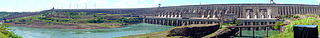
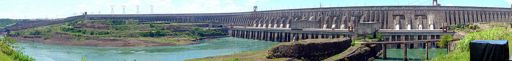
Čeština: Panorama Hydroelektrárny Itaipu, pohled na přehradu z brazilské strany.
Français : Panorama du Barrage Hydroélectrique de Itaipu. Photo prise du côté brésilien.
English: Panorama of Itaipu Hydroelectric Dam from brazilian side.
Esperanto: Panoramo de la
Hidroelektra Centralo de Itaipu vidata de la brazila flanko.
Deutsch: Panorama von Itaipu Staudamms von brasilianischer Seite. |
| Date | |
| Source | Own work |
| Author | Martin St-Amant ( S23678) |
| Camera location |
| View this and other nearby images on: OpenStreetMap |
|
|---|
Licensing

|
Français :
Cette photographie a été prise et modifiée par
Martin St-Amant. Je distribue cette photographie sous la licence
Creative Commons
Paternité version 3.0 Unported English:
This picture was taken and modified by
Martin St-Amant.
I distribute this image under the
Creative Commons
Attribution 3.0 Unported License |
- You are free:
- to share – to copy, distribute and transmit the work
- to remix – to adapt the work
- Under the following conditions:
- attribution – You must give appropriate credit, provide a link to the license, and indicate if changes were made. You may do so in any reasonable manner, but not in any way that suggests the licensor endorses you or your use.
- share alike – If you remix, transform, or build upon the material, you must distribute your contributions under the same or compatible license as the original.
File history
Click on a date/time to view the file as it appeared at that time.
| Date/Time | Thumbnail | Dimensions | User | Comment | |
|---|---|---|---|---|---|
| current | 18:08, 26 April 2008 |
| 10,630 × 1,275 (5.93 MB) | S23678 | {{Information |Description= {{fr|Panorama du barrage hydroélectrique de Itaipu. Photo prise du côté brésilien}} {{en|Panorama of Itaipu hydroelectric dam from brasilian side }} |Source= {{fr|Travail personnel}} {{en|Own work}} |Date=2007-12-26 |Author |
File usage
Global file usage
The following other wikis use this file:
- Usage on ar.wikipedia.org
- Usage on ast.wikipedia.org
- Usage on bg.wikipedia.org
- Usage on ca.wikipedia.org
- Usage on cs.wikipedia.org
- Usage on en.wikivoyage.org
- Usage on eo.wikipedia.org
- Usage on es.wikipedia.org
- Usage on fa.wikipedia.org
- Usage on fr.wikipedia.org
- Usage on he.wikipedia.org
- Usage on hr.wikipedia.org
- Usage on hu.wikipedia.org
- Usage on hy.wikipedia.org
- Usage on ka.wikipedia.org
- Usage on lt.wikipedia.org
- Usage on mk.wikipedia.org
- Usage on ml.wikipedia.org
- Usage on my.wikipedia.org
- Usage on ne.wikipedia.org
- Usage on no.wikipedia.org
- Usage on or.wikipedia.org
- Usage on pt.wikipedia.org
- Usage on sh.wikipedia.org
- Usage on sl.wikipedia.org
- Usage on th.wikipedia.org
- Usage on vi.wikipedia.org
- Usage on www.wikidata.org