
Size of this preview:
800 × 576 pixels. Other resolutions:
320 × 230 pixels |
640 × 461 pixels |
1,024 × 737 pixels |
1,280 × 922 pixels |
1,600 × 1,152 pixels.
Original file (1,600 × 1,152 pixels, file size: 304 KB, MIME type: image/jpeg)
| This is a file from the
Wikimedia Commons. Information from its
description page there is shown below. Commons is a freely licensed media file repository. You can help. |
 | This image was previously a featured picture, but community consensus determined that it no longer meets our featured-picture criteria. If you have a high-quality image that you believe meets the criteria, be sure to upload it, using the proper free-license tag, then add it to a relevant article and nominate it. |
|
| This image was selected as picture of the day on the English Wikipedia for December 1, 2005. |
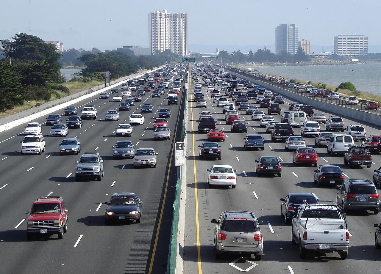
| Description | Looking south above en:Interstate 80, the Eastshore Freeway, near en:Berkeley, California on a Saturday afternoon. en:Emeryville, California is at the towers, en:Aquatic Park (Berkeley) is visible to the left. To the right is the east shore of the en:San Francisco Bay. Picture taken by Minesweeper on May 14, 2005. |
| Source | Minesweeper |
| Author | User Minesweeper on en.wikipedia |
| Permission ( Reusing this file) |
Released under the GNU Free Documentation License. |
| Other versions |
Originally from en.wikipedia; description page is (was) here * 10:17, 15 May 2005 [[:en:User:Minesweeper|Minesweeper]] 1600×1152 (311,297 bytes) <span class="comment">(Looking south above Interstate 80, the Eastshore Freeway, near Berkeley, California on a Saturday afternoon. Picture taken by me on May 14, 2005. {{GFDL}})</span> |
| Camera location | | View this and other nearby images on: OpenStreetMap |
|
|---|

|
Permission is granted to copy, distribute and/or modify this document under the terms of the GNU Free Documentation License, Version 1.2 or any later version published by the Free Software Foundation; with no Invariant Sections, no Front-Cover Texts, and no Back-Cover Texts. A copy of the license is included in the section entitled GNU Free Documentation License. |
| This file is licensed under the Creative Commons Attribution-Share Alike 3.0 Unported license. | ||
| ||
| This licensing tag was added to this file as part of the GFDL licensing update. |
(Uploaded using CommonsHelper or PushForCommons)
File history
Click on a date/time to view the file as it appeared at that time.
| Date/Time | Thumbnail | Dimensions | User | Comment | |
|---|---|---|---|---|---|
| current | 04:28, 23 October 2006 |
| 1,600 × 1,152 (304 KB) | Zzyzx11 | {{Information| |Description= Looking south above en:Interstate 80, the Eastshore Freeway, near en:Berkeley, California on a Saturday afternoon. Picture taken by Minesweeper on May 14, 2005. |Source= |Date= |Author=User |
File usage
The following pages on the English Wikipedia use this file (pages on other projects are not listed):
- Energy law
- Hayward Fault Zone
- Interstate 80
- Interstate 80 in California
- Mode of transport
- Motor vehicle
- Northern California
- Pacific Park Plaza
- Richmond, California
- Three-phase traffic theory
- Transport economics
- Transportation in California
- Transportation in the San Francisco Bay Area
- User:Cyde/Featured pictures
- User:Cymruman
- User:JacobS/userboxes
- User:Kitschqueen
- User:Mercurywoodrose/SFBA galleries
- User:New4321
- User:Roadnote
- User:Roadnote/Pages
- User:Roadnote/Top
- User:Roadnote/Unuseful Stuff
- User:Roadnote/Useful Stuff
- User:Roadnote/Userboxes
- User:Roadnote/Userpage V1
- User:Taifarious1/Userboxes
- User:The4325
- User:The4532
- User:Tom Danson
- User talk:Elf/Archive 4
- User talk:Minesweeper
- User talk:Roadnote
- Wikipedia:Featured picture candidates/Autoroute Ville-Marie
- Wikipedia:Featured picture candidates/I-80 Eastshore Fwy
- Wikipedia:Featured picture candidates/March-2006
- Wikipedia:Featured picture candidates/September-2005
- Wikipedia:Featured picture candidates/delist/2008
- Wikipedia:Featured picture candidates/delist/Image:I-80 Eastshore Fwy.jpg
- Wikipedia:POTD/December 1, 2005
- Wikipedia:Picture of the day/December 1, 2005
- Wikipedia:Picture of the day/December 2005
- Wikipedia:WikiProject Transport/images/3
- Wikipedia:WikiProject U.S. Roads/California
- Wikipedia:WikiProject U.S. Roads/California/Recognized content
- Wikipedia:WikiProject U.S. Roads/Interstate Highways
- Wikipedia:WikiProject U.S. Roads/Interstate Highways/Recognized content
- Wikipedia:WikiProject U.S. Roads/Main page content
- Wikipedia:WikiProject U.S. Roads/Recognized content
- Wikipedia:Wikipedia Signpost/2005-09-26/Features and admins
- Wikipedia:Wikipedia Signpost/Single/2005-09-26
- Wikipedia talk:WikiProject Automobiles/Archive 38
- Template:User WikiProject U.S. Cities
- Portal:California roads
- Portal:California roads/Selected picture
- Portal:California roads/Selected picture/1
- Portal:Energy/Selected picture
- Portal:Energy/Selected picture/18
- Portal:Geography/Featured picture/2007, week 31
- Portal:Geography/Featured picture archive/2007
- Portal:San Francisco Bay Area/Selected article/77
- Portal:San Francisco Bay Area/Selected article/Archive
- Portal:San Francisco Bay Area/Selected picture/11
- Portal:San Francisco Bay Area/Selected picture/Archive
- Portal:U.S. roads/Selected picture
- Portal:U.S. roads/Selected picture/February 2006
- Portal talk:California
Global file usage
The following other wikis use this file:
- Usage on af.wikipedia.org
- Usage on als.wikipedia.org
- Usage on ar.wikipedia.org
- Usage on ar.wiktionary.org
- Usage on ast.wikipedia.org
- Usage on az.wikipedia.org
- Usage on be.wikipedia.org
- Usage on bg.wikipedia.org
- Usage on bh.wikipedia.org
- Usage on bn.wikipedia.org
- Usage on br.wikipedia.org
- Usage on bs.wikipedia.org
- Usage on ca.wikipedia.org
- Usage on cdo.wikipedia.org
- Usage on cv.wikipedia.org
- Usage on cy.wikipedia.org
- Usage on da.wikipedia.org
- Usage on de.wikipedia.org
- Usage on de.wikibooks.org
- Usage on el.wikipedia.org
- Usage on en.wikibooks.org
View more global usage of this file.