
Size of this preview:
785 × 600 pixels. Other resolutions:
314 × 240 pixels |
628 × 480 pixels |
789 × 603 pixels.
Original file (789 × 603 pixels, file size: 127 KB, MIME type: image/png)
| This is a file from the
Wikimedia Commons. Information from its
description page there is shown below. Commons is a freely licensed media file repository. You can help. |

|
This historical map image could be re-created using
vector graphics as an
SVG file. This has several advantages; see
Commons:Media for cleanup for more information. If an SVG form of this image is available, please upload it and afterwards replace this template with
{{
vector version available|new image name}}
.
It is recommended to name the SVG file “Haupthandelsroute Hanse.svg”—then the template Vector version available (or Vva) does not need the new image name parameter. |
Summary
| Description |
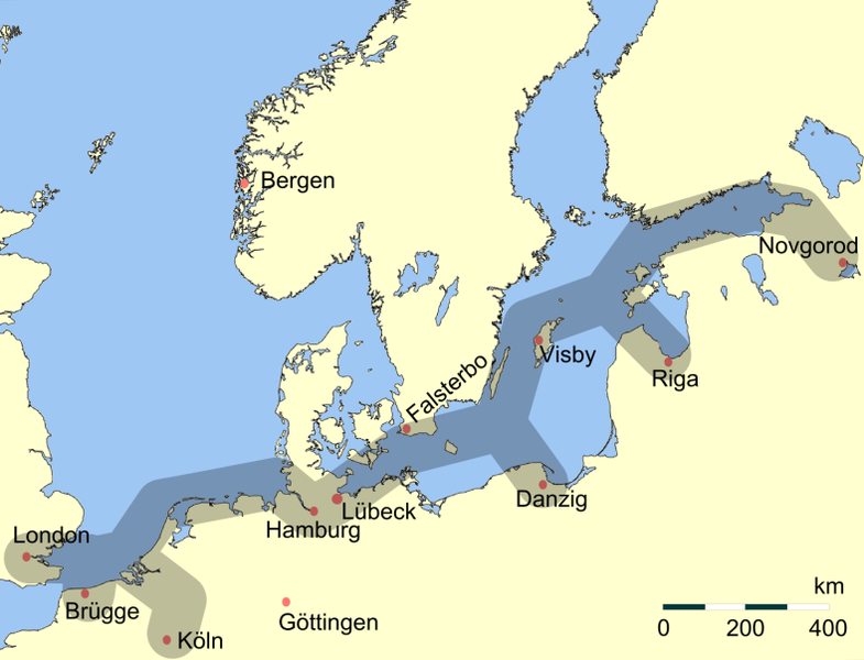
Deutsch: Vereinfachte Darstellung der Haupthandelsroute der
Hanse im Nordeuropäischen Raum. Eigene verbesserte Darstellung mit GMT.
English: Main trading routes of the Hanseatic League in northern Europe.
Svenska: Förenklad översikt över Hansans viktigaste handelsvägar i norra Europa. |
| Date | |
| Source | Own work |
| Author | Flo Beck |
| Other versions | العربيَّة |
Licensing
| I, the copyright holder of this work, release this work into the
public domain. This applies worldwide. In some countries this may not be legally possible; if so: I grant anyone the right to use this work for any purpose, without any conditions, unless such conditions are required by law. |
| This work has been released into the
public domain by its author,
German Wikipedia at
German Wikipedia. This applies worldwide. In some countries this may not be legally possible; if so: German Wikipedia grants anyone the right to use this work for any purpose, without any conditions, unless such conditions are required by law. |
File history
Click on a date/time to view the file as it appeared at that time.
| Date/Time | Thumbnail | Dimensions | User | Comment | |
|---|---|---|---|---|---|
| current | 13:26, 6 June 2022 |
| 789 × 603 (127 KB) | 野良人 | opt |
| 12:30, 7 May 2012 |
 | 789 × 603 (130 KB) | Ras67 | cropped, opt. | |
| 02:34, 25 March 2006 |
 | 795 × 609 (175 KB) | Flo Beck | Vereinfachte Darstellung der Haupthandelsroute der Hanse im Nordeuropäischen Raum, eigene verbesserte Darstellung mit GMT, erstellt von Flo Beck {{PD-user-de|German Wikipedia|Flo Beck}} |
File usage
More than 100 pages use this file. The following list shows the first 100 pages that use this file only. A full list is available.
- Antwerp
- Baltic Sea
- Bergen
- Berlin
- Berwick-upon-Tweed
- Bochum
- Boston, Lincolnshire
- Brandenburg an der Havel
- Braunschweig
- Breckerfeld
- Bremen
- Bruges
- Bryggen
- Cologne
- Damme
- Danish-Hanseatic War (1361-1370)
- Deventer
- Dominium maris baltici
- Dortmund
- Duisburg
- Dutch–Hanseatic War
- Economic history of Europe (1000 AD–present)
- Economic history of Germany
- Elbląg
- Erfurt
- Factory (trading post)
- Frankfurt (Oder)
- Gdańsk
- Goslar
- Great Yarmouth
- Greifswald
- Groningen
- Halle (Saale)
- Haltern am See
- Hamburg
- Hamm, North Rhine-Westphalia
- Hanseatic League
- Harderwijk
- Hasselt, Overijssel
- Hattem
- History of Cologne
- History of Germans in Russia, Ukraine, and the Soviet Union
- History of Germany
- History of Hamburg
- History of Latvia
- Ipswich
- Kampen, Overijssel
- Kaunas
- Kiel
- King's Lynn
- Kingston upon Hull
- Kontor
- Kraków
- Königsberg
- Leith
- Lübeck
- Lüneburg
- Magdeburg
- Mühlhausen
- Münster
- Newcastle upon Tyne
- Nijmegen
- Nordhausen, Thuringia
- Oldenzaal
- Osnabrück
- Pasewalk
- Polotsk
- Port of Ipswich
- Pskov
- Pskov Republic
- Pärnu
- Quedlinburg
- Recklinghausen
- Renaissance of the 12th century
- Riga
- Roermond
- Rostock
- Soest, Germany
- Stade
- Stargard
- Steelyard
- Stockholm
- Stralsund
- Tallinn
- Tartu
- Tiel
- Toruń
- Trade route
- Unna
- Veliky Novgorod
- Viljandi
- Visby
- Werl
- Wismar
- Wrocław
- York
- Zutphen
- Zwolle
- User:Editorofthewiki/Drafts/Draft 1
- User:Jnhernandez-torres/sandbox
View more links to this file.
Global file usage
The following other wikis use this file:
- Usage on af.wikipedia.org
- Usage on an.wikipedia.org
- Usage on ar.wikipedia.org
- Usage on arz.wikipedia.org
- Usage on ast.wikipedia.org
- Usage on ban.wikipedia.org
- Usage on ba.wikipedia.org
- Usage on be.wikipedia.org
- Usage on bg.wikipedia.org
- Usage on br.wikipedia.org
- Usage on bs.wikipedia.org
- Usage on ca.wikipedia.org
- Usage on csb.wikipedia.org
- Usage on cs.wikipedia.org
- Usage on cu.wikipedia.org
- Usage on cy.wikipedia.org
- Usage on da.wikipedia.org
- Usage on de.wikipedia.org
View more global usage of this file.