No higher resolution available.
Harpers_Ferry_WV_aerial.jpg (413 × 320 pixels, file size: 57 KB, MIME type: image/jpeg)
| This is a file from the
Wikimedia Commons. Information from its
description page there is shown below. Commons is a freely licensed media file repository. You can help. |
Summary
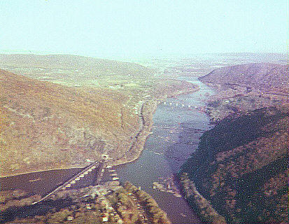
| Description |
English: The
confluence of the
Potomac and
Shenandoah Rivers, at
Harpers Ferry
35px. Aerial view looking east towards
Maryland, with the
CSX RR bridge crossing the river. |
| Date | |
| Source | Own work (Original text: User:JGHowes) |
| Author |
User:JGHowes, photographer
|
| Permission ( Reusing this file) |
© by James G. Howes, October, 1974. Copyright holder must be properly attributed. |
Licensing

|
The copyright holder of this file, James G. Howes, allows anyone to use it for any purpose, provided that the copyright holder is properly attributed. Redistribution, derivative work, commercial use, and all other use is permitted. |
Attribution:
James G. Howes
|
Original upload log
Transferred from en.wikipedia to Commons by Fredlyfish4 using CommonsHelper.
The original description page was
here. All following user names refer to en.wikipedia.
- 2008-01-23 03:06 JGHowes 413×320× (58313 bytes) {{Information |Description=The [[confluence]] of the [[Potomac]] and [[Shenandoah River]]s, at [[Harpers Ferry, West Virginia]] [[Image:Flag of West Virginia.svg|35px]]. Aerial view looking east towards [[Maryland]], with the [[CSX Transportation|CSX RR]]
File history
Click on a date/time to view the file as it appeared at that time.
| Date/Time | Thumbnail | Dimensions | User | Comment | |
|---|---|---|---|---|---|
| current | 01:08, 9 October 2012 |
| 413 × 320 (57 KB) | File Upload Bot (Magnus Manske) | Transfered from en.wikipedia by User:Fredlyfish4 using CommonsHelper |
File usage
The following pages on the English Wikipedia use this file (pages on other projects are not listed):
Global file usage
The following other wikis use this file:
- Usage on el.wikipedia.org
- Usage on he.wikipedia.org
- Usage on ja.wikipedia.org
- Usage on sh.wikipedia.org
- Usage on sr.wikipedia.org
- Usage on tr.wikipedia.org
- Usage on zh.wikipedia.org