
Size of this preview:
714 × 599 pixels. Other resolutions:
286 × 240 pixels |
572 × 480 pixels |
915 × 768 pixels |
1,220 × 1,024 pixels |
2,439 × 2,048 pixels |
11,570 × 9,714 pixels.
Original file (11,570 × 9,714 pixels, file size: 27.73 MB, MIME type: image/jpeg)
| This is a file from the
Wikimedia Commons. Information from its
description page there is shown below. Commons is a freely licensed media file repository. You can help. |
| Warning | The original file is very high-resolution. It might not load properly or could cause your browser to freeze when opened at full size. |
|---|
Summary
| Description |
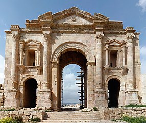
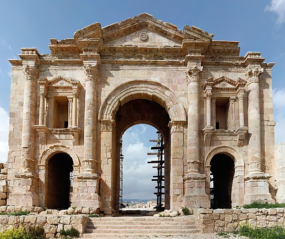
Deutsch: Der Triumphbogen (Hadriansbogen) im Süden der römischen Stadt
Gerasa (heute: Jerasa) in Jordanien. Der dreiteilige Triumphbogen wurde laut Inschrift zum Gedenken an den Besuch Kaiser Hadrians im Winter 129/130 n. Chr. errichtet. Das Bauwerk ist 25 m breit und ca. 21,5 m hoch. Der Hauptdurchgang ist 6 m breit und knapp 11 m hoch, während die beiden seitlichen Eingänge 2,5 m breit und über 5 m hoch sind. Der Oberbau über dem Scheitelpunkt des Mittelbogens konnte seit den 1980er Jahren von der jordanischen Antikenverwaltung praktisch vollständig aus den heruntergefallenen antiken Trümmersteinen rekonstruiert werden (Quelle: Franz Rainer Scheck: Jordanien. Völker und Kulturen zwischen Jordan und Rotem Meer, DuMont Kunstreiseführer, Köln 1997,
ISBN
3-7701-3979-8, S.163f.).
English: The Triumphal Arch (Hadrian's Arch) in the south of the Roman city of
Gerasa (now Jerash) in Jordan. The tripartite triumphal arch was erected in commemoration of emperor Hadrian's visit to the city in 129/130 AD. The building is 25 m wide and ca. 21.5 m high. The main entrance is 6 m wide and 11 m high, while the side entrances are 2.5 m wide and 5 m high. The upper part above the peak of the main arch has been practically completely restored by the Department of Antiquities of Jordan by reusing the ancient ashlar around the arch (Source: Franz Rainer Scheck: Jordanien. Völker und Kulturen zwischen Jordan und Rotem Meer, DuMont Kunstreiseführer, Köln 1997,
ISBN
3-7701-3979-8, p.163f.). |
| Date | |
| Source | Own work |
| Author | Askii |
| Other versions |
 |
| Camera location |
| View this and other nearby images on: OpenStreetMap |
|
|---|
Licensing
I, the copyright holder of this work, hereby publish it under the following license:
This file is licensed under the
Creative Commons
Attribution 3.0 Unported license.
- You are free:
- to share – to copy, distribute and transmit the work
- to remix – to adapt the work
- Under the following conditions:
- attribution – You must give appropriate credit, provide a link to the license, and indicate if changes were made. You may do so in any reasonable manner, but not in any way that suggests the licensor endorses you or your use.
File history
Click on a date/time to view the file as it appeared at that time.
| Date/Time | Thumbnail | Dimensions | User | Comment | |
|---|---|---|---|---|---|
| current | 18:31, 17 September 2020 |
| 11,570 × 9,714 (27.73 MB) | 0m9Ep | Crop |
| 13:14, 11 April 2009 |
 | 12,391 × 13,562 (38.32 MB) | Askii | Original resolution image | |
| 19:57, 23 March 2008 |
 | 3,098 × 3,391 (4.35 MB) | Askii | {{Information |Description=Panoramic view of Hadrian's Arc, Jerash, Jordam |Source=self-made |Date=13.03.2008 |Author= Askii |Permission=See below |other_versions=n/a }} |
File usage
The following pages on the English Wikipedia use this file (pages on other projects are not listed):
Global file usage
The following other wikis use this file:
- Usage on ca.wikipedia.org
- Usage on fa.wikipedia.org
- Usage on fr.wikipedia.org
- Usage on he.wikipedia.org
- Usage on hu.wikipedia.org
- Usage on it.wikipedia.org
- Usage on ja.wikipedia.org
- Usage on lt.wikipedia.org
- Usage on sl.wikipedia.org