
Size of this preview:
724 × 600 pixels. Other resolutions:
290 × 240 pixels |
579 × 480 pixels |
927 × 768 pixels |
1,236 × 1,024 pixels |
1,500 × 1,243 pixels.
Original file (1,500 × 1,243 pixels, file size: 695 KB, MIME type: image/png)
| This is a file from the
Wikimedia Commons. Information from its
description page there is shown below. Commons is a freely licensed media file repository. You can help. |

|
This map image could be re-created using
vector graphics as an
SVG file. This has several advantages; see
Commons:Media for cleanup for more information. If an SVG form of this image is available, please upload it and afterwards replace this template with
{{
vector version available|new image name}}
.
It is recommended to name the SVG file “Great Lakes 1.svg”—then the template Vector version available (or Vva) does not need the new image name parameter. |
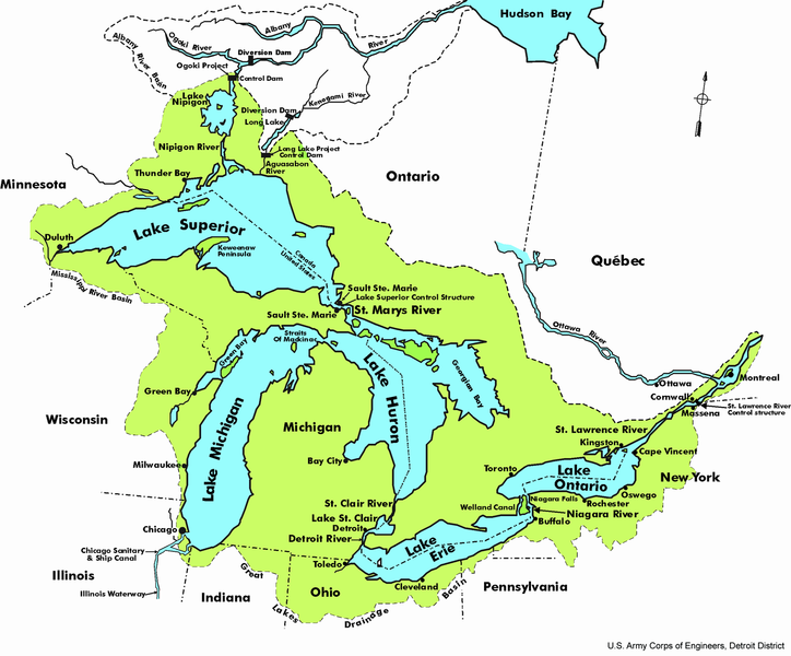
© U.S. Army Corps of Engineers, Detroit District.
This image or file is a work of a
U.S. Army Corps of Engineers soldier or employee, taken or made as part of that person's official duties. As a
work of the
U.S. federal government, the image is in the
public domain.
|
File history
Click on a date/time to view the file as it appeared at that time.
| Date/Time | Thumbnail | Dimensions | User | Comment | |
|---|---|---|---|---|---|
| current | 15:20, 26 March 2005 |
| 1,500 × 1,243 (695 KB) | Nord68 | © U.S. Army Corps of Engineers, Detroit District. {{PD-USGov-Military}} |
File usage
The following pages on the English Wikipedia use this file (pages on other projects are not listed):
Global file usage
The following other wikis use this file:
- Usage on af.wikipedia.org
- Usage on als.wikipedia.org
- Usage on an.wikipedia.org
- Usage on ar.wikipedia.org
- Usage on arz.wikipedia.org
- Usage on ba.wikipedia.org
- Usage on be.wikipedia.org
- Usage on br.wikipedia.org
- Usage on ce.wikipedia.org
- Usage on cs.wikipedia.org
- Usage on cv.wikipedia.org
- Usage on de.wikipedia.org
- Usage on de.wikivoyage.org
- Usage on en.wikibooks.org
- Usage on eo.wikipedia.org
- Usage on es.wikipedia.org
- Usage on fo.wikipedia.org
- Usage on fr.wikipedia.org
- Wikipédia:Le saviez-vous ?/Archives/2007
- Discussion:Grands Lacs (Amérique du Nord)
- Lac Nipigon
- Portail:Lacs et cours d'eau/Le saviez-vous ?
- Portail:Lacs et cours d'eau/Le saviez-vous ?/54
- Catégorie:Système hydrologique des Grands Lacs
- Discussion:Île Manitoulin/LSV 14509
- Discussion:Mer Caspienne/LSV 18820
- Usage on fy.wikipedia.org
- Usage on gl.wikipedia.org
- Usage on he.wikipedia.org
- Usage on hif.wikipedia.org
- Usage on hi.wikipedia.org
- Usage on hsb.wikipedia.org
- Usage on hu.wikipedia.org
- Usage on hy.wikipedia.org
- Usage on id.wikipedia.org
- Usage on incubator.wikimedia.org
- Usage on it.wikipedia.org
- Usage on kbd.wikipedia.org
- Usage on li.wikipedia.org
- Usage on min.wikipedia.org
- Usage on nl.wikipedia.org
View more global usage of this file.