
Size of this preview:
800 × 447 pixels. Other resolutions:
320 × 179 pixels |
640 × 357 pixels |
1,024 × 572 pixels |
1,280 × 714 pixels |
2,560 × 1,429 pixels |
3,832 × 2,139 pixels.
Original file (3,832 × 2,139 pixels, file size: 3.35 MB, MIME type: image/jpeg)
| This is a file from the
Wikimedia Commons. Information from its
description page there is shown below. Commons is a freely licensed media file repository. You can help. |
Summary
| Description |
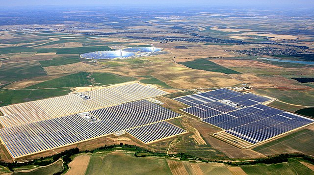
English: Aerial view of the unit I, III, and IV, of Abengoa Solar's
Solnova Solar Power Station. The two towers and reflective mirrors in the background are the
PS10 and
PS20 solar power plants, also owned by Abengoa Solar. This region is also sometimes known as the
Solar Platform. |
| Date | |
| Source | Abengoa Solar |
| Author | Abengoa Solar |
| Object location |
| View this and other nearby images on: OpenStreetMap |
|
|---|
Licensing
This file is licensed under the
Creative Commons
Attribution 1.0 Generic license.
- You are free:
- to share – to copy, distribute and transmit the work
- to remix – to adapt the work
- Under the following conditions:
- attribution – You must give appropriate credit, provide a link to the license, and indicate if changes were made. You may do so in any reasonable manner, but not in any way that suggests the licensor endorses you or your use.
| Annotations | This image is annotated: View the annotations at Commons |
File history
Click on a date/time to view the file as it appeared at that time.
| Date/Time | Thumbnail | Dimensions | User | Comment | |
|---|---|---|---|---|---|
| current | 17:36, 21 May 2014 |
| 3,832 × 2,139 (3.35 MB) | Harryzilber | Fr: image découpée pour améliorer détail <br> Es: imagen recortada para mejorar los detalles <br> En: image cropped to enhance detail |
| 10:27, 30 January 2012 |
 | 4,356 × 2,597 (3.7 MB) | AndreasPraefcke | Reverted to version as of 11:35, 13 November 2010 | |
| 04:41, 15 October 2011 |
 | 4,356 × 2,597 (1.83 MB) | Jakuzem | Reduced file size by selecting higher compression. | |
| 11:35, 13 November 2010 |
 | 4,356 × 2,597 (3.7 MB) | Rehman | correcting image tilt | |
| 10:45, 12 November 2010 |
 | 4,458 × 2,748 (10.84 MB) | Rehman | {{Information |Description={{en|1=Aerial view of the unit I, II, and IV, of Abengoa Solar's {{W|Solnova Solar Power Station}}. The two towers and reflective mirrors in the background are the PS10 and [[:Category:PS20 S |
File usage
The following pages on the English Wikipedia use this file (pages on other projects are not listed):
Global file usage
The following other wikis use this file:
- Usage on ar.wikipedia.org
- Usage on bn.wikipedia.org
- Usage on ckb.wikipedia.org
- Usage on cs.wikipedia.org
- Usage on es.wikipedia.org
- Usage on fa.wikipedia.org
- Usage on fr.wikipedia.org
- Usage on gu.wikipedia.org
- Usage on hr.wikipedia.org
- Usage on hy.wikipedia.org
- Usage on io.wikipedia.org
- Usage on it.wikipedia.org
- Usage on ja.wikipedia.org
- Usage on ko.wikipedia.org
- Usage on la.wikipedia.org
- Usage on pt.wikipedia.org
- Usage on ro.wikipedia.org
- Usage on ru.wikipedia.org
- Usage on sd.wikipedia.org
- Usage on so.wikipedia.org
- Usage on sq.wikipedia.org
- Usage on sr.wikipedia.org
- Usage on sv.wikipedia.org
- Usage on th.wikipedia.org
- Usage on ur.wikipedia.org
- Usage on zh.wikipedia.org