
Size of this PNG preview of this SVG file:
680 × 520 pixels. Other resolutions:
314 × 240 pixels |
628 × 480 pixels |
1,004 × 768 pixels |
1,280 × 979 pixels |
2,560 × 1,958 pixels.
Original file (SVG file, nominally 680 × 520 pixels, file size: 230 KB)
| This is a file from the
Wikimedia Commons. Information from its
description page there is shown below. Commons is a freely licensed media file repository. You can help. |
Summary
| Description |
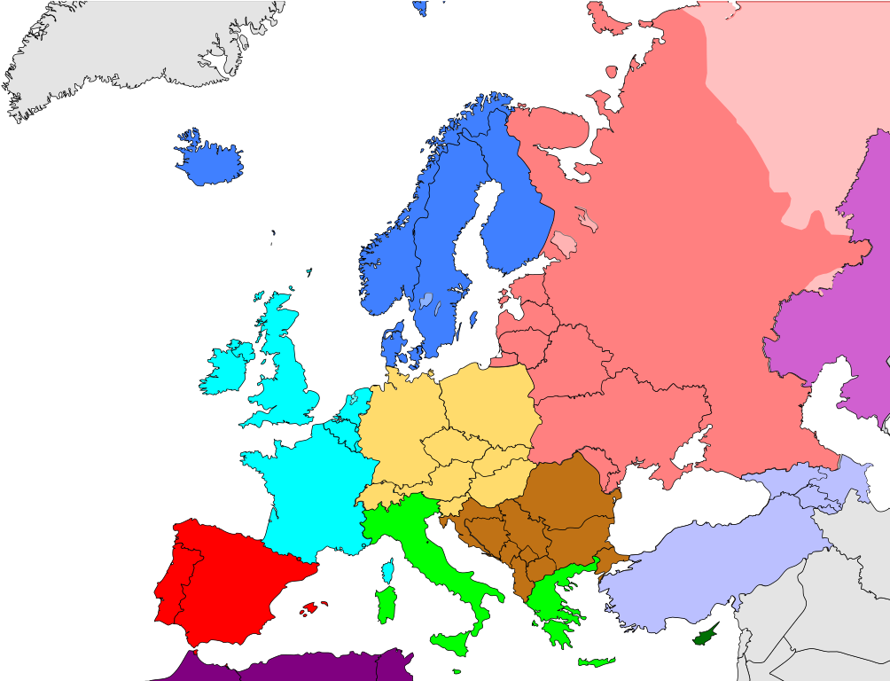
Deutsch: Subregionen Europas (nach The World Factbook)
Nordeuropa
Westeuropa
Mitteleuropa
Südeuropa
Südosteuropa
Südwesteuropa
Osteuropa English: Subregions of Europe (
The World Factbook)
Northern Europe
Western Europe
Central Europe
Southern Europe
Southeastern Europe
Southwestern Europe
Eastern Europe
Northwest Africa
Southwestern Asia
Northern Asia
Central Asia
Middle East Català: Subregions d'Europa (extret de The World Factbook,
CIA)
Europa Septentrional
Europa Occidental
Europa Central
Europa Meridional
Sudest d'Europa
Sudoest d'Europa
Europa Oriental
Àfrica del Noroest
Sudoest d'Àsia
Àsia Septentrional
Àsia Central
Orient Mitjà Español: Subregiones de Europa (The World Factbook)
Europa Septentrional
Europa Occidental
Europa Central
Europa Meridional
Sudeste de Europa
Sudoeste de Europa
Europa Oriental
África del Noroeste
Sudoeste Asiático
Asia Septentrional
Asia Central
Oriente Medio Français : Régions d'Europe (selon
The World Factbook, publication de la
CIA)
Europe du Nord
Europe de l'Ouest
Europe centrale
Europe du Sud
Europe du Sud-Est
Europe du Sud-Ouest
Europe de l'Est
Afrique du Nord-Ouest
Asie du Sud-Ouest
Asie du Nord
Asie centrale
Moyen-Orient Português: Sub-regiões da Europa (The World Factbook)
Europa Setentrional
Europa Ocidental
Europa Central
Europa Meridional
Sudeste da Europa
Sudoeste da Europa
Europa Oriental
África do Noroeste
Sudoeste da Ásia
Ásia Setentrional
Ásia Central
Oriente Médio Magyar: Európa alrégiói (
The World Factbook)
Észak-Európa
Nyugat-Európa
Közép-Európa
Dél-Európa
Délkelet-Európa
Délnyugat-Európa
Kelet-Európa
Északnyugat-Afrika
Délnyugat-Ázsia
Észak-Ázsia
Közép-Ázsia
Közel-Kelet |
| Date | |
| Source | Own work |
| Author | Kolja21 |
| Other versions |
|


_de.png)
.png)


Licensing
I, the copyright holder of this work, hereby publish it under the following license:
This file is licensed under the
Creative Commons
Attribution 3.0 Unported license.
- You are free:
- to share – to copy, distribute and transmit the work
- to remix – to adapt the work
- Under the following conditions:
- attribution – You must give appropriate credit, provide a link to the license, and indicate if changes were made. You may do so in any reasonable manner, but not in any way that suggests the licensor endorses you or your use.
File history
Click on a date/time to view the file as it appeared at that time.
| Date/Time | Thumbnail | Dimensions | User | Comment | |
|---|---|---|---|---|---|
| current | 10:44, 25 January 2021 |
| 680 × 520 (230 KB) | TU-nor | Corrected Malta |
| 19:41, 30 June 2018 |
 | 680 × 520 (576 KB) | Asmodim | Added North Africa region | |
| 12:14, 31 July 2017 |
 | 680 × 520 (574 KB) | TU-nor | Corrected Switzerland (to Central Europe) and Andorra (to Southwestern Europe) according to CIA source | |
| 19:47, 17 December 2009 |
 | 680 × 520 (574 KB) | Kolja21 | rev Please make new map, if you don't like this one | |
| 22:22, 16 December 2009 |
 | 680 × 520 (575 KB) | Koyos | colors were incorrect according to source, now fixed, see discussion | |
| 18:42, 27 May 2009 |
 | 680 × 520 (574 KB) | Kolja21 | {{Information |Description={{en|1=Subregions of Europe ( en:The World Factbook}} {{de|1=Subregionen Europas (nach ''World Factbook'')}} |Source=Eigenes Werk (own work) |Author= Kolja21 |Date=2009-05-23 |Permission= |other_versions={{Us |
File usage
The following pages on the English Wikipedia use this file (pages on other projects are not listed):
Global file usage
The following other wikis use this file:
- Usage on ace.wikipedia.org
- Usage on af.wikipedia.org
- Usage on ar.wikipedia.org
- Usage on awa.wikipedia.org
- Usage on ba.wikipedia.org
- Usage on bn.wikipedia.org
- Usage on cs.wikipedia.org
- Usage on da.wikipedia.org
- Usage on de.wikipedia.org
- Usage on de.wiktionary.org
- Usage on el.wikipedia.org
- Usage on es.wikipedia.org
- Usage on fa.wikipedia.org
- Usage on fr.wikipedia.org
- Usage on fr.wiktionary.org
- Usage on hak.wikipedia.org
- Usage on he.wikipedia.org
- Usage on hi.wikipedia.org
- Usage on hu.wikipedia.org
- Usage on hy.wikipedia.org
- Usage on id.wikipedia.org
- Usage on incubator.wikimedia.org
- Usage on ja.wikipedia.org
View more global usage of this file.