
Size of this PNG preview of this SVG file:
800 × 465 pixels. Other resolutions:
320 × 186 pixels |
640 × 372 pixels |
1,024 × 595 pixels |
1,280 × 744 pixels |
2,560 × 1,488 pixels |
1,020 × 593 pixels.
Original file (SVG file, nominally 1,020 × 593 pixels, file size: 85 KB)
| This is a file from the
Wikimedia Commons. Information from its
description page there is shown below. Commons is a freely licensed media file repository. You can help. |
| U.S. presidential election maps (SVG) |
| See also: National Atlas maps (png) |
|
1789 · 1792 · 1796 · 1800 · 1804 · 1808 · 1812 · 1816 · 1820 · 1824 · 1828 · 1832 · 1836 · 1840 · 1844 · 1848 · 1852 · 1856 · 1860 · 1864 · 1868 · 1872 · 1876 · 1880 · 1884 · 1888 · 1892 · 1896 · 1900 · 1904 · 1908 · 1912 · 1916 · 1920 · 1924 · 1928 · 1932 · 1936 · 1940 · 1944 · 1948 · 1952 · 1956 · 1960 · 1964 · 1968 · 1972 · 1976 · 1980 · 1984 · 1988 · 1992 · 1996 · 2000 · 2004 · 2008 · 2012 · 2016 · 2020 · 2024 |
Summary
| Description |
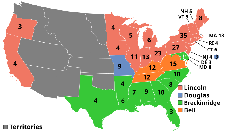
English: 1860 Electoral College |
| Date | Unknown date |
| Source | Own work http://www.270towin.com/1860_Election/ |
| Author | AndyHogan14 |
Licensing
| I, the copyright holder of this work, release this work into the
public domain. This applies worldwide. In some countries this may not be legally possible; if so: I grant anyone the right to use this work for any purpose, without any conditions, unless such conditions are required by law. |
File history
Click on a date/time to view the file as it appeared at that time.
| Date/Time | Thumbnail | Dimensions | User | Comment | |
|---|---|---|---|---|---|
| current | 13:49, 8 November 2011 |
| 1,020 × 593 (85 KB) | Citypeek | removal line |
| 20:08, 31 December 2008 |
 | 1,020 × 593 (114 KB) | AndyHogan14 | {{Information |Description= |Source= |Date= |Author= |Permission= |other_versions= }} | |
| 20:06, 31 December 2008 |
 | 1,020 × 593 (114 KB) | AndyHogan14 | {{Information |Description= |Source= |Date= |Author= |Permission= |other_versions= }} | |
| 20:05, 31 December 2008 |
 | 1,020 × 593 (114 KB) | AndyHogan14 | {{Information |Description={{en|1=1860 Electoral College}} |Source=Own work |Author= AndyHogan14 |Date= |Permission= |other_versions= }} <!--{{ImageUpload|full}}--> |
File usage
The following pages on the English Wikipedia use this file (pages on other projects are not listed):
- 1860 United States elections
- 1860 United States presidential election
- 1860 United States presidential election in Alabama
- 1860 United States presidential election in Arkansas
- 1860 United States presidential election in California
- 1860 United States presidential election in Connecticut
- 1860 United States presidential election in Delaware
- 1860 United States presidential election in Florida
- 1860 United States presidential election in Georgia
- 1860 United States presidential election in Illinois
- 1860 United States presidential election in Indiana
- 1860 United States presidential election in Iowa
- 1860 United States presidential election in Kentucky
- 1860 United States presidential election in Louisiana
- 1860 United States presidential election in Maine
- 1860 United States presidential election in Maryland
- 1860 United States presidential election in Massachusetts
- 1860 United States presidential election in Michigan
- 1860 United States presidential election in Minnesota
- 1860 United States presidential election in Mississippi
- 1860 United States presidential election in Missouri
- 1860 United States presidential election in New Hampshire
- 1860 United States presidential election in New Jersey
- 1860 United States presidential election in New York
- 1860 United States presidential election in North Carolina
- 1860 United States presidential election in Ohio
- 1860 United States presidential election in Oregon
- 1860 United States presidential election in Pennsylvania
- 1860 United States presidential election in Rhode Island
- 1860 United States presidential election in South Carolina
- 1860 United States presidential election in Tennessee
- 1860 United States presidential election in Texas
- 1860 United States presidential election in Vermont
- 1860 United States presidential election in Virginia
- 1860 United States presidential election in Wisconsin
- Abraham Lincoln
- Constitutional Union Party (United States)
- Electoral vote changes between United States presidential elections
- John C. Breckinridge
- List of United States presidential election results by state
- Origins of the American Civil War
- Political career of Abraham Lincoln (1849–1861)
- Political career of John C. Breckinridge
- Presidency of Abraham Lincoln
- Stephen A. Douglas
- United States presidential election
- User:DukeOfDelTaco/U.S. Presidential Elections
- User:Eddie891/1860 presidential election
- User:Gray-eyed Athena/sandbox
- User:Orser67/Lincoln
- User:TheVirginiaHistorian/sandbox
- Wikipedia:Graphics Lab/Illustration workshop/Archive/Nov 2011
- Template:1860 United States presidential election imagemap
- Template:State results of the 1860 U.S. presidential election
Global file usage
The following other wikis use this file:
- Usage on ar.wikipedia.org
- Usage on ca.wikipedia.org
- Usage on da.wikipedia.org
- Usage on de.wikipedia.org
- Usage on el.wikipedia.org
- Usage on en.wikibooks.org
- Usage on es.wikipedia.org
- Usage on eu.wikipedia.org
- Usage on fa.wikipedia.org
- Usage on fi.wikipedia.org
- Usage on fr.wikipedia.org
- Usage on gl.wikipedia.org
- Usage on he.wikipedia.org
- Usage on hu.wikipedia.org
- Usage on it.wikipedia.org
- Usage on ja.wikipedia.org
- Usage on ko.wikipedia.org
- Usage on la.wikipedia.org
- Usage on lv.wikipedia.org
- Usage on mk.wikipedia.org
- Usage on mr.wikipedia.org
- Usage on nl.wikipedia.org
- Usage on no.wikipedia.org
- Usage on oc.wikipedia.org
- Usage on pl.wikipedia.org
- Usage on pt.wikipedia.org
- Usage on ro.wikipedia.org
View more global usage of this file.