Size of this preview:
800 × 387 pixels. Other resolutions:
320 × 155 pixels |
923 × 447 pixels.
Original file (923 × 447 pixels, file size: 80 KB, MIME type: image/png)
| This is a file from the
Wikimedia Commons. Information from its
description page there is shown below. Commons is a freely licensed media file repository. You can help. |
Summary
| Description |
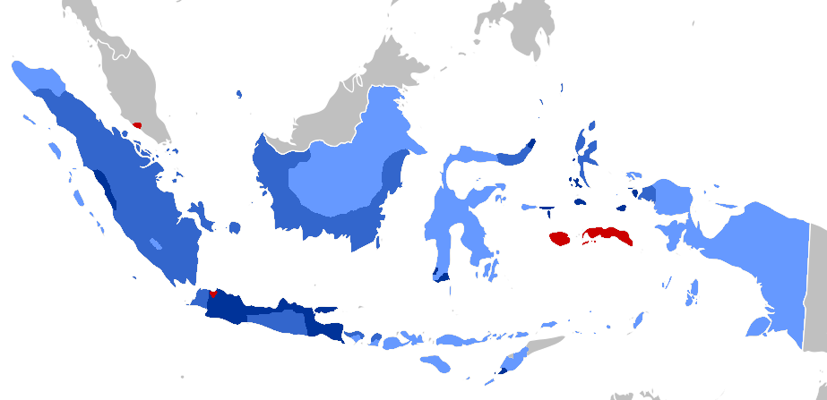
Afrikaans: Periodisering van
VOC-territoriale uitbreiding (1619–), en
Nederlands-Indië beginnend by 1800:
1600s
1700s
1800s
1900-1942 English: Periodization of VOC territorial expansion, and Dutch East Indies Period from 1800:
1600s
1700s
1800s
1900-1942 Bahasa Indonesia: Periodisasi ekspansi wilayah VOC (1619-1800), Masa Hindia Belanda (1800–1949/1963)
1600an
1700an
1800an
1900-1942 |
| Date | |
| Source |
The coloring (with GIMP) is based on two maps: The base map is from File:BlankMap-World.svg |
| Author | Adhiansyah Ancha |
Licensing
| |
This work has been released into the
public domain by its author,
Adhiansyah Ancha, at the
Indonesian Wikipedia project. This applies worldwide. In case this is not legally possible: |
File history
Click on a date/time to view the file as it appeared at that time.
| Date/Time | Thumbnail | Dimensions | User | Comment | |
|---|---|---|---|---|---|
| current | 10:00, 8 April 2020 |
| 923 × 447 (80 KB) | AnsyahF | Uploaded a work by Adhiansyah Ancha from The coloring (with GIMP) is based on two maps: 1. File:Territorial_Evolution_of_the_Dutch_East_Indies.png 2. File:Dutch_East_Indies_Expansion.gif The base map is from File:BlankMap-World.svg with UploadWizard |
File usage
The following pages on the English Wikipedia use this file (pages on other projects are not listed):
Global file usage
The following other wikis use this file:
- Usage on arz.wikipedia.org
- Usage on ban.wikipedia.org
- Usage on id.wikipedia.org
- Usage on sq.wikipedia.org