
Original file (4,928 × 2,033 pixels, file size: 3.17 MB, MIME type: image/jpeg)
| This is a file from the
Wikimedia Commons. Information from its
description page there is shown below. Commons is a freely licensed media file repository. You can help. |
Summary
| Description |
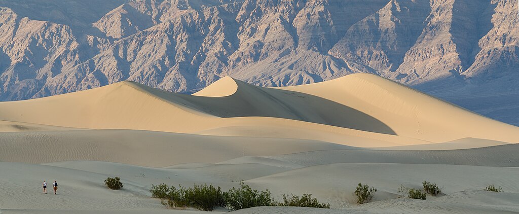
Deutsch: Mesquite Flats Sand Dunes im Death Valley English: Mesquite Flats Sand Dunes in Death Valley |
| Date | |
| Source | Own work |
| Author | Tuxyso |
| Attribution ( required by the license) | Tuxyso / Wikimedia Commons / |
| Camera location |
| View this and other nearby images on: OpenStreetMap |
|
|---|
|
This image was selected as
picture of the day on Wikimedia Commons for
4 December 2013. It was captioned as follows: English: Mesquite Flats Sand Dunes in
Death Valley. Other languages:
Bahasa Melayu: Gumuk pasir Mesquite Flats di Lembah Maut,
California Bosanski: Pješčane dine na Mesquite Flats u
Dolini smrti. Deutsch: Mesquite Flats Sanddünen im
Death-Valley-Nationalpark. English: Mesquite Flats Sand Dunes in
Death Valley. Русский: Песчаные дюны в
Долине Смерти (Калифорния). 中文: 美国
死亡谷沙丘。 |
Licensing
- You are free:
- to share – to copy, distribute and transmit the work
- to remix – to adapt the work
- Under the following conditions:
- attribution – You must give appropriate credit, provide a link to the license, and indicate if changes were made. You may do so in any reasonable manner, but not in any way that suggests the licensor endorses you or your use.
- share alike – If you remix, transform, or build upon the material, you must distribute your contributions under the same or compatible license as the original.
|
Dieses Foto ist vom Wikimedia Commons Nutzer Tuxyso. Achtung: Dieses Bild ist nicht gemeinfrei. Es ist zwar frei benutzbar aber gesetzlich geschützt. |
This photo was created by Wikimedia Commons user Tuxyso. Note: this image is not in the Public Domain. It is free to use but protected by law. |
||
|
|
Bitte benutzen sie nach Möglichkeit in der Bildbeschreibung: Tuxyso / Wikimedia Commons / CC-BY-SA-3.0 in unmittelbarer Nähe beim Bild oder an einer Stelle in ihrer Publikation, wo dies üblich ist. Dabei muß der Zusammenhang zwischen Bild und Urhebernennung gewahrt bleiben. |
I prefer the following credit: Tuxyso / Wikimedia Commons / CC-BY-SA-3.0 near to the photo or at a location that is common in your publication but preserving the association between image and credit. |
 |
|
Bitte lesen sie den Lizenztext gründlich, bevor sie das Bild nutzen! Wenn sie Fragen zu den Lizenzvereinbarungen haben oder mich auf eine interessante Nachnutzung hinweisen möchten, kontaktieren sie mich bitte per Mail: tuxyso@gmail.com. |
Please review the license requirements carefully before using this image. If you would like to clarify the license terms or inform me about a reuse of the image (which is always interesting for me), please contact me by email: tuxyso@gmail.com. |
||

File history
Click on a date/time to view the file as it appeared at that time.
| Date/Time | Thumbnail | Dimensions | User | Comment | |
|---|---|---|---|---|---|
| current | 08:09, 18 October 2013 |
| 4,928 × 2,033 (3.17 MB) | Tuxyso | slight brightness adjustments, slightly modified WB |
| 22:33, 26 September 2013 |
 | 4,928 × 2,033 (2.93 MB) | Tuxyso | User created page with UploadWizard |
File usage
Global file usage
The following other wikis use this file:
- Usage on af.wikipedia.org
- Usage on ar.wikipedia.org
- Usage on arz.wikipedia.org
- Usage on be-tarask.wikipedia.org
- Usage on bg.wikipedia.org
- Usage on bn.wikipedia.org
- Usage on br.wikipedia.org
- Usage on ca.wikipedia.org
- Usage on ceb.wikipedia.org
- Usage on crh.wikipedia.org
- Usage on cv.wikipedia.org
- Usage on de.wikivoyage.org
- Usage on en.wikiversity.org
- Usage on en.wiktionary.org
- Usage on es.wikipedia.org
- Usage on fa.wikipedia.org
- Usage on fo.wikipedia.org
- Usage on fr.wikipedia.org
- Usage on he.wikipedia.org
- Usage on hu.wikipedia.org
- Usage on id.wikipedia.org
- Usage on is.wikipedia.org
- Usage on ja.wikipedia.org
- Usage on ka.wikipedia.org
- Usage on ko.wikipedia.org
- Usage on krc.wikipedia.org
- Usage on lbe.wikipedia.org
- Usage on lv.wikipedia.org
- Usage on mai.wikipedia.org
- Usage on ne.wikipedia.org
- Usage on os.wikipedia.org
- Usage on pt.wikipedia.org
- Usage on ru.wikipedia.org
View more global usage of this file.