
Size of this JPG preview of this TIF file:
426 × 599 pixels. Other resolutions:
171 × 240 pixels |
341 × 480 pixels |
546 × 768 pixels |
728 × 1,024 pixels |
1,457 × 2,048 pixels |
3,557 × 5,000 pixels.
Original file (3,557 × 5,000 pixels, file size: 16.96 MB, MIME type: image/tiff)
| This is a file from the
Wikimedia Commons. Information from its
description page there is shown below. Commons is a freely licensed media file repository. You can help. |
Summary
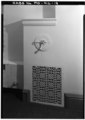
| DETAIL SHOWING GRILLE, AND CONTROL FOR AIR DUCT, FIRST FLOOR, CENTRAL ROOM, EAST WALL - Montgomery County Courthouse (1891), Court House Square, Rockville, Montgomery County, MD | ||||
|---|---|---|---|---|
| Title |
DETAIL SHOWING GRILLE, AND CONTROL FOR AIR DUCT, FIRST FLOOR, CENTRAL ROOM, EAST WALL - Montgomery County Courthouse (1891), Court House Square, Rockville, Montgomery County, MD |
|||
| Description |
Boucher, Jack E, photographer; Jandoli, Liz, transmitter |
|||
| Depicted place | Maryland; Montgomery County; Rockville | |||
| Date | Documentation compiled after 1933 | |||
| Dimensions | 5 x 7 in. | |||
| Current location |
Library of Congress Prints and Photographs Division Washington, D.C. 20540 USA
http://hdl.loc.gov/loc.pnp/pp.print |
|||
| Accession number |
HABS MD,16-ROCVI,4-18 |
|||
| Credit line |
|
|||
| Notes |
|
|||
| Source | https://www.loc.gov/pictures/item/md0990.photos.082664p | |||
| Permission ( Reusing this file) |
|
|||

| Object location |
| View this and other nearby images on: OpenStreetMap |
|
|---|
File history
Click on a date/time to view the file as it appeared at that time.
| Date/Time | Thumbnail | Dimensions | User | Comment | |
|---|---|---|---|---|---|
| current | 17:46, 22 July 2014 |
 | 3,557 × 5,000 (16.96 MB) | Fæ | GWToolset: Creating mediafile for Fæ. HABS 21 July 2014 (1601:1800) |
File usage
The following pages on the English Wikipedia use this file (pages on other projects are not listed):
Global file usage
The following other wikis use this file:
- Usage on id.wikipedia.org