
Size of this preview:
774 × 600 pixels. Other resolutions:
310 × 240 pixels |
619 × 480 pixels |
991 × 768 pixels |
1,280 × 992 pixels |
2,000 × 1,550 pixels.
Original file (2,000 × 1,550 pixels, file size: 700 KB, MIME type: image/jpeg)
| This is a file from the
Wikimedia Commons. Information from its
description page there is shown below. Commons is a freely licensed media file repository. You can help. |
Summary
| Description |
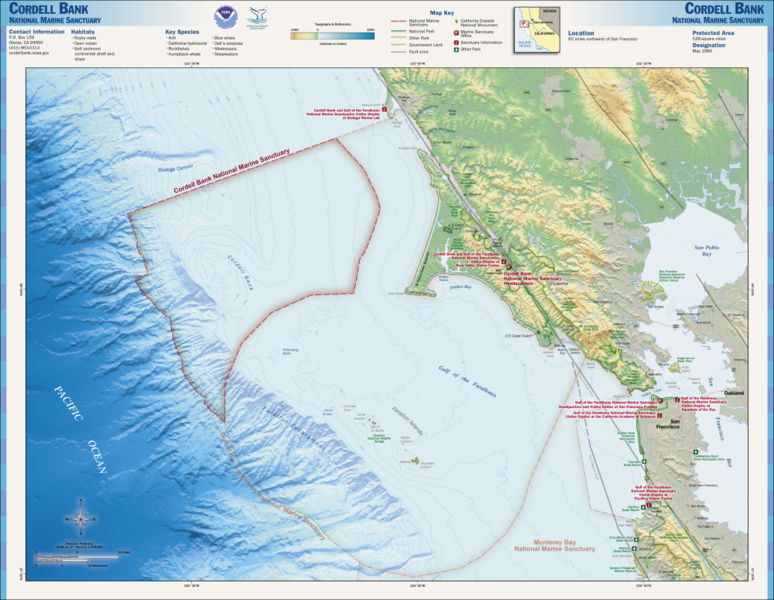
English: Map of the
Cordell Bank National Marine Sanctuary — Northern California.
|
| Date | Unknown date |
| Source | http://www.sanctuaries.noaa.gov/pgallery/atlasmaps/cb.html |
| Author | NOAA, National Marine Sanctuaries |
| Permission ( Reusing this file) |
PD-USGov-NOAA |
Licensing
This image is in the
public domain because it contains materials that originally came from the U.S.
National Oceanic and Atmospheric Administration, taken or made as part of an employee's official duties.
|
en:Cordell Bank National Marine Sanctuary
File history
Click on a date/time to view the file as it appeared at that time.
| Date/Time | Thumbnail | Dimensions | User | Comment | |
|---|---|---|---|---|---|
| current | 01:31, 17 October 2006 |
| 2,000 × 1,550 (700 KB) | Davepape | {{Information |Description=Map of the Cordell Bank National Marine Sanctuary |Source=http://www.sanctuaries.noaa.gov/pgallery/atlasmaps/cb.html |Date= |Author=NOAA, National Marine Sanctuaries |Permission=PD |
File usage
The following pages on the English Wikipedia use this file (pages on other projects are not listed):
Global file usage
The following other wikis use this file:
- Usage on de.wikipedia.org
- Usage on it.wikipedia.org
- Usage on pl.wikipedia.org
- Usage on ru.wikipedia.org
- Usage on uk.wikipedia.org