No higher resolution available.
Castle_Island_and_Fort_Orange_Albany,_New_York_1629.jpg (200 × 147 pixels, file size: 16 KB, MIME type: image/jpeg)
| This is a file from the
Wikimedia Commons. Information from its
description page there is shown below. Commons is a freely licensed media file repository. You can help. |
Summary
| Description |
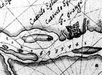
English: A 1629 map of Albany, New York area showing Fort Orange and Castle Island; the original is in the Library of Congress. |
| Date | original map made in 1629, downloaded to wikipedia in 2008 |
| Source | New York State Museum website |
| Author | unknown |
Licensing
|
This is a faithful photographic reproduction of a two-dimensional,
public domain work of art. The work of art itself is in the public domain for the following reason:
The official position taken by the Wikimedia Foundation is that "faithful reproductions of two-dimensional public domain works of art are public domain".
This photographic reproduction is therefore also considered to be in the public domain in the United States. In other jurisdictions, re-use of this content may be restricted; see Reuse of PD-Art photographs for details. |


Original upload log
Transferred from en.wikipedia to Commons by Sreejithk2000 using CommonsHelper.
The original description page was
here. All following user names refer to en.wikipedia.
- 2008-12-13 18:43 Camelbinky 200×147× (16436 bytes) {{Information |Description= |Source= |Date= |Author= |Permission= |other_versions= }}
File history
Click on a date/time to view the file as it appeared at that time.
| Date/Time | Thumbnail | Dimensions | User | Comment | |
|---|---|---|---|---|---|
| current | 08:00, 2 June 2010 |
| 200 × 147 (16 KB) | File Upload Bot (Magnus Manske) | {{BotMoveToCommons|en.wikipedia|year={{subst:CURRENTYEAR}}|month={{subst:CURRENTMONTHNAME}}|day={{subst:CURRENTDAY}}}} {{Information |Description={{en|A 1629 map of Albany, New York area showing Fort Orange and Castle Island; the original is in the Libra |
File usage
The following pages on the English Wikipedia use this file (pages on other projects are not listed):
Global file usage
The following other wikis use this file:
- Usage on bg.wikipedia.org
- Usage on et.wikipedia.org
- Usage on fr.wikipedia.org
- Usage on no.wikipedia.org
- Usage on www.wikidata.org