
Size of this preview:
450 × 600 pixels. Other resolutions:
180 × 240 pixels |
360 × 480 pixels |
576 × 768 pixels |
768 × 1,024 pixels |
1,536 × 2,048 pixels |
3,024 × 4,032 pixels.
Original file (3,024 × 4,032 pixels, file size: 6.25 MB, MIME type: image/jpeg)
| This is a file from the
Wikimedia Commons. Information from its
description page there is shown below. Commons is a freely licensed media file repository. You can help. |
.jpg)
Summary
| Description |
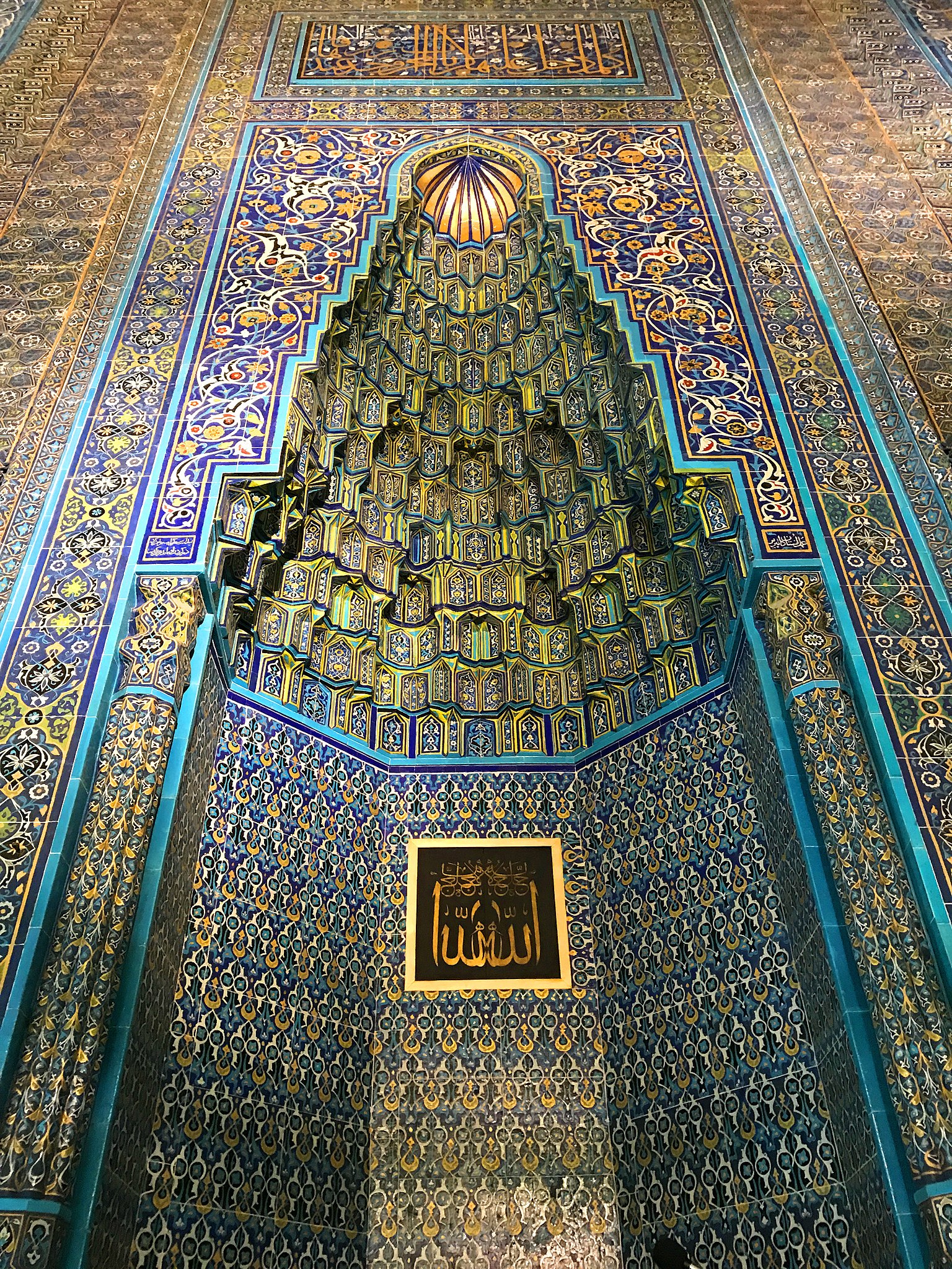
Türkçe: Bursa Yeşil Camii, 2017.
Bursa Yeşil Camii, Bursa’da ilk dönem Osmanlı mimarisinin önemli örnekleri arasında yer alan bir tarihi yapı. Caminin ünü, çini kaplamalarından gelir.
العربية: الجامع الأخضر، بورصة، تركيا 2017.
الجامع الأخضر، واسمه في تركيا "يشيل جامع"، ويُعرف أيضاً باسم "جامع السلطان محمد الأول" الذي أنشأ هذا المسجد بعد أن وَحَّدَ الدولة العثمانية عقب الحروب الأهلية (عهد الفترة) التي تلت موت أبيه السلطان بايزيد الأول في الأسر والتي استمرت 11 عاما. يقع الجامع الأخضر في الجانب الشرقي من مدينة بورصة التي كانت عاصمة العثمانيين حتى قبيل فتح القسطنطينية عام 1453م، والجامع جزء من كُلِّيّة أي مجموعة كبيرة من أبنية تتكون من مسجد ومقام ومدرسة ومطبخ عام وحمام عام. جائت التسمية "بالأخضر" نِسبة إلى استخدام اللون الأخضر في الزينة الداخلية للجامع والبلاط الأخضر على الجدران، وحاليا تم إضافة سجاد أخضر بالمسجد ليحافظ على الروح العامة للجامع.
English: Green Mosque of Bursa, Turkey, 2017.
Green Mosque (Turkish: Yeşil Camii, "Yeşil Mosque"), also known as Mosque of Sultan Mehmed I, is a part of the larger complex (a külliye) located on the east side of Bursa, Turkey, the former capital of the Ottoman Turks before they captured Constantinople in 1453. The complex consists of a mosque, türbe, madrasah, kitchen and bath. |
| Date | |
| Source | Own work |
| Author | Yahia.Mokhtar |
| Camera location |
| View this and other nearby images on: OpenStreetMap |
|
|---|
.jpg¶ms=040.181983_N_0029.074614_E_globe:Earth_type:camera__&language=en)
Licensing
I, the copyright holder of this work, hereby publish it under the following license:
This file is licensed under the
Creative Commons
Attribution-Share Alike 4.0 International license.
- You are free:
- to share – to copy, distribute and transmit the work
- to remix – to adapt the work
- Under the following conditions:
- attribution – You must give appropriate credit, provide a link to the license, and indicate if changes were made. You may do so in any reasonable manner, but not in any way that suggests the licensor endorses you or your use.
- share alike – If you remix, transform, or build upon the material, you must distribute your contributions under the same or compatible license as the original.
File history
Click on a date/time to view the file as it appeared at that time.
| Date/Time | Thumbnail | Dimensions | User | Comment | |
|---|---|---|---|---|---|
| current | 02:44, 30 January 2018 |
| 3,024 × 4,032 (6.25 MB) | "Yahia" | User created page with UploadWizard |
File usage
The following pages on the English Wikipedia use this file (pages on other projects are not listed):
Global file usage
The following other wikis use this file:
- Usage on ar.wikipedia.org
- Usage on el.wikipedia.org
- Usage on es.wikipedia.org
- Usage on fr.wikipedia.org
- Usage on ja.wikipedia.org
- Usage on ml.wikipedia.org
- Usage on pl.wikipedia.org
- Usage on sl.wikipedia.org
- Usage on sr.wikipedia.org
.jpg)