Size of this preview:
799 × 599 pixels. Other resolutions:
320 × 240 pixels |
640 × 480 pixels |
1,024 × 768 pixels |
1,280 × 960 pixels |
2,560 × 1,920 pixels |
3,573 × 2,680 pixels.
Original file (3,573 × 2,680 pixels, file size: 5.54 MB, MIME type: image/jpeg)
| This is a file from the
Wikimedia Commons. Information from its
description page there is shown below. Commons is a freely licensed media file repository. You can help. |
|
| This is a featured picture, which means that members of the community have identified it as one of the finest images on the English Wikipedia, adding significantly to its accompanying article. If you have a different image of similar quality, be sure to upload it using the proper free license tag, add it to a relevant article, and nominate it. |
|
| This image was selected as picture of the day on the English Wikipedia for January 19, 2022. |
| Description |
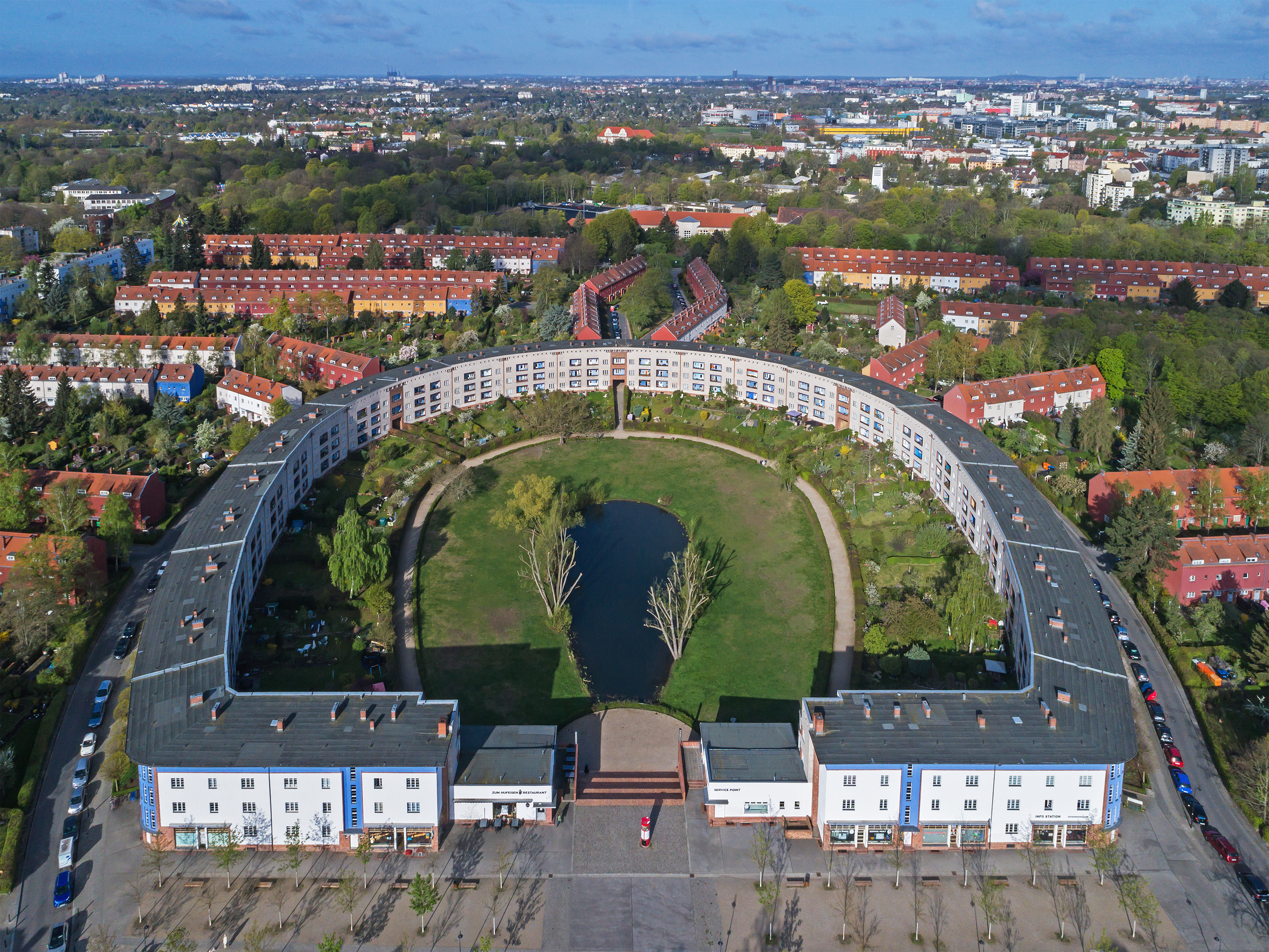
English: Aerial view of the «Horseshoe Block» in Berlin (Germany), looking west
Español: Vista aérea de la «
herradura», una urbanización diseñada por el arquitecto
Bruno Taut en
Berlín, Alemania.
Deutsch: Luftaufnahme der Hufeisensiedlung in Berlin (Deutschland) mit Blickrichtung Westen
Polski: Widok z powietrza na zaprojektowane przez
Bruno Tauta
Osiedle Podkowy (
niem. Hufeisensiedlung) w
Berlinie, w
Niemczech.
Русский: Аэрофотосъёмка «Дома-подковы» в Берлине (Германия) |
| Date | |
| Source | Own work |
| Author | A.Savin |
| Permission ( Reusing this file) |
.svg) Just attribute the author: «A.Savin, Wikipedia»; if you have questions —
Telegram, or e-mail to wikiphotospace@gmail.com..svg) Просто укажите в качестве автора: «А.Савин, Википедия»; если есть вопрос —
телеграм, или эл.почта на wikiphotospace@gmail.com. Kennzeichnen Sie einfach als Autor: «A.Savin, Wikipedia»; falls Sie Fragen haben —
Telegram, oder E-Mail an wikiphotospace@gmail.com.
Thank you. |
| Camera location |
| View this and other nearby images on: OpenStreetMap |
|
|---|
|
This image was selected as
picture of the day on Wikimedia Commons for
29 November 2018. It was captioned as follows: Other languages:
Español: Vista aérea de la «
herradura», una urbanización diseñada por el arquitecto
Bruno Taut en
Berlín, Alemania. Italiano: Vista aerea dell'
Hufeisensiedlung ("insediamento a ferro di cavallo"), un grande complesso residenziale di
Berlino progettato da
Bruno Taut. Nederlands: De
Hufeisensiedlung (Hoefijzernederzetting) van
Bruno Taut in de Duitse hoofdstad
Berlijn Polski: Widok z powietrza na zaprojektowane przez
Bruno Tauta
Osiedle Podkowy (
niem. Hufeisensiedlung) w
Berlinie, w
Niemczech. Português: Vista aérea da "Ferradura" (Hufeisensiedlung), um assentamento de
habitação social construído entre 1925 e 1933 em várias fases e projetado pelo arquiteto
Bruno Taut em
Berlim, Alemanha. Македонски: Станбениот комплекс „
Потковица“ во Берлин — дело на
Бруно Таут проектирано во 1920-тите. فارسی : persian |
| Annotations | This image is annotated: View the annotations at Commons |
Licensing
| Copyleft: This work of art is free; you can redistribute it and/or modify it according to terms of the Free Art License. You will find a specimen of this license on the Copyleft Attitude site as well as on other sites. |
File history
Click on a date/time to view the file as it appeared at that time.
| Date/Time | Thumbnail | Dimensions | User | Comment | |
|---|---|---|---|---|---|
| current | 02:02, 17 April 2017 |
| 3,573 × 2,680 (5.54 MB) | A.Savin | {{User:A.Savin/F |Description= {{en|Aerial view of the «Horseshoe Block» in Berlin (Germany)}} {{de|Luftaufnahme der Hufeisensiedlung in Berlin (Deutschland)}} {{ru|Аэрофотосъёмка «Дома-подковы» в Берлине (Герм... |
File usage
The following pages on the English Wikipedia use this file (pages on other projects are not listed):
- Architectural icon
- Berlin Modernism Housing Estates
- Britz
- Bruno Taut
- Horseshoe shape
- Hufeisensiedlung
- Modern architecture
- Neukölln
- Talk:Berlin Modernism Housing Estates
- User:Marsupium/topo/Berlin
- User talk:A.Savin
- User talk:MER-C/archives/48
- Wikipedia:Featured picture candidates/February-2020
- Wikipedia:Featured picture candidates/Hufeisensiedlung
- Wikipedia:Featured pictures/Places/Architecture
- Wikipedia:Featured pictures thumbs/66
- Wikipedia:Main Page history/2022 January 19
- Wikipedia:Main Page history/2022 January 19b
- Wikipedia:Picture of the day/January 2022
- Wikipedia:WikiProject Germany/Featured Content
- Template:POTD/2022-01-19
- Portal:Architecture/Recognized content
- Portal:Germany/Recognized content
- Portal:The arts/Recognized content
Global file usage
The following other wikis use this file:
- Usage on af.wikipedia.org
- Usage on az.wikipedia.org
- Usage on be-tarask.wikipedia.org
- Usage on crh.wikipedia.org
- Usage on cs.wikipedia.org
- Usage on cv.wikipedia.org
- Usage on de.wikipedia.org
- Usage on de.wikivoyage.org
- Usage on en.wikivoyage.org
- Usage on eo.wikipedia.org
- Usage on es.wikipedia.org
- Usage on eu.wikipedia.org
- Usage on fa.wikipedia.org
- Usage on fi.wikipedia.org
- Usage on fr.wikipedia.org
- Usage on fy.wikipedia.org
- Usage on gl.wikipedia.org
- Usage on he.wikipedia.org
- Usage on hu.wikipedia.org
- Usage on hy.wikipedia.org
- Usage on incubator.wikimedia.org
- Usage on it.wikipedia.org
- Usage on it.wikivoyage.org
- Usage on ja.wikipedia.org
View more global usage of this file.