
Size of this PNG preview of this SVG file:
800 × 417 pixels. Other resolutions:
320 × 167 pixels |
640 × 334 pixels |
1,024 × 534 pixels |
1,280 × 668 pixels |
2,560 × 1,335 pixels |
1,317 × 687 pixels.
Original file (SVG file, nominally 1,317 × 687 pixels, file size: 2.43 MB)
| This is a file from the
Wikimedia Commons. Information from its
description page there is shown below. Commons is a freely licensed media file repository. You can help. |
Summary
| Description |
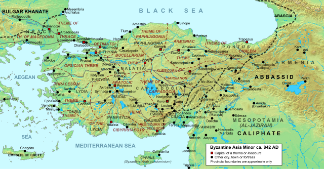
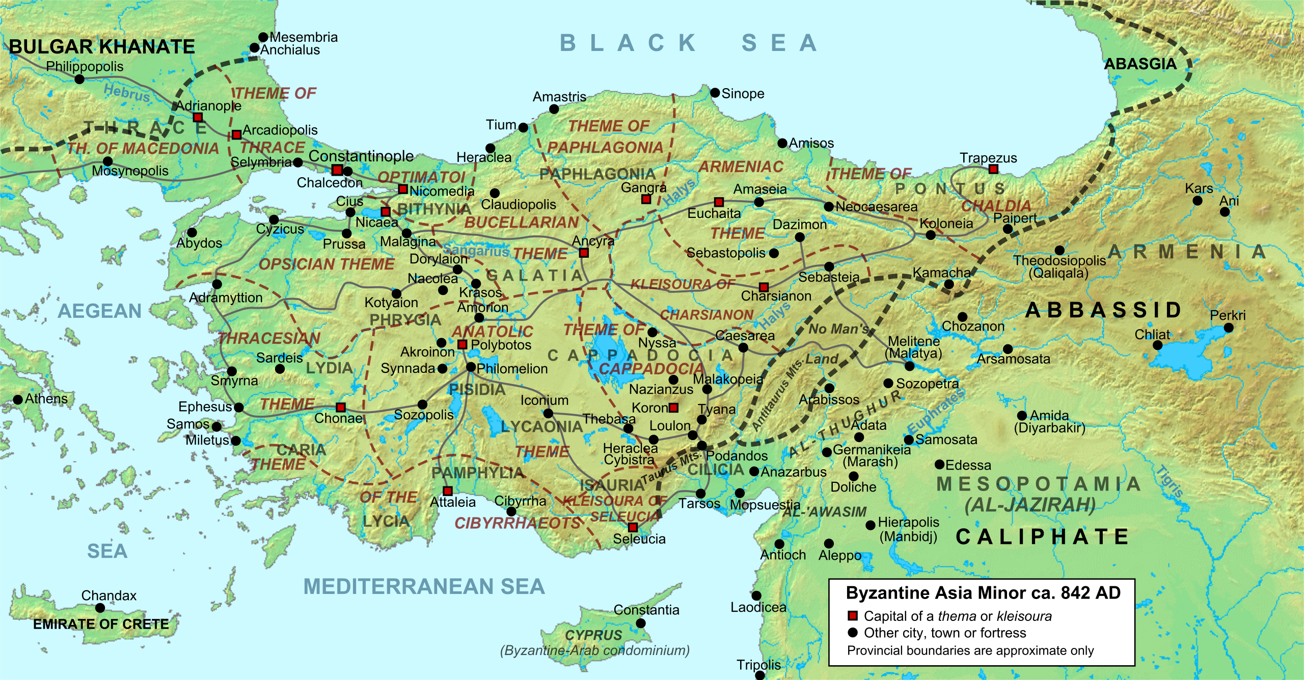
English: Byzantine Asia Minor (Anatolia) and the Byzantine-Arab frontier region in 842 AD, with provinces and major settlements. |
| Date | |
| Source |
Own work using:
|
| Author | Cplakidas |
| Other versions |
|
| SVG development |


Licensing
I, the copyright holder of this work, hereby publish it under the following licenses:
This file is licensed under the
Creative Commons
Attribution-Share Alike 3.0 Unported license.
- You are free:
- to share – to copy, distribute and transmit the work
- to remix – to adapt the work
- Under the following conditions:
- attribution – You must give appropriate credit, provide a link to the license, and indicate if changes were made. You may do so in any reasonable manner, but not in any way that suggests the licensor endorses you or your use.
- share alike – If you remix, transform, or build upon the material, you must distribute your contributions under the same or compatible license as the original.

|
Permission is granted to copy, distribute and/or modify this document under the terms of the GNU Free Documentation License, Version 1.2 or any later version published by the Free Software Foundation; with no Invariant Sections, no Front-Cover Texts, and no Back-Cover Texts. A copy of the license is included in the section entitled GNU Free Documentation License. |
You may select the license of your choice.
File history
Click on a date/time to view the file as it appeared at that time.
| Date/Time | Thumbnail | Dimensions | User | Comment | |
|---|---|---|---|---|---|
| current | 18:19, 10 June 2012 |
| 1,317 × 687 (2.43 MB) | Cplakidas | adding main river names |
| 07:03, 22 March 2012 |
 | 1,317 × 687 (2.4 MB) | Cplakidas | minor tweaks & corrections | |
| 10:25, 18 August 2011 |
 | 1,317 × 687 (2.4 MB) | Cplakidas | improved version | |
| 04:00, 26 September 2010 |
 | 1,317 × 687 (2.28 MB) | Cplakidas | {{Information |Description={{en|1=Byzantine Asia Minor (Anatolia) in 842 AD, with provinces and major settlements. Geophysical map taken from from [http://www2.demis.nl/ DEMIS Mapserver], which are public domain, other wise self-made. Sources: W. Treadgol |
File usage
The following pages on the English Wikipedia use this file (pages on other projects are not listed):
- Al-Abbas ibn al-Ma'mun
- Al-Wathiq
- Anatolia
- Anatolic Theme
- Armeniac Theme
- Battle of Bathys Ryax
- Battle of Lalakaon
- Battle of Mauropotamos
- Byzantine Anatolia
- Cappadocia (theme)
- Capture of Faruriyyah
- Chaldia
- Chrysocheir
- Cibyrrhaeot Theme
- Karbeas
- Nakoleia
- Palaiologos
- Paphlagonia (theme)
- Polybotus
- Skleros
- Theoktistos
- Thomas the Slav
- Umar al-Aqta
- User:Cplakidas/Articles
- User:Falcaorib
Global file usage
The following other wikis use this file:
- Usage on ar.wikipedia.org
- Usage on bg.wikipedia.org
- Usage on bn.wikipedia.org
- Usage on ca.wikipedia.org
- Usage on cs.wikipedia.org
- Usage on de.wikipedia.org
- Usage on el.wikipedia.org
- Usage on et.wikipedia.org
- Usage on fa.wikipedia.org
- Usage on fr.wikipedia.org
- Usage on hu.wikipedia.org
- Usage on id.wikipedia.org
- Usage on it.wikipedia.org
View more global usage of this file.