
Size of this preview:
404 × 599 pixels. Other resolutions:
162 × 240 pixels |
324 × 480 pixels |
518 × 768 pixels |
1,266 × 1,876 pixels.
Original file (1,266 × 1,876 pixels, file size: 1.38 MB, MIME type: image/jpeg)
| This is a file from the
Wikimedia Commons. Information from its
description page there is shown below. Commons is a freely licensed media file repository. You can help. |
|
This is an image of a place or building that is listed on the
National Register of Historic Places in the
United States of America. Its reference number is
72000812. |
Summary
| Description |
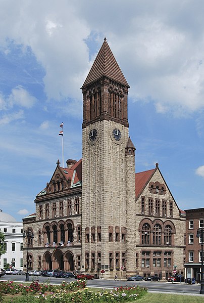
Français : L'hôtel de ville d'Albany, dans l’
état de New-York, aux États-Unis. |
| Date | |
| Source | Own work |
| Author | UpstateNYer |
| Object location |
| View this and other nearby images on: OpenStreetMap |
|
|---|
 |
This image or media was taken or created by
Matt H. Wade. To see his entire portfolio,
click here. @ thatmattwade
|
Licensing
I, the copyright holder of this work, hereby publish it under the following license:
This file is licensed under the
Creative Commons
Attribution 3.0 Unported license.
- You are free:
- to share – to copy, distribute and transmit the work
- to remix – to adapt the work
- Under the following conditions:
- attribution – You must give appropriate credit, provide a link to the license, and indicate if changes were made. You may do so in any reasonable manner, but not in any way that suggests the licensor endorses you or your use.

|
This image has been assessed under the valued image criteria and is considered the most valued image on Commons within the scope: Albany City Hall, New York (exterior). You can see its nomination here. |
This image has been assessed using the
Quality image guidelines and is considered a
Quality image.
|
File history
Click on a date/time to view the file as it appeared at that time.
| Date/Time | Thumbnail | Dimensions | User | Comment | |
|---|---|---|---|---|---|
| current | 00:42, 21 June 2010 |
| 1,266 × 1,876 (1.38 MB) | MattWade | Straigtened |
| 22:07, 4 June 2010 |
 | 1,295 × 1,910 (1.41 MB) | MattWade | New image taken at a different time (All America City signs up) | |
| 21:43, 26 May 2010 |
 | 1,919 × 2,532 (1,008 KB) | MattWade | Larger version and straightened. | |
| 22:32, 29 June 2009 |
 | 320 × 400 (147 KB) | MattWade | {{Information |Description={{en|1=asdf}} |Source=Own work by uploader |Author= Wadester16 |Date=asdf |Permission= |other_versions= }} <!--{{ImageUpload|full}}--> |
File usage
The following pages on the English Wikipedia use this file (pages on other projects are not listed):
- 134th New York State Legislature
- Administrative divisions of New York (state)
- Albany, New York
- Albany City Hall
- Architecture of Albany, New York
- Henry Hobson Richardson
- Lafayette Park Historic District
- List of incorporated places in New York's Capital District
- List of tallest buildings in Albany, New York
- National Register of Historic Places listings in Albany, New York
- Richardsonian Romanesque
- User:Frankie Rae/Test H
- User:MattWade/FPsVPs
- User:MattWade/FPsVPs/Content
- User:Ɱ/List of incorporated places in New York's Hudson Valley
- Wikipedia:WikiProject Capital District
- Wikipedia:WikiProject Capital District/Featured content
Global file usage
The following other wikis use this file:
- Usage on bn.wikipedia.org
- Usage on en.wikivoyage.org
- Usage on es.wikipedia.org
- Usage on es.wikivoyage.org
- Usage on fi.wikipedia.org
- Usage on fr.wikipedia.org
- Usage on incubator.wikimedia.org
- Usage on it.wikipedia.org
- Usage on ja.wikipedia.org
- Usage on nl.wikipedia.org
- Usage on pnb.wikipedia.org
- Usage on sv.wikipedia.org
- Usage on tr.wikipedia.org
- Usage on www.wikidata.org