
Size of this preview:
800 × 382 pixels. Other resolutions:
320 × 153 pixels |
640 × 306 pixels |
1,024 × 490 pixels |
1,280 × 612 pixels |
3,054 × 1,460 pixels.
Original file (3,054 × 1,460 pixels, file size: 1.44 MB, MIME type: image/png)
| This is a file from the
Wikimedia Commons. Information from its
description page there is shown below. Commons is a freely licensed media file repository. You can help. |
Summary
| Description |
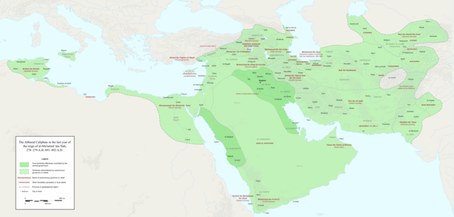
English: Map of the Abbasid Caliphate at the end of the reign of al-Mu'tamid in 891-892. Dark green denotes provinces under the effective control of the central government; light green denotes provinces under the control of autonomous governors or rebels.
The core Abbasid territories include Shahrazur, Darabadh, al-Samaghan, Hulwan, Masabadhan, Mihrijanqadhaq, the Euphrates districts, and Qarqisiyya (al-Tabari v. 37, p. 98; Bianquis p. 96). Map originally created as an .SVG file in Inkscape and converted to .PNG for size reasons. Background topography taken from DEMIS Mapserver, which are public domain. Works Cited:
|
| Date | |
| Source | Own work |
| Author | Ro4444 |
| Other versions |
 |
Licensing
I, the copyright holder of this work, hereby publish it under the following license:
This file is licensed under the
Creative Commons
Attribution-Share Alike 4.0 International license.
- You are free:
- to share – to copy, distribute and transmit the work
- to remix – to adapt the work
- Under the following conditions:
- attribution – You must give appropriate credit, provide a link to the license, and indicate if changes were made. You may do so in any reasonable manner, but not in any way that suggests the licensor endorses you or your use.
- share alike – If you remix, transform, or build upon the material, you must distribute your contributions under the same or compatible license as the original.
File history
Click on a date/time to view the file as it appeared at that time.
| Date/Time | Thumbnail | Dimensions | User | Comment | |
|---|---|---|---|---|---|
| current | 23:18, 3 December 2017 |
| 3,054 × 1,460 (1.44 MB) | Ro4444 | Further color corrections |
| 22:50, 3 December 2017 |
 | 3,054 × 1,460 (1.44 MB) | Ro4444 | Color correction | |
| 21:11, 3 December 2017 |
 | 3,054 × 1,460 (1.44 MB) | Ro4444 | User created page with UploadWizard |
File usage
The following pages on the English Wikipedia use this file (pages on other projects are not listed):
Global file usage
The following other wikis use this file:
- Usage on ar.wikipedia.org
- Usage on de.wikiversity.org
- Usage on en.wikibooks.org
- Usage on et.wikipedia.org
- Usage on fa.wikipedia.org
- Usage on hy.wikipedia.org
- Usage on id.wikipedia.org
- Usage on ja.wikipedia.org
- Usage on no.wikipedia.org
- Usage on pt.wikipedia.org
- Usage on sco.wikipedia.org
- Usage on uk.wikipedia.org
- Usage on uz.wikipedia.org
- Usage on zh.wikipedia.org