
Size of this preview:
800 × 502 pixels. Other resolutions:
320 × 201 pixels |
640 × 402 pixels |
1,024 × 643 pixels |
1,280 × 803 pixels |
2,014 × 1,264 pixels.
Original file (2,014 × 1,264 pixels, file size: 5.18 MB, MIME type: image/png)
| This is a file from the
Wikimedia Commons. Information from its
description page there is shown below. Commons is a freely licensed media file repository. You can help. |
|
This is an image of a place or building that is listed on the
National Register of Historic Places in the
United States of America. Its reference number is
98000702. |
|
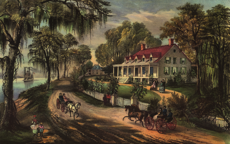
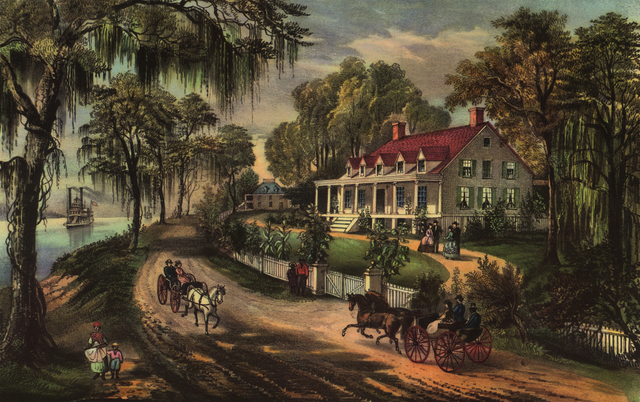
Alfred Waud:
A Home on the Mississippi
|
||||||||||||||||||||||||
|---|---|---|---|---|---|---|---|---|---|---|---|---|---|---|---|---|---|---|---|---|---|---|---|---|
| Artist |
|
 | ||||||||||||||||||||||
| Title |
A Home on the Mississippi |
|||||||||||||||||||||||
| Object type |
lithograph
|
|||||||||||||||||||||||
| Description |
English:
Chromolithograph of the
Woodland Plantation in
West Pointe à la Hache, Louisiana,
United States, by
Currier and Ives. |
|||||||||||||||||||||||
| Date | 1871 | |||||||||||||||||||||||
| Collection |
|
|||||||||||||||||||||||
| Accession number |
LC-USZ62-12927 (b&w film copy neg.) (
Library of Congress)
|
|||||||||||||||||||||||
| Place of creation |
United States of America
|
|||||||||||||||||||||||
| References |
http://www.loc.gov/pictures/item/2002695885/
|
|||||||||||||||||||||||
| Source/Photographer | Digital scan of reprint of original chromolithograph. | |||||||||||||||||||||||
| Permission ( Reusing this file) |
|
|||||||||||||||||||||||

| Object location |
| View this and other nearby images on: OpenStreetMap |
|
|---|
File history
Click on a date/time to view the file as it appeared at that time.
| Date/Time | Thumbnail | Dimensions | User | Comment | |
|---|---|---|---|---|---|
| current | 03:06, 11 August 2009 |
| 2,014 × 1,264 (5.18 MB) | Sapphosyne | {{Information |Description={{en|1= Chromolithograph of the Woodland Plantation in West Pointe à la Hache, Louisiana, [[:en: |
File usage
The following pages on the English Wikipedia use this file (pages on other projects are not listed):
- A Home on the Mississippi
- Confederate States of America
- List of plantations in Louisiana
- Mississippi River
- National Register of Historic Places listings in Plaquemines Parish, Louisiana
- P. G. T. Beauregard
- Southern United States
- Woodland Plantation (West Pointe a la Hache, Louisiana)
- User:GiFontenelle/Sandbox/Q131454, library
- User:Hafspajen/ Pics
Global file usage
The following other wikis use this file:
- Usage on bn.wikipedia.org
- Usage on de.wikipedia.org
- Usage on he.wikipedia.org
- Usage on id.wikipedia.org
- Usage on pt.wikipedia.org
- Usage on si.wikipedia.org
- Usage on www.wikidata.org