
Original file (SVG file, nominally 2,199 × 1,478 pixels, file size: 3.7 MB)
| This is a file from the
Wikimedia Commons. Information from its
description page there is shown below. Commons is a freely licensed media file repository. You can help. |
|
| Rules for editing the map
|
|
| All edit warring, adding of unsourced information or performing a color change without consensus may result in the user being blocked. All contributions should first be discussed on the talk page. |
Summary

|
This file may be updated to reflect new information. If you wish to use a specific version of the file without new updates being mirrored, please upload the required version as a separate file. |
| Description | |||
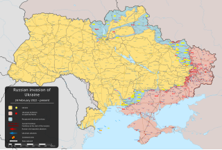
| Date | 24 February 2022 (first version) | ||
| Source |
Own work based on: Russo-Ukrainian conflict (2014-2022).svg by Rr016 & Ukraine adm location map improved.svg by Yakiv Gluck
|
||
| Author | Viewsridge | ||
| Other versions |
|
||
| SVG development | This
map is
translated using SVG switch elements: all translations are stored in the same file.
|


.gif)

.gif)


_en.png)
_vi.png)
_ru.png)
.svg)
This file is translated using SVG <switch> elements. All translations are stored in the same file!
Learn more.
For most Wikipedia projects, you can embed the file normally (without a To translate the text into your language, you can use the SVG Translate tool. Alternatively, you can download the file to your computer, add your translations using whatever software you're familiar with, and re-upload it with the same name. You will find help in Graphics Lab if you're not sure how to do this. |
Licensing
- You are free:
- to share – to copy, distribute and transmit the work
- to remix – to adapt the work
- Under the following conditions:
- attribution – You must give appropriate credit, provide a link to the license, and indicate if changes were made. You may do so in any reasonable manner, but not in any way that suggests the licensor endorses you or your use.
- share alike – If you remix, transform, or build upon the material, you must distribute your contributions under the same or compatible license as the original.
File history
Click on a date/time to view the file as it appeared at that time.
| Date/Time | Thumbnail | Dimensions | User | Comment | |
|---|---|---|---|---|---|
| current | 09:11, 21 April 2024 |
| 2,199 × 1,478 (3.7 MB) | Physeters | Updates per the ISW; mark Krasnohorivka & Bilohorivka as contested per the ISW |
| 07:00, 17 April 2024 |
 | 2,199 × 1,478 (3.7 MB) | Physeters | Small updates per the ISW | |
| 07:38, 8 April 2024 |
 | 2,199 × 1,478 (3.7 MB) | Physeters | Small updates per the ISW; add Synkivka, Kyslivka, Novoiehorivka, Terny, Heorhiivka, and Novomykhailivka | |
| 05:33, 3 April 2024 |
 | 2,199 × 1,478 (3.7 MB) | Physeters | Updates east of Avdiivka per the ISW | |
| 03:04, 27 March 2024 |
 | 2,199 × 1,478 (3.7 MB) | Physeters | Small updates per the ISW | |
| 22:44, 15 March 2024 |
 | 2,199 × 1,478 (3.7 MB) | Physeters | Small updates across the front per the ISW | |
| 02:31, 9 March 2024 |
 | 2,199 × 1,478 (3.7 MB) | Physeters | Updates across the front per the ISW; correct previous zone of occupation in Chernihiv & Sumy Oblasts | |
| 06:58, 29 February 2024 |
 | 2,199 × 1,478 (3.7 MB) | Physeters | Updates in the east per the ISW | |
| 06:32, 25 February 2024 |
 | 2,199 × 1,478 (3.7 MB) | Physeters | Updates across the front per the ISW | |
| 06:20, 20 February 2024 |
 | 2,199 × 1,478 (3.69 MB) | Physeters | Updates across the front per the ISW; Robotyne is contested per the ISW |
File usage
- 2022 Kherson counteroffensive
- Battle of Davydiv Brid
- Battle of Toshkivka
- Crimea attacks (2022–present)
- First battle of Lyman
- List of active separatist movements in Europe
- List of military engagements during the Russian invasion of Ukraine
- Outline of the Russo-Ukrainian War
- Pryazovia
- Russian-occupied territories of Ukraine
- Russian invasion of Ukraine
- Russian occupation of Mykolaiv Oblast
- Russian temporary administrative agencies in occupied Ukraine
- Russo-Ukrainian War and Arctic geopolitics
- Southern Ukraine campaign
- Ukraine
- Talk:List of ongoing armed conflicts
- Talk:Russian invasion of Ukraine/Archive 8
- Talk:Russian invasion of Ukraine/Archive 9
- Talk:Russian occupation of Kharkiv Oblast
- Talk:Ukraine
- User:Blurengo/sandbox
- User:CroatianMonke/sandbox
- User:Edisonabcd/sandbox
- User:Falcaorib
- User:HistoryFanOfItAll1999
- User:Khronicle I/sandbox
- User:LandyYecla/sandbox
- User:LightandDark2000
- User:MLBFanAdrien/sandbox
- User:Msrainynight/sandbox
- User:N8wilson/Infobox military conflict
- User:Plastic1777
- User:Plastic1777/sandbox/User:Plastic1777
- User:RobLa/Ukraine
- User:Sm8900/Russian Invasion of Ukraine (April 2022 to present)
- User:TheVoltigeur/fakecountry/russianpuppetukraine
- User:Vibribyte/sandbox
- User:Xidlaa/sandbox
- Wikipedia:Featured picture candidates/2022 Russian invasion of Ukraine.svg
- Wikipedia:Featured picture candidates/September-2023
- Wikipedia:Graphics Lab/Map workshop/Archive/Sep 2022
- Wikipedia:Top 25 Report/April 10 to 16, 2022
- Wikipedia:Top 25 Report/April 17 to 23, 2022
- Wikipedia:Top 25 Report/April 24 to 30, 2022
- Wikipedia:Top 25 Report/August 28 to September 3, 2022
- Wikipedia:Top 25 Report/February 20 to 26, 2022
- Wikipedia:Top 25 Report/February 27 to March 5, 2022
- Wikipedia:Top 25 Report/July 10 to 16, 2022
- Wikipedia:Top 25 Report/July 17 to 23, 2022
- Wikipedia:Top 25 Report/July 24 to 30, 2022
- Wikipedia:Top 25 Report/July 3 to 9, 2022
- Wikipedia:Top 25 Report/June 19 to 25, 2022
- Wikipedia:Top 25 Report/June 26 to July 2, 2022
- Wikipedia:Top 25 Report/March 13 to 19, 2022
- Wikipedia:Top 25 Report/March 20 to 26, 2022
- Wikipedia:Top 25 Report/March 27 to April 2, 2022
- Wikipedia:Top 25 Report/May 15 to 21, 2022
- Wikipedia:Top 25 Report/May 1 to 7, 2022
- Wikipedia:Top 25 Report/May 29 to June 4, 2022
- Wikipedia:Top 25 Report/May 8 to 14, 2022
- Wikipedia:Top 25 Report/October 16 to 22, 2022
- Wikipedia:Top 25 Report/October 2 to 8, 2022
- Wikipedia:Top 25 Report/October 9 to 15, 2022
- Wikipedia:Top 25 Report/Records
- Wikipedia:Top 25 Report/September 18 to 24, 2022
- Wikipedia:Top 25 Report/September 25 to October 1, 2022
- Wikipedia:Wikipedia Signpost/2022-02-27/News and notes
- Wikipedia:Wikipedia Signpost/2022-03-27/Traffic report
- Wikipedia:Wikipedia Signpost/2022-04-24/Interview
- Wikipedia:Wikipedia Signpost/2022-04-24/Traffic report
- Wikipedia:Wikipedia Signpost/2022-05-29/Traffic report
- Template:Russian invasion of Ukraine infobox
- Template:Russian invasion of Ukraine infobox/sandbox
- Template:Russian invasion of Ukraine infobox/testcases
Global file usage
The following other wikis use this file:
- Usage on af.wikipedia.org
- Usage on als.wikipedia.org
- Usage on am.wikipedia.org
- Usage on ang.wikipedia.org
- Usage on an.wikipedia.org
- Usage on ar.wikipedia.org
- Usage on ary.wikipedia.org
- Usage on arz.wikipedia.org
- Usage on ast.wikipedia.org
- Usage on azb.wikipedia.org
- Usage on az.wikipedia.org
- Usage on bat-smg.wikipedia.org
- Usage on bcl.wikipedia.org
- Usage on be-tarask.wikipedia.org
- Usage on be.wikipedia.org
- Usage on bg.wikipedia.org
- Usage on bh.wikipedia.org
- Usage on bn.wikipedia.org
- Usage on br.wikipedia.org
- Usage on bs.wikipedia.org
- Usage on bxr.wikipedia.org
- Usage on ca.wikipedia.org
View more global usage of this file.