
Size of this PNG preview of this SVG file:
514 × 600 pixels. Other resolutions:
206 × 240 pixels |
411 × 480 pixels |
658 × 768 pixels |
878 × 1,024 pixels |
1,755 × 2,048 pixels |
576 × 672 pixels.
Original file (SVG file, nominally 576 × 672 pixels, file size: 1.17 MB)
| This is a file from the
Wikimedia Commons. Information from its
description page there is shown below. Commons is a freely licensed media file repository. You can help. |
Summary
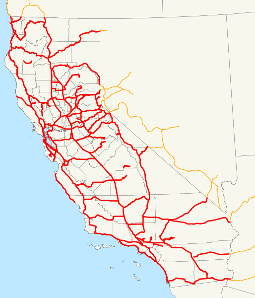
| Description | This is a map of California's state highway system (constructed and proposed routes) as it existed in 1930. Email me if you would like a copy of the GIS data I created for the highways. |
| Date | 23 November 2007 (original upload date) |
| Source | No machine-readable source provided. Own work assumed (based on copyright claims). |
| Author | No machine-readable author provided. NE2 assumed (based on copyright claims). |
Licensing
| I, the copyright holder of this work, release this work into the
public domain. This applies worldwide. In some countries this may not be legally possible; if so: I grant anyone the right to use this work for any purpose, without any conditions, unless such conditions are required by law. |
File history
Click on a date/time to view the file as it appeared at that time.
| Date/Time | Thumbnail | Dimensions | User | Comment | |
|---|---|---|---|---|---|
| current | 18:16, 3 December 2007 |
| 576 × 672 (1.17 MB) | NE2 | Added more in Nevada. |
| 18:14, 3 December 2007 |
 | 576 × 672 (1.17 MB) | NE2 | Added more in Nevada. | |
| 20:41, 2 December 2007 |
 | 576 × 672 (1.17 MB) | NE2 | Made a few corrections, most notably with Route 57. | |
| 16:27, 23 November 2007 |
 | 576 × 672 (1.16 MB) | NE2 | Oops; I put the connecting routes in front. | |
| 16:24, 23 November 2007 |
 | 576 × 672 (1.16 MB) | NE2 | Added connecting routes in adjacent states. | |
| 13:13, 23 November 2007 |
 | 576 × 672 (1.13 MB) | NE2 | This is a map of California's state highway system (constructed and proposed routes) as it existed in 1930. Email me if you would like a copy of the GIS data I created for the highways. Category:State highways in California [[Category:Road maps of th |
File usage
The following pages on the English Wikipedia use this file (pages on other projects are not listed):