No higher resolution available.
1923_Kanto_earthquake_intensity-2.png (512 × 512 pixels, file size: 49 KB, MIME type: image/png)
| This is a file from the
Wikimedia Commons. Information from its
description page there is shown below. Commons is a freely licensed media file repository. You can help. |

|
This incident map image could be re-created using
vector graphics as an
SVG file. This has several advantages; see
Commons:Media for cleanup for more information. If an SVG form of this image is available, please upload it and afterwards replace this template with
{{
vector version available|new image name}}
.
It is recommended to name the SVG file “1923 Kanto earthquake intensity-2.svg”—then the template Vector version available (or Vva) does not need the new image name parameter. |
Summary
| Description |
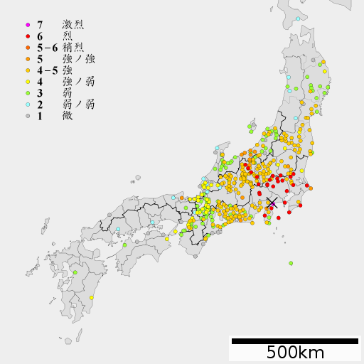
English: 1923 Kanto earthquake intensity
日本語: 1923年関東地震の震度分布 |
| Date | |
| Source | Lincun(2010)ファイル:地図 令制国 和泉国.svg, 中央気象台月別全国地震調査原稿 大正12年9月 |
| Author | As6022014 |
Licensing
I, the copyright holder of this work, hereby publish it under the following license:
This file is licensed under the
Creative Commons
Attribution-Share Alike 3.0 Unported license.
- You are free:
- to share – to copy, distribute and transmit the work
- to remix – to adapt the work
- Under the following conditions:
- attribution – You must give appropriate credit, provide a link to the license, and indicate if changes were made. You may do so in any reasonable manner, but not in any way that suggests the licensor endorses you or your use.
- share alike – If you remix, transform, or build upon the material, you must distribute your contributions under the same or compatible license as the original.
File history
Click on a date/time to view the file as it appeared at that time.
| Date/Time | Thumbnail | Dimensions | User | Comment | |
|---|---|---|---|---|---|
| current | 08:32, 8 March 2012 |
| 512 × 512 (49 KB) | As6022014 | {{Information |Description ={{en|1=1923 Kanto earthquake intensity}} {{ja|1=1923年関東地震の震度分布}} |Source =Lincun(2010)ファイル:地図 令制国 和泉国.svg, 中央気象台月別全国地震調査原稿 大正12年9月 ... |
File usage
The following pages on the English Wikipedia use this file (pages on other projects are not listed):
Global file usage
The following other wikis use this file:
- Usage on be.wikipedia.org
- Usage on id.wikipedia.org
- Usage on ja.wikipedia.org
- Usage on ko.wikipedia.org
- Usage on sl.wikipedia.org
- Usage on th.wikipedia.org
- Usage on vi.wikipedia.org
- Usage on www.wikidata.org